You are here: Home > Network List > US - United States National Seismic Network Stations List
> Station KNB Kanab, Kane County, Utah, USA > Earthquake Result Viewer
KNB Kanab, Kane County, Utah, USA - Earthquake Result Viewer
| Earthquake location: |
Kermadec Islands, New Zealand |
| Earthquake latitude/longitude: |
-30.5/-179.0 |
| Earthquake time(UTC): |
1998/07/09 (190) 14:45:39 GMT |
| Earthquake Depth: |
130 km |
| Earthquake Magnitude: |
6.2 MB, 6.2 MS, 6.9 UNKNOWN, 6.4 ME |
| Earthquake Catalog/Contributor: |
WHDF/NEIC |
|
| Network: |
US United States National Seismic Network |
| Station: |
KNB Kanab, Kane County, Utah, USA |
| Lat/Lon: |
37.02 N/112.82 W |
| Elevation: |
1715 m |
|
| Distance: |
91.3 deg |
| Az: |
47.086 deg |
| Baz: |
232.173 deg |
| Ray Param: |
0.041567277 |
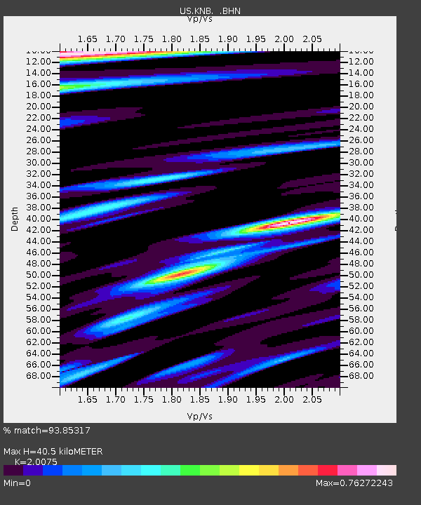
| Estimated Moho Depth: |
40.5 km |
| Estimated Crust Vp/Vs: |
2.01 |
| Assumed Crust Vp: |
6.194 km/s |
| Estimated Crust Vs: |
3.086 km/s |
| Estimated Crust Poisson's Ratio: |
0.33 |
|
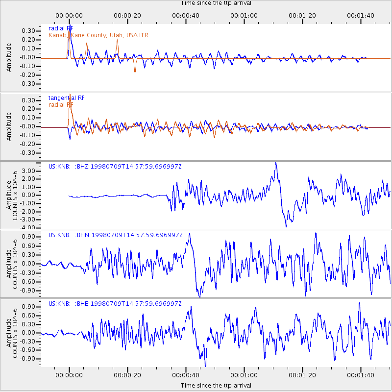
| Radial Match: |
93.85317 % |
| Radial Bump: |
400 |
| Transverse Match: |
79.18334 % |
| Transverse Bump: |
400 |
| SOD ConfigId: |
110177 |
| Insert Time: |
2010-03-05 06:56:48.191 +0000 |
| GWidth: |
2.5 |
| Max Bumps: |
400 |
| Tol: |
0.001 |
|
Signal To Noise
| Channel | StoN | STA | LTA |
| US:KNB: :BHN:19980709T14:57:59.696997Z | 1.2102245 | 7.648377E-8 | 6.3198E-8 |
| US:KNB: :BHE:19980709T14:57:59.696997Z | 0.7982666 | 3.4211038E-8 | 4.2856655E-8 |
| US:KNB: :BHZ:19980709T14:57:59.696997Z | 3.1198263 | 2.5077455E-7 | 8.038093E-8 |
| Arrivals |
| Ps | 6.7 SECOND |
| PpPs | 19 SECOND |
| PsPs/PpSs | 26 SECOND |


