You are here: Home > Network List > US - United States National Seismic Network Stations List
> Station KNB Kanab, Kane County, Utah, USA > Earthquake Result Viewer
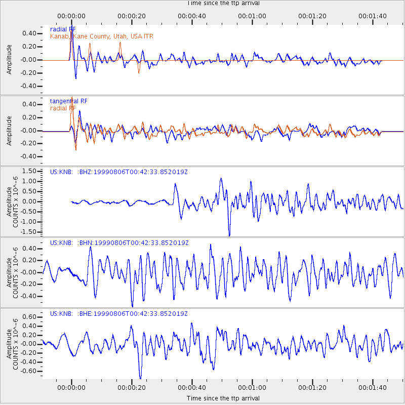
KNB Kanab, Kane County, Utah, USA - Earthquake Result Viewer
| Earthquake location: |
Kuril Islands |
| Earthquake latitude/longitude: |
49.9/156.3 |
| Earthquake time(UTC): |
1999/08/06 (218) 00:32:41 GMT |
| Earthquake Depth: |
58 km |
| Earthquake Magnitude: |
5.5 MB, 5.5 MS, 5.9 MW, 5.8 MW |
| Earthquake Catalog/Contributor: |
WHDF/NEIC |
|
| Network: |
US United States National Seismic Network |
| Station: |
KNB Kanab, Kane County, Utah, USA |
| Lat/Lon: |
37.02 N/112.82 W |
| Elevation: |
1715 m |
|
| Distance: |
63.3 deg |
| Az: |
63.607 deg |
| Baz: |
313.68 deg |
| Ray Param: |
0.05952985 |
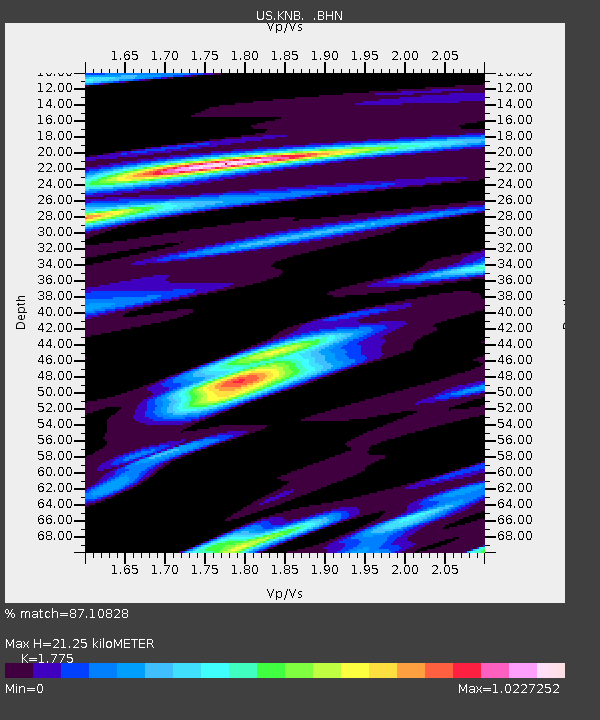
| Estimated Moho Depth: |
21.25 km |
| Estimated Crust Vp/Vs: |
1.77 |
| Assumed Crust Vp: |
6.194 km/s |
| Estimated Crust Vs: |
3.49 km/s |
| Estimated Crust Poisson's Ratio: |
0.27 |
|
| Radial Match: |
87.10828 % |
| Radial Bump: |
400 |
| Transverse Match: |
69.19216 % |
| Transverse Bump: |
400 |
| SOD ConfigId: |
110177 |
| Insert Time: |
2010-03-05 06:56:49.619 +0000 |
| GWidth: |
2.5 |
| Max Bumps: |
400 |
| Tol: |
0.001 |
|
Signal To Noise
| Channel | StoN | STA | LTA |
| US:KNB: :BHN:19990806T00:42:33.852019Z | 1.1165954 | 8.8520366E-8 | 7.927704E-8 |
| US:KNB: :BHE:19990806T00:42:33.852019Z | 1.8671432 | 1.5771015E-7 | 8.4466016E-8 |
| US:KNB: :BHZ:19990806T00:42:33.852019Z | 4.636591 | 3.0047076E-7 | 6.480425E-8 |
| Arrivals |
| Ps | 2.8 SECOND |
| PpPs | 9.1 SECOND |
| PsPs/PpSs | 12 SECOND |


