You are here: Home > Network List > US - United States National Seismic Network Stations List
> Station KNB Kanab, Kane County, Utah, USA > Earthquake Result Viewer
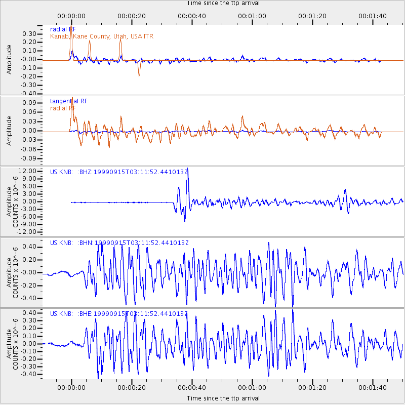
KNB Kanab, Kane County, Utah, USA - Earthquake Result Viewer
| Earthquake location: |
Southern Bolivia |
| Earthquake latitude/longitude: |
-20.9/-67.3 |
| Earthquake time(UTC): |
1999/09/15 (258) 03:01:24 GMT |
| Earthquake Depth: |
218 km |
| Earthquake Magnitude: |
6.0 MB, 6.4 MW, 6.4 MW |
| Earthquake Catalog/Contributor: |
WHDF/NEIC |
|
| Network: |
US United States National Seismic Network |
| Station: |
KNB Kanab, Kane County, Utah, USA |
| Lat/Lon: |
37.02 N/112.82 W |
| Elevation: |
1715 m |
|
| Distance: |
71.9 deg |
| Az: |
323.046 deg |
| Baz: |
135.403 deg |
| Ray Param: |
0.053431317 |
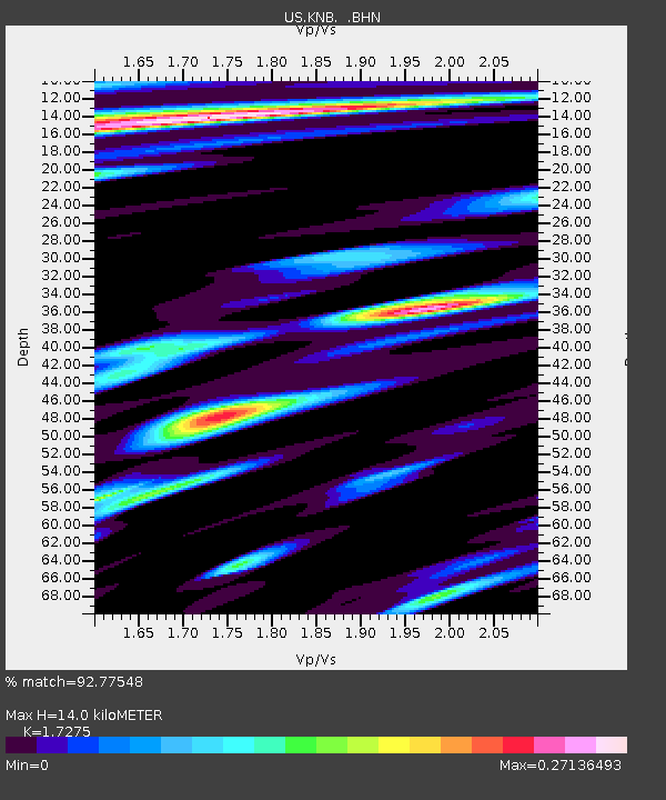
| Estimated Moho Depth: |
14.0 km |
| Estimated Crust Vp/Vs: |
1.73 |
| Assumed Crust Vp: |
6.194 km/s |
| Estimated Crust Vs: |
3.586 km/s |
| Estimated Crust Poisson's Ratio: |
0.25 |
|
| Radial Match: |
92.77548 % |
| Radial Bump: |
400 |
| Transverse Match: |
88.22673 % |
| Transverse Bump: |
400 |
| SOD ConfigId: |
110177 |
| Insert Time: |
2010-03-05 06:56:51.523 +0000 |
| GWidth: |
2.5 |
| Max Bumps: |
400 |
| Tol: |
0.001 |
|
Signal To Noise
| Channel | StoN | STA | LTA |
| US:KNB: :BHN:19990915T03:11:52.441013Z | 1.976435 | 5.4181598E-8 | 2.7413805E-8 |
| US:KNB: :BHE:19990915T03:11:52.441013Z | 2.1838562 | 4.973374E-8 | 2.2773358E-8 |
| US:KNB: :BHZ:19990915T03:11:52.441013Z | 25.301434 | 1.1437846E-6 | 4.5206317E-8 |
| Arrivals |
| Ps | 1.7 SECOND |
| PpPs | 6.0 SECOND |
| PsPs/PpSs | 7.7 SECOND |


