You are here: Home > Network List > US - United States National Seismic Network Stations List
> Station KNB Kanab, Kane County, Utah, USA > Earthquake Result Viewer
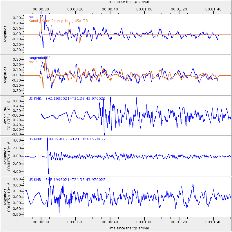
KNB Kanab, Kane County, Utah, USA - Earthquake Result Viewer
*The percent match for this event was below the threshold and hence no stack was calculated.
| Earthquake location: |
Southeast Of Honshu, Japan |
| Earthquake latitude/longitude: |
29.2/140.4 |
| Earthquake time(UTC): |
1996/02/14 (045) 21:26:56 GMT |
| Earthquake Depth: |
142 km |
| Earthquake Magnitude: |
5.9 MB |
| Earthquake Catalog/Contributor: |
WHDF/NEIC |
|
| Network: |
US United States National Seismic Network |
| Station: |
KNB Kanab, Kane County, Utah, USA |
| Lat/Lon: |
37.02 N/112.82 W |
| Elevation: |
1715 m |
|
| Distance: |
84.9 deg |
| Az: |
50.292 deg |
| Baz: |
302.84 deg |
| Ray Param: |
$rayparam |
*The percent match for this event was below the threshold and hence was not used in the summary stack. |
|
| Radial Match: |
73.62312 % |
| Radial Bump: |
400 |
| Transverse Match: |
63.620853 % |
| Transverse Bump: |
400 |
| SOD ConfigId: |
4480 |
| Insert Time: |
2010-03-05 06:56:57.124 +0000 |
| GWidth: |
2.5 |
| Max Bumps: |
400 |
| Tol: |
0.001 |
|
Signal To Noise
| Channel | StoN | STA | LTA |
| US:KNB: :BHN:19960214T21:38:43.97002Z | 11.80584 | 1.3983495E-6 | 1.1844558E-7 |
| US:KNB: :BHE:19960214T21:38:43.97002Z | 1.500682 | 2.5630402E-7 | 1.7079171E-7 |
| US:KNB: :BHZ:19960214T21:38:43.97002Z | 1.5861486 | 1.6645608E-7 | 1.0494356E-7 |
| Arrivals |
| Ps | |
| PpPs | |
| PsPs/PpSs | |


