You are here: Home > Network List > US - United States National Seismic Network Stations List
> Station KNB Kanab, Kane County, Utah, USA > Earthquake Result Viewer
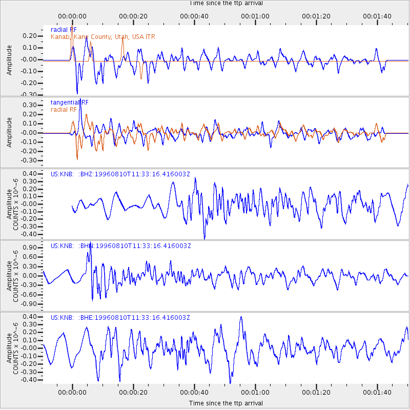
KNB Kanab, Kane County, Utah, USA - Earthquake Result Viewer
*The percent match for this event was below the threshold and hence no stack was calculated.
| Earthquake location: |
New Britain Region, P.N.G. |
| Earthquake latitude/longitude: |
-4.9/152.1 |
| Earthquake time(UTC): |
1996/08/10 (223) 11:20:19 GMT |
| Earthquake Depth: |
33 km |
| Earthquake Magnitude: |
5.6 MB, 6.0 MS, 6.2 UNKNOWN, 6.1 MW |
| Earthquake Catalog/Contributor: |
WHDF/NEIC |
|
| Network: |
US United States National Seismic Network |
| Station: |
KNB Kanab, Kane County, Utah, USA |
| Lat/Lon: |
37.02 N/112.82 W |
| Elevation: |
1715 m |
|
| Distance: |
97.0 deg |
| Az: |
53.44 deg |
| Baz: |
269.082 deg |
| Ray Param: |
$rayparam |
*The percent match for this event was below the threshold and hence was not used in the summary stack. |
|
| Radial Match: |
82.83687 % |
| Radial Bump: |
400 |
| Transverse Match: |
69.077156 % |
| Transverse Bump: |
339 |
| SOD ConfigId: |
4480 |
| Insert Time: |
2010-03-05 06:57:00.198 +0000 |
| GWidth: |
2.5 |
| Max Bumps: |
400 |
| Tol: |
0.001 |
|
Signal To Noise
| Channel | StoN | STA | LTA |
| US:KNB: :BHN:19960810T11:33:16.416003Z | 1.2418008 | 1.7638162E-7 | 1.4203697E-7 |
| US:KNB: :BHE:19960810T11:33:16.416003Z | 1.1806831 | 1.6238958E-7 | 1.3753866E-7 |
| US:KNB: :BHZ:19960810T11:33:16.416003Z | 2.3278384 | 1.6677016E-7 | 7.1641644E-8 |
| Arrivals |
| Ps | |
| PpPs | |
| PsPs/PpSs | |


