You are here: Home > Network List > US - United States National Seismic Network Stations List
> Station KNB Kanab, Kane County, Utah, USA > Earthquake Result Viewer
KNB Kanab, Kane County, Utah, USA - Earthquake Result Viewer
*The percent match for this event was below the threshold and hence no stack was calculated.
| Earthquake location: |
Kuril Islands |
| Earthquake latitude/longitude: |
45.4/151.6 |
| Earthquake time(UTC): |
1999/05/08 (128) 19:44:35 GMT |
| Earthquake Depth: |
63 km |
| Earthquake Magnitude: |
6.2 MB, 5.3 MS, 5.9 MW, 5.9 MW |
| Earthquake Catalog/Contributor: |
WHDF/NEIC |
|
| Network: |
US United States National Seismic Network |
| Station: |
KNB Kanab, Kane County, Utah, USA |
| Lat/Lon: |
37.02 N/112.82 W |
| Elevation: |
1715 m |
|
| Distance: |
68.2 deg |
| Az: |
59.092 deg |
| Baz: |
311.011 deg |
| Ray Param: |
$rayparam |
*The percent match for this event was below the threshold and hence was not used in the summary stack. |
|
| Radial Match: |
75.303406 % |
| Radial Bump: |
400 |
| Transverse Match: |
79.94393 % |
| Transverse Bump: |
400 |
| SOD ConfigId: |
4480 |
| Insert Time: |
2010-03-05 06:57:01.694 +0000 |
| GWidth: |
2.5 |
| Max Bumps: |
400 |
| Tol: |
0.001 |
|
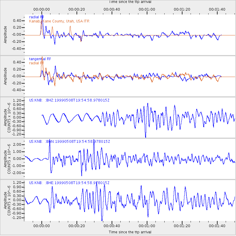
Signal To Noise
| Channel | StoN | STA | LTA |
| US:KNB: :BHN:19990508T19:54:58.978015Z | 3.1052094 | 7.5296003E-7 | 2.4248286E-7 |
| US:KNB: :BHE:19990508T19:54:58.978015Z | 1.4494066 | 2.579216E-7 | 1.779498E-7 |
| US:KNB: :BHZ:19990508T19:54:58.978015Z | 0.78035194 | 1.6470102E-7 | 2.1105994E-7 |
| Arrivals |
| Ps | |
| PpPs | |
| PsPs/PpSs | |


