You are here: Home > Network List > US - United States National Seismic Network Stations List
> Station CBM Caribou, Maine, USA > Earthquake Result Viewer
CBM Caribou, Maine, USA - Earthquake Result Viewer
| Earthquake location: |
Hokkaido, Japan Region |
| Earthquake latitude/longitude: |
43.4/143.3 |
| Earthquake time(UTC): |
1993/01/15 (015) 11:06:05 GMT |
| Earthquake Depth: |
100 km |
| Earthquake Magnitude: |
6.9 MB, 7.1 MS |
| Earthquake Catalog/Contributor: |
WHDF/NEIC |
|
| Network: |
US United States National Seismic Network |
| Station: |
CBM Caribou, Maine, USA |
| Lat/Lon: |
46.93 N/68.12 W |
| Elevation: |
250 m |
|
| Distance: |
85.9 deg |
| Az: |
20.964 deg |
| Baz: |
337.635 deg |
| Ray Param: |
0.04425499 |
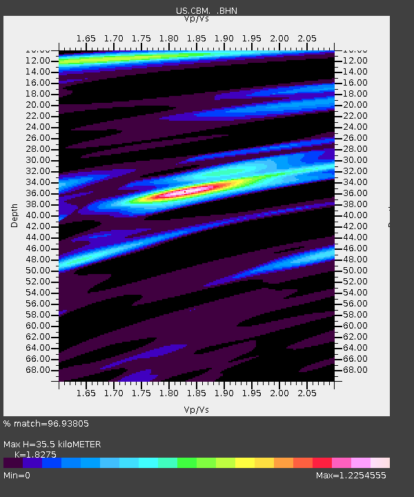
| Estimated Moho Depth: |
35.5 km |
| Estimated Crust Vp/Vs: |
1.83 |
| Assumed Crust Vp: |
6.419 km/s |
| Estimated Crust Vs: |
3.513 km/s |
| Estimated Crust Poisson's Ratio: |
0.29 |
|
| Radial Match: |
96.93805 % |
| Radial Bump: |
400 |
| Transverse Match: |
84.1142 % |
| Transverse Bump: |
400 |
| SOD ConfigId: |
110177 |
| Insert Time: |
2010-03-05 06:58:49.226 +0000 |
| GWidth: |
2.5 |
| Max Bumps: |
400 |
| Tol: |
0.001 |
|

Signal To Noise
| Channel | StoN | STA | LTA |
| US:CBM: :BHN:19930115T11:18:02.40802Z | 2.9358885 | 1.3490459E-6 | 4.5950173E-7 |
| US:CBM: :BHE:19930115T11:18:02.40802Z | 1.6669669 | 5.775268E-7 | 3.4645367E-7 |
| US:CBM: :BHZ:19930115T11:18:02.40802Z | 5.295565 | 3.9946344E-6 | 7.543358E-7 |
| Arrivals |
| Ps | 4.7 SECOND |
| PpPs | 15 SECOND |
| PsPs/PpSs | 20 SECOND |


