
Station US CBM - Caribou, Maine, USA
Network: US - United States National Seismic Network
Nearby stations (2 deg radius)

| Station | Name | (Lat, Lon) | Start / End | Elevation |
| CBM | Caribou, Maine, USA | (46.93, -68.12) | 1992-11-02 / 2499-01-01 | 250 m |
| Crust2 Type: | Q2,orogen/39km no ice, Appalachians, North Andes, 0.5 km seds. |
| Thickness Estimate: | 38 km |
| Thickness StdDev: | 2.2 km |
| Vp/Vs Estimate: | 1.82 |
| Vp/Vs StdDev: | 0.10 |
| Vs Estimate: | 3.527 km/s |
| Poisson's Ratio: | 0.28 |
| Peak Value: | 0.04 |
| Assumed Vp: | 6.419 km/s |
| Ps Weight: | 0.33333334 |
| PpPs Weight: | 0.33333334 |
| PsPs Weight: | 0.33333328 |
| Residual Complexity: | 0.700 |
| Nearby stations H: | +- |
| (2.0 deg) Vp/Vs: | +- |
2 with match > 90% ( 28.571428 %) and 4 with match > 80% ( 57.142857 %) out of 7.
Download stack as xyz text file.
Azimuth Distribution of Events:

Prior Results for this Station
| Study | Thickness | Vp/Vs | Vp | Vs | Poissons Ratio | Extra |
| EARS | 38 km | 1.82 | 6.419 km/s | 3.527 km/s | 0.28 | |
| Crust2.0 | 39 km | 1.75 | 6.419 km/s | 3.659 km/s | 0.26 | Q2,orogen/39km no ice, Appalachians, North Andes, 0.5 km seds. |
| Zandt Ammon | 32 km | 1.76 | 6.0 km/s | 3.409 km/s | 0.26 | |
| Zandt Ammon | 33 km | 1.76 | 6.25 km/s | 3.551 km/s | 0.26 | |
| Zandt Ammon | 35 km | 1.75 | 6.5 km/s | 3.714 km/s | 0.26 | |
| Zandt Ammon | 36 km | 1.74 | 6.75 km/s | 3.879 km/s | 0.25 | |
| Global Maxima | 38 km | 1.82 | 6.419 km/s | 3.527 km/s | 0.28 | amp=0.042054936 |
| Local Maxima 1 | 33 km | 1.97 | 6.419 km/s | 3.254 km/s | 0.33 | amp=0.038296074 |
| Local Maxima 2 | 30 km | 1.94 | 6.419 km/s | 3.313 km/s | 0.32 | amp=0.022630304 |
| Local Maxima 3 | 48 km | 2.04 | 6.419 km/s | 3.154 km/s | 0.34 | amp=0.019305216 |
| Local Maxima 4 | 33 km | 1.79 | 6.419 km/s | 3.586 km/s | 0.27 | amp=0.013276676 |
| Predicted Arrivals for vertical incidence (zero ray parameter) | |
| Ps | 4.79 SECOND |
| PpPs | 16.47 SECOND |
| PsPs/PpSs | 21.26 SECOND |
Events Processed for this Station
Download zip of receiver functions as SAC
Plot maxima for each earthquake.
Events Used in the Stack
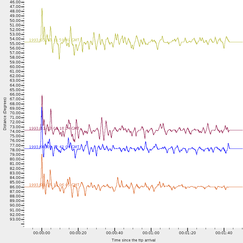
(4 events)| Radial Match | Distance | Baz | FERegion | Time | Lat/Lon | Depth | Magnitude |
| 96.93805 | 85.9 deg | 337.635 deg | Hokkaido, Japan Region | 1993/01/15 11:06:05 GMT | (43.4, 143.3) | 100 km | 6.9 MB, 7.1 MS |
| 91.111305 | 77.6 deg | 61.367 deg | Egypt | 1993/08/03 12:43:04 GMT | (28.6, 34.6) | 10 km | 6.0 MB, 5.7 MS, 6.1 UNKNOWN, 6.0 MW |
| 88.2893 | 54.5 deg | 315.26 deg | Alaska Peninsula | 1993/05/13 11:59:49 GMT | (55.2, -160.5) | 32 km | 6.4 MB, 6.8 MS, 6.8 UNKNOWN |
| 87.98234 | 73.7 deg | 331.922 deg | Near East Coast Of Kamchatka | 1993/11/13 01:18:04 GMT | (51.9, 158.7) | 34 km | 6.5 MB, 7.1 MS, 6.9 UNKNOWN |
Losers
(3 events)| Radial Match | Distance | Baz | FERegion | Time | Lat/Lon | Depth | Magnitude | Reason |
| 79.73001 | 60.9 deg | 315.011 deg | Fox Islands, Aleutian Islands | 1993/04/14 05:58:32 GMT | (51.3, -168.8) | 33 km | 5.6 MB, 5.4 MS | |
| 77.2845 | 38.4 deg | 220.534 deg | Near Coast Of Chiapas, Mexico | 1993/09/10 18:58:52 GMT | (14.4, -92.7) | 25 km | 5.7 MB, 5.9 UNKNOWN, 5.9 MD | |
| 74.91366 | 73.5 deg | 182.769 deg | Off Coast Of Northern Chile | 1993/03/19 01:48:05 GMT | (-26.9, -71.1) | 34 km | 5.5 MB, 5.6 MS |
