You are here: Home > Network List > US - United States National Seismic Network Stations List
> Station CBM Caribou, Maine, USA > Earthquake Result Viewer
CBM Caribou, Maine, USA - Earthquake Result Viewer
| Earthquake location: |
Alaska Peninsula |
| Earthquake latitude/longitude: |
55.2/-160.5 |
| Earthquake time(UTC): |
1993/05/13 (133) 11:59:49 GMT |
| Earthquake Depth: |
32 km |
| Earthquake Magnitude: |
6.4 MB, 6.8 MS, 6.8 UNKNOWN |
| Earthquake Catalog/Contributor: |
WHDF/NEIC |
|
| Network: |
US United States National Seismic Network |
| Station: |
CBM Caribou, Maine, USA |
| Lat/Lon: |
46.93 N/68.12 W |
| Elevation: |
250 m |
|
| Distance: |
54.5 deg |
| Az: |
57.238 deg |
| Baz: |
315.26 deg |
| Ray Param: |
0.06534514 |
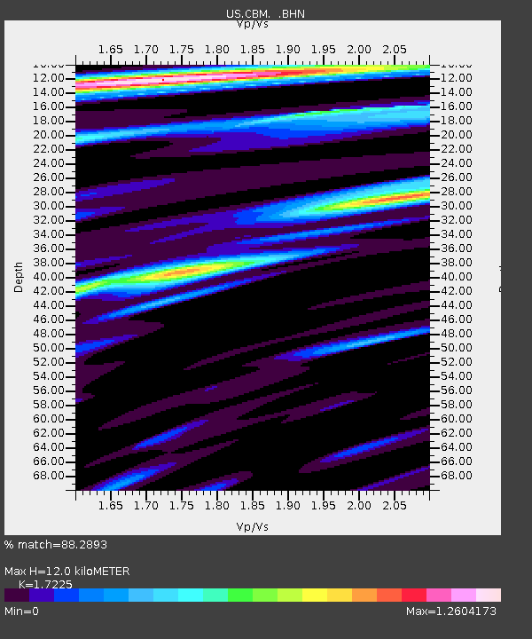
| Estimated Moho Depth: |
12.0 km |
| Estimated Crust Vp/Vs: |
1.72 |
| Assumed Crust Vp: |
6.419 km/s |
| Estimated Crust Vs: |
3.727 km/s |
| Estimated Crust Poisson's Ratio: |
0.25 |
|
| Radial Match: |
88.2893 % |
| Radial Bump: |
400 |
| Transverse Match: |
74.1235 % |
| Transverse Bump: |
400 |
| SOD ConfigId: |
110177 |
| Insert Time: |
2010-03-05 06:58:50.542 +0000 |
| GWidth: |
2.5 |
| Max Bumps: |
400 |
| Tol: |
0.001 |
|

Signal To Noise
| Channel | StoN | STA | LTA |
| US:CBM: :BHN:19930513T12:08:43.226001Z | 2.0569813 | 7.1572936E-7 | 3.479513E-7 |
| US:CBM: :BHE:19930513T12:08:43.226001Z | 2.8061748 | 8.4496963E-7 | 3.0111084E-7 |
| US:CBM: :BHZ:19930513T12:08:43.226001Z | 6.0584226 | 2.4973303E-6 | 4.12208E-7 |
| Arrivals |
| Ps | 1.4 SECOND |
| PpPs | 4.8 SECOND |
| PsPs/PpSs | 6.2 SECOND |


