You are here: Home > Network List > US - United States National Seismic Network Stations List
> Station CBM Caribou, Maine, USA > Earthquake Result Viewer
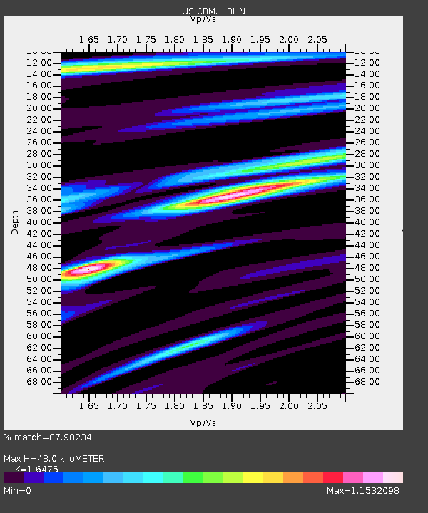
CBM Caribou, Maine, USA - Earthquake Result Viewer
| Earthquake location: |
Near East Coast Of Kamchatka |
| Earthquake latitude/longitude: |
51.9/158.7 |
| Earthquake time(UTC): |
1993/11/13 (317) 01:18:04 GMT |
| Earthquake Depth: |
34 km |
| Earthquake Magnitude: |
6.5 MB, 7.1 MS, 6.9 UNKNOWN |
| Earthquake Catalog/Contributor: |
WHDF/NEIC |
|
| Network: |
US United States National Seismic Network |
| Station: |
CBM Caribou, Maine, USA |
| Lat/Lon: |
46.93 N/68.12 W |
| Elevation: |
250 m |
|
| Distance: |
73.7 deg |
| Az: |
31.386 deg |
| Baz: |
331.922 deg |
| Ray Param: |
0.052806657 |
| Estimated Moho Depth: |
48.0 km |
| Estimated Crust Vp/Vs: |
1.65 |
| Assumed Crust Vp: |
6.419 km/s |
| Estimated Crust Vs: |
3.896 km/s |
| Estimated Crust Poisson's Ratio: |
0.21 |
|
| Radial Match: |
87.98234 % |
| Radial Bump: |
400 |
| Transverse Match: |
71.7716 % |
| Transverse Bump: |
400 |
| SOD ConfigId: |
110177 |
| Insert Time: |
2010-03-05 06:58:52.480 +0000 |
| GWidth: |
2.5 |
| Max Bumps: |
400 |
| Tol: |
0.001 |
|

Signal To Noise
| Channel | StoN | STA | LTA |
| US:CBM: :BHN:19931113T01:29:03.366016Z | 2.2765284 | 1.1794514E-6 | 5.1809207E-7 |
| US:CBM: :BHE:19931113T01:29:03.366016Z | 2.418723 | 1.0145318E-6 | 4.1944932E-7 |
| US:CBM: :BHZ:19931113T01:29:03.366016Z | 5.196501 | 3.2268915E-6 | 6.2097394E-7 |
| Arrivals |
| Ps | 5.0 SECOND |
| PpPs | 19 SECOND |
| PsPs/PpSs | 24 SECOND |


