You are here: Home > Network List > US - United States National Seismic Network Stations List
> Station HKT Hockley, Texas, USA > Earthquake Result Viewer
HKT Hockley, Texas, USA - Earthquake Result Viewer
| Earthquake location: |
Unimak Island Region, Alaska |
| Earthquake latitude/longitude: |
53.6/-164.6 |
| Earthquake time(UTC): |
2003/02/19 (050) 03:32:36 GMT |
| Earthquake Depth: |
19 km |
| Earthquake Magnitude: |
5.8 MB, 6.6 MS, 6.6 MW, 6.6 MW |
| Earthquake Catalog/Contributor: |
WHDF/NEIC |
|
| Network: |
US United States National Seismic Network |
| Station: |
HKT Hockley, Texas, USA |
| Lat/Lon: |
29.95 N/95.83 W |
| Elevation: |
-415.0 m |
|
| Distance: |
54.1 deg |
| Az: |
86.91 deg |
| Baz: |
316.766 deg |
| Ray Param: |
0.06561619 |
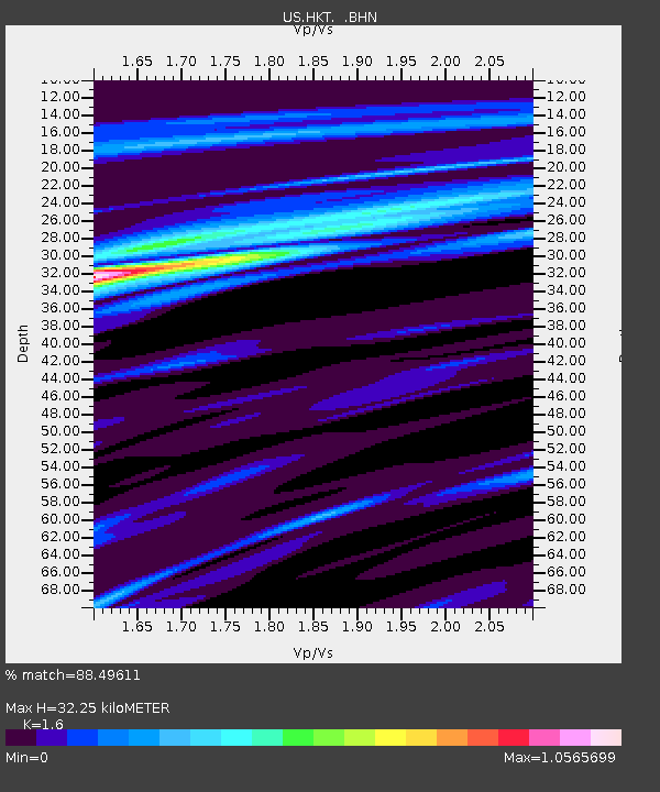
| Estimated Moho Depth: |
32.25 km |
| Estimated Crust Vp/Vs: |
1.60 |
| Assumed Crust Vp: |
5.581 km/s |
| Estimated Crust Vs: |
3.488 km/s |
| Estimated Crust Poisson's Ratio: |
0.18 |
|
| Radial Match: |
88.49611 % |
| Radial Bump: |
373 |
| Transverse Match: |
69.82131 % |
| Transverse Bump: |
379 |
| SOD ConfigId: |
110177 |
| Insert Time: |
2010-03-05 07:06:50.381 +0000 |
| GWidth: |
2.5 |
| Max Bumps: |
400 |
| Tol: |
0.001 |
|

Signal To Noise
| Channel | StoN | STA | LTA |
| US:HKT: :BHN:20030219T03:41:29.159011Z | 0.7494056 | 4.624052E-7 | 6.170293E-7 |
| US:HKT: :BHE:20030219T03:41:29.159011Z | 1.0558151 | 1.8916947E-7 | 1.7916912E-7 |
| US:HKT: :BHZ:20030219T03:41:29.159011Z | 2.9086072 | 1.3312109E-6 | 4.5767982E-7 |
| Arrivals |
| Ps | 3.6 SECOND |
| PpPs | 14 SECOND |
| PsPs/PpSs | 18 SECOND |


