
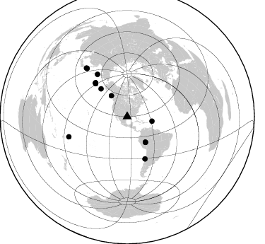
Station US HKT - Hockley, Texas, USA
Network: US - United States National Seismic Network
Nearby stations (2 deg radius)

| Station | Name | (Lat, Lon) | Start / End | Elevation |
| HKT | Hockley, Texas, USA | (29.95, -95.83) | 1995-08-22 / 2499-01-01 | -415.0 m |
| Crust2 Type: | SC,continental slope, margin, transition 11.5 km seds. |
| Thickness Estimate: | 30 km |
| Thickness StdDev: | 2.4 km |
| Vp/Vs Estimate: | 1.62 |
| Vp/Vs StdDev: | 0.09 |
| Vs Estimate: | 3.435 km/s |
| Poisson's Ratio: | 0.20 |
| Peak Value: | 0.04 |
| Assumed Vp: | 5.581 km/s |
| Ps Weight: | 0.33333334 |
| PpPs Weight: | 0.33333334 |
| PsPs Weight: | 0.33333328 |
| Residual Complexity: | 0.809 |
| Nearby stations H: | 31 km +- 1.4 km |
| (2.0 deg) Vp/Vs: | 1.63 +- 0.01 |
8 with match > 90% ( 57.142857 %) and 14 with match > 80% ( 100.0 %) out of 14.
Download stack as xyz text file.
Azimuth Distribution of Events:
Prior Results for this Station
| Study | Thickness | Vp/Vs | Vp | Vs | Poissons Ratio | Extra |
| EARS | 30 km | 1.62 | 5.581 km/s | 3.435 km/s | 0.20 | |
| Crust2.0 | 27 km | 1.82 | 5.581 km/s | 3.07 km/s | 0.28 | SC,continental slope, margin, transition 11.5 km seds. |
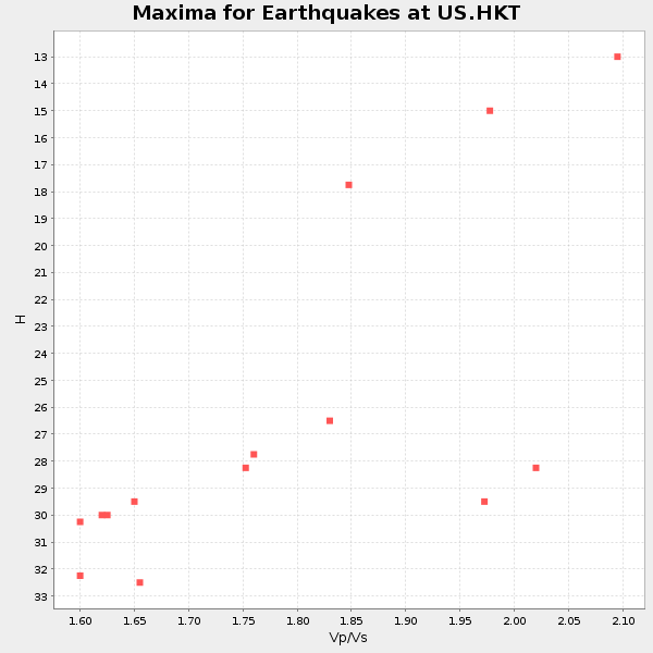
| Global Maxima | 30 km | 1.62 | 5.581 km/s | 3.435 km/s | 0.20 | amp=0.035605907 |
| Local Maxima 1 | 26 km | 1.84 | 5.581 km/s | 3.038 km/s | 0.29 | amp=0.03186173 |
| Local Maxima 2 | 28 km | 2.09 | 5.581 km/s | 2.671 km/s | 0.35 | amp=0.022119952 |
| Local Maxima 3 | 32 km | 1.61 | 5.581 km/s | 3.467 km/s | 0.19 | amp=0.021222439 |
| Local Maxima 4 | 36 km | 1.65 | 5.581 km/s | 3.388 km/s | 0.21 | amp=0.017396975 |
| Predicted Arrivals for vertical incidence (zero ray parameter) | |
| Ps | 3.36 SECOND |
| PpPs | 14.11 SECOND |
| PsPs/PpSs | 17.47 SECOND |
Events Processed for this Station
Download zip of receiver functions as SAC
Plot maxima for each earthquake.
Events Used in the Stack
(14 events)| Radial Match | Distance | Baz | FERegion | Time | Lat/Lon | Depth | Magnitude |
| 97.0957 | 89.8 deg | 319.782 deg | Hokkaido, Japan Region | 2003/09/25 19:50:06 GMT | (41.8, 143.9) | 27 km | 6.9 MB, 8.1 MS, 8.3 MW, 8.1 MW |
| 96.73795 | 73.3 deg | 324.821 deg | Kamchatka Peninsula, Russia | 2003/06/16 22:08:02 GMT | (55.5, 160.0) | 175 km | 6.3 MB, 6.9 MW, 6.9 MW |
| 96.216805 | 64.5 deg | 156.947 deg | Near Coast Of Central Chile | 2003/06/20 13:30:41 GMT | (-30.6, -71.6) | 33 km | 6.4 MB, 6.8 MS, 6.8 MW, 6.7 MW |
| 94.93166 | 64.6 deg | 315.972 deg | Rat Islands, Aleutian Islands | 2003/11/17 06:43:06 GMT | (51.1, 178.6) | 33 km | 6.2 MB, 7.2 MS, 7.8 MW, 7.7 MW |
| 93.37087 | 65.0 deg | 316.241 deg | Rat Islands, Aleutian Islands | 2003/03/17 16:36:17 GMT | (51.3, 178.0) | 33 km | 5.9 MB, 6.7 MS, 7.0 MW, 7.0 MW |
| 92.96057 | 43.9 deg | 144.3 deg | Western Brazil | 2003/06/20 06:19:38 GMT | (-7.6, -71.7) | 558 km | 6.4 MB, 7.1 MW, 7.0 MW |
| 92.661575 | 35.7 deg | 100.414 deg | North Atlantic Ocean | 2003/05/14 06:03:35 GMT | (18.3, -58.6) | 42 km | 6.5 MB, 6.5 MS, 6.6 MW, 6.6 MW |
| 91.6061 | 65.7 deg | 316.665 deg | Rat Islands, Aleutian Islands | 2003/06/23 12:12:34 GMT | (51.4, 176.8) | 20 km | 6.3 MB, 7.0 MS, 6.9 MW, 6.8 MW |
| 89.627884 | 65.5 deg | 316.754 deg | Rat Islands, Aleutian Islands | 2003/06/15 19:24:33 GMT | (51.6, 176.9) | 20 km | 6.0 MB, 6.4 MS, 6.5 MW, 6.5 MW |
| 88.49611 | 54.1 deg | 316.766 deg | Unimak Island Region, Alaska | 2003/02/19 03:32:36 GMT | (53.6, -164.6) | 19 km | 5.8 MB, 6.6 MS, 6.6 MW, 6.6 MW |
| 87.37712 | 88.9 deg | 320.085 deg | Hokkaido, Japan Region | 2003/10/08 09:06:55 GMT | (42.6, 144.6) | 32 km | 6.0 MB, 6.6 MS, 6.7 MW, 6.6 MW |
| 87.30515 | 87.3 deg | 250.968 deg | Tonga Islands | 2003/05/03 05:03:03 GMT | (-15.1, -173.7) | 33 km | 6.3 MB, 6.1 MS, 6.2 MW, 6.1 MW |
| 87.16328 | 37.0 deg | 322.958 deg | Queen Charlotte Islands Region | 2003/07/12 23:01:38 GMT | (54.7, -134.5) | 20 km | 5.3 MB, 5.7 MS, 6.0 MW, 6.0 MW |
| 86.758 | 44.5 deg | 144.569 deg | Western Brazil | 2003/04/27 22:57:44 GMT | (-8.2, -71.6) | 560 km | 5.6 MB, 6.0 MW, 5.9 MW |
Losers
(0 events)| Radial Match | Distance | Baz | FERegion | Time | Lat/Lon | Depth | Magnitude | Reason |
