You are here: Home > Network List > US - United States National Seismic Network Stations List
> Station HKT Hockley, Texas, USA > Earthquake Result Viewer
HKT Hockley, Texas, USA - Earthquake Result Viewer
| Earthquake location: |
Rat Islands, Aleutian Islands |
| Earthquake latitude/longitude: |
51.6/176.9 |
| Earthquake time(UTC): |
2003/06/15 (166) 19:24:33 GMT |
| Earthquake Depth: |
20 km |
| Earthquake Magnitude: |
6.0 MB, 6.4 MS, 6.5 MW, 6.5 MW |
| Earthquake Catalog/Contributor: |
WHDF/NEIC |
|
| Network: |
US United States National Seismic Network |
| Station: |
HKT Hockley, Texas, USA |
| Lat/Lon: |
29.95 N/95.83 W |
| Elevation: |
-415.0 m |
|
| Distance: |
65.5 deg |
| Az: |
72.248 deg |
| Baz: |
316.754 deg |
| Ray Param: |
0.058184106 |
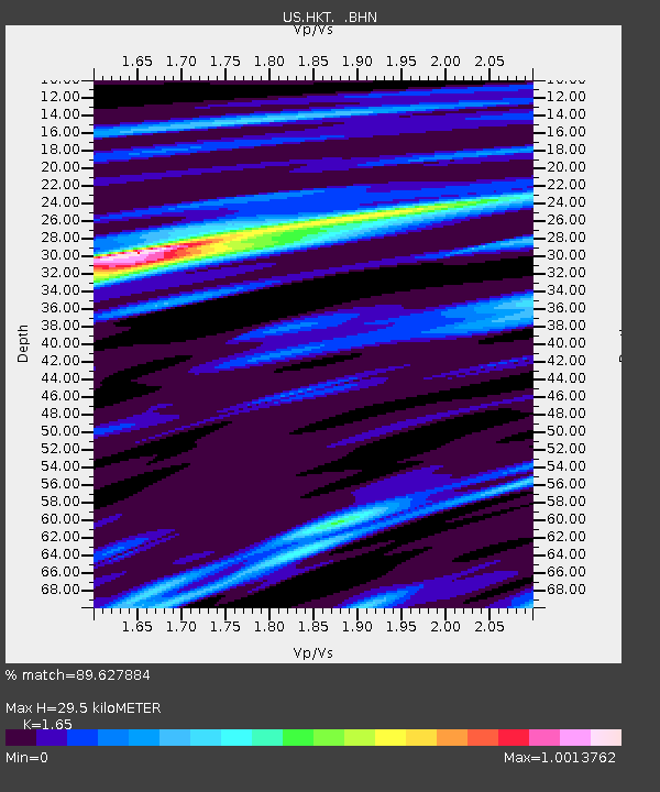
| Estimated Moho Depth: |
29.5 km |
| Estimated Crust Vp/Vs: |
1.65 |
| Assumed Crust Vp: |
5.581 km/s |
| Estimated Crust Vs: |
3.383 km/s |
| Estimated Crust Poisson's Ratio: |
0.21 |
|
| Radial Match: |
89.627884 % |
| Radial Bump: |
388 |
| Transverse Match: |
82.7945 % |
| Transverse Bump: |
400 |
| SOD ConfigId: |
110177 |
| Insert Time: |
2010-03-05 07:06:54.895 +0000 |
| GWidth: |
2.5 |
| Max Bumps: |
400 |
| Tol: |
0.001 |
|

Signal To Noise
| Channel | StoN | STA | LTA |
| US:HKT: :BHN:20030615T19:34:44.058997Z | 1.2608075 | 8.031463E-8 | 6.3700945E-8 |
| US:HKT: :BHE:20030615T19:34:44.058997Z | 0.9309195 | 7.874842E-8 | 8.459209E-8 |
| US:HKT: :BHZ:20030615T19:34:44.058997Z | 2.659014 | 3.1626155E-7 | 1.1893941E-7 |
| Arrivals |
| Ps | 3.6 SECOND |
| PpPs | 14 SECOND |
| PsPs/PpSs | 17 SECOND |


