You are here: Home > Network List > US - United States National Seismic Network Stations List
> Station HKT Hockley, Texas, USA > Earthquake Result Viewer
HKT Hockley, Texas, USA - Earthquake Result Viewer
| Earthquake location: |
Queen Charlotte Islands Region |
| Earthquake latitude/longitude: |
54.7/-134.5 |
| Earthquake time(UTC): |
2003/07/12 (193) 23:01:38 GMT |
| Earthquake Depth: |
20 km |
| Earthquake Magnitude: |
5.3 MB, 5.7 MS, 6.0 MW, 6.0 MW |
| Earthquake Catalog/Contributor: |
WHDF/NEIC |
|
| Network: |
US United States National Seismic Network |
| Station: |
HKT Hockley, Texas, USA |
| Lat/Lon: |
29.95 N/95.83 W |
| Elevation: |
-415.0 m |
|
| Distance: |
37.0 deg |
| Az: |
115.891 deg |
| Baz: |
322.958 deg |
| Ray Param: |
0.07632874 |
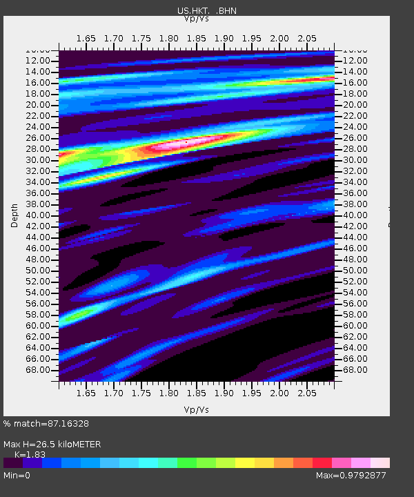
| Estimated Moho Depth: |
26.5 km |
| Estimated Crust Vp/Vs: |
1.83 |
| Assumed Crust Vp: |
5.581 km/s |
| Estimated Crust Vs: |
3.05 km/s |
| Estimated Crust Poisson's Ratio: |
0.29 |
|
| Radial Match: |
87.16328 % |
| Radial Bump: |
264 |
| Transverse Match: |
70.70858 % |
| Transverse Bump: |
400 |
| SOD ConfigId: |
110177 |
| Insert Time: |
2010-03-05 07:07:00.076 +0000 |
| GWidth: |
2.5 |
| Max Bumps: |
400 |
| Tol: |
0.001 |
|

Signal To Noise
| Channel | StoN | STA | LTA |
| US:HKT: :BHN:20030712T23:08:15.709015Z | 2.5591755 | 1.5325455E-7 | 5.988434E-8 |
| US:HKT: :BHE:20030712T23:08:15.709015Z | 0.6241039 | 3.0949533E-8 | 4.9590355E-8 |
| US:HKT: :BHZ:20030712T23:08:15.709015Z | 0.9738751 | 8.325545E-8 | 8.5488836E-8 |
| Arrivals |
| Ps | 4.2 SECOND |
| PpPs | 13 SECOND |
| PsPs/PpSs | 17 SECOND |


