You are here: Home > Network List > US - United States National Seismic Network Stations List
> Station CEH Chapel Hill, North Carolina, USA > Earthquake Result Viewer
CEH Chapel Hill, North Carolina, USA - Earthquake Result Viewer
| Earthquake location: |
Central Mid-Atlantic Ridge |
| Earthquake latitude/longitude: |
-0.9/-22.0 |
| Earthquake time(UTC): |
1995/05/18 (138) 00:06:26 GMT |
| Earthquake Depth: |
10 km |
| Earthquake Magnitude: |
6.2 MB, 6.1 MS, 6.8 UNKNOWN, 6.7 MW |
| Earthquake Catalog/Contributor: |
WHDF/NEIC |
|
| Network: |
US United States National Seismic Network |
| Station: |
CEH Chapel Hill, North Carolina, USA |
| Lat/Lon: |
35.89 N/79.09 W |
| Elevation: |
152 m |
|
| Distance: |
64.5 deg |
| Az: |
310.911 deg |
| Baz: |
111.475 deg |
| Ray Param: |
0.05891401 |
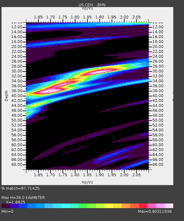
| Estimated Moho Depth: |
38.0 km |
| Estimated Crust Vp/Vs: |
1.69 |
| Assumed Crust Vp: |
6.565 km/s |
| Estimated Crust Vs: |
3.879 km/s |
| Estimated Crust Poisson's Ratio: |
0.23 |
|
| Radial Match: |
97.71425 % |
| Radial Bump: |
288 |
| Transverse Match: |
85.71085 % |
| Transverse Bump: |
400 |
| SOD ConfigId: |
110177 |
| Insert Time: |
2010-03-05 07:09:36.530 +0000 |
| GWidth: |
2.5 |
| Max Bumps: |
400 |
| Tol: |
0.001 |
|
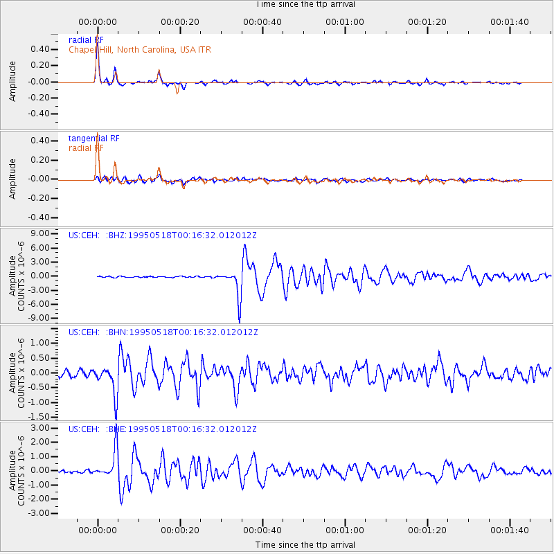
Signal To Noise
| Channel | StoN | STA | LTA |
| US:CEH: :BHN:19950518T00:16:32.012012Z | 5.729222 | 5.001869E-7 | 8.7304514E-8 |
| US:CEH: :BHE:19950518T00:16:32.012012Z | 16.040487 | 1.0465329E-6 | 6.524322E-8 |
| US:CEH: :BHZ:19950518T00:16:32.012012Z | 30.740776 | 3.076558E-6 | 1.0008068E-7 |
| Arrivals |
| Ps | 4.2 SECOND |
| PpPs | 15 SECOND |
| PsPs/PpSs | 19 SECOND |


