
Station US CEH - Chapel Hill, North Carolina, USA
Network: US - United States National Seismic Network
Nearby stations (2 deg radius)
| Station | Name | (Lat, Lon) | Start / End | Elevation |
| CEH | Chapel Hill, North Carolina, USA | (35.89, -79.09) | 1991-03-29 / 2001-02-26 | 152 m |
| Crust2 Type: | DG,thin Platform 1 km seds. |
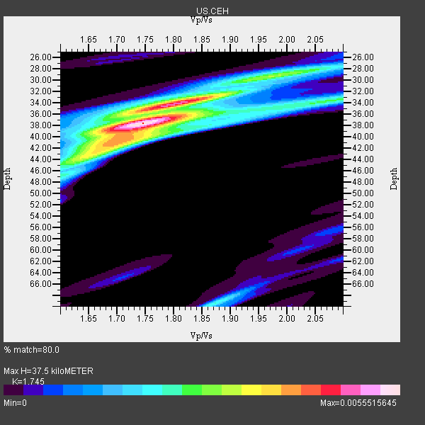
| Thickness Estimate: | 38 km |
| Thickness StdDev: | 6.2 km |
| Vp/Vs Estimate: | 1.75 |
| Vp/Vs StdDev: | 0.08 |
| Vs Estimate: | 3.762 km/s |
| Poisson's Ratio: | 0.26 |
| Peak Value: | 0.01 |
| Assumed Vp: | 6.565 km/s |
| Ps Weight: | 0.33333334 |
| PpPs Weight: | 0.33333334 |
| PsPs Weight: | 0.33333328 |
| Residual Complexity: | 0.626 |
| Nearby stations H: | +- |
| (2.0 deg) Vp/Vs: | +- |
7 with match > 90% ( 63.636364 %) and 7 with match > 80% ( 63.636364 %) out of 11.
Download stack as xyz text file.
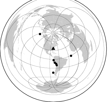
Azimuth Distribution of Events:
Prior Results for this Station
| Study | Thickness | Vp/Vs | Vp | Vs | Poissons Ratio | Extra |
| EARS | 38 km | 1.75 | 6.565 km/s | 3.762 km/s | 0.26 | |
| Crust2.0 | 31 km | 1.78 | 6.565 km/s | 3.684 km/s | 0.27 | DG,thin Platform 1 km seds. |
| Zandt Ammon | 33 km | 1.74 | 6.0 km/s | 3.448 km/s | 0.25 | |
| Zandt Ammon | 34 km | 1.73 | 6.25 km/s | 3.613 km/s | 0.25 | |
| Zandt Ammon | 36 km | 1.72 | 6.5 km/s | 3.779 km/s | 0.24 | |
| Zandt Ammon | 37 km | 1.71 | 6.75 km/s | 3.947 km/s | 0.24 | |
| Global Maxima | 38 km | 1.75 | 6.565 km/s | 3.762 km/s | 0.26 | amp=0.0055515645 |
| Local Maxima 1 | 34 km | 1.81 | 6.565 km/s | 3.632 km/s | 0.28 | amp=0.0039962325 |
| Local Maxima 2 | 29 km | 1.99 | 6.565 km/s | 3.299 km/s | 0.33 | amp=0.0026050243 |
| Local Maxima 3 | 42 km | 1.67 | 6.565 km/s | 3.937 km/s | 0.22 | amp=0.002391099 |
| Local Maxima 4 | 69 km | 1.87 | 6.565 km/s | 3.506 km/s | 0.30 | amp=0.0022221415 |
| Predicted Arrivals for vertical incidence (zero ray parameter) | |
| Ps | 4.26 SECOND |
| PpPs | 15.68 SECOND |
| PsPs/PpSs | 19.94 SECOND |
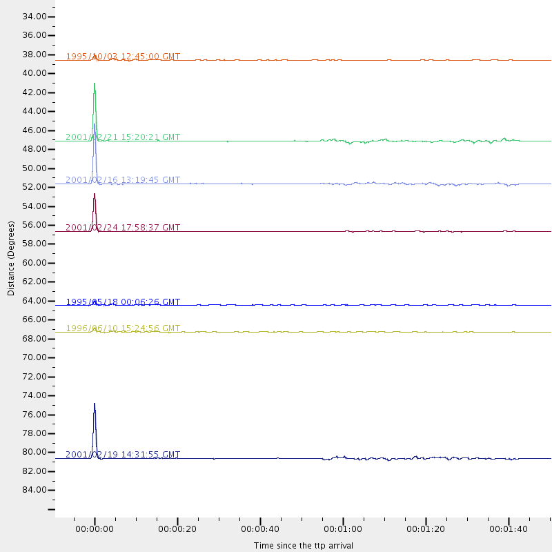
Events Processed for this Station
Download zip of receiver functions as SAC
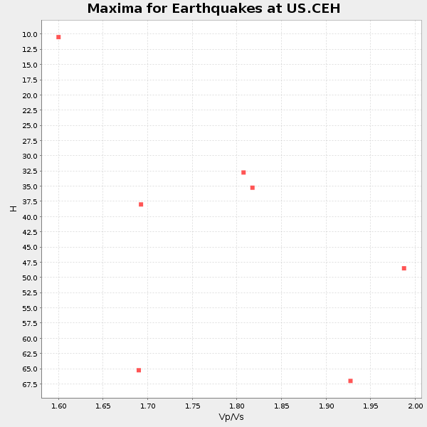
Plot maxima for each earthquake.
Events Used in the Stack
(7 events)| Radial Match | Distance | Baz | FERegion | Time | Lat/Lon | Depth | Magnitude |
| 99.1072 | 56.6 deg | 168.282 deg | Chile-Bolivia Border Region | 2001/02/24 17:58:37 GMT | (-20.2, -68.7) | 116 km | 5.3 MB, 5.8 MW |
| 98.36719 | 67.2 deg | 317.779 deg | Andreanof Islands, Aleutian Is. | 1996/06/10 15:24:56 GMT | (51.5, -176.8) | 26 km | 5.9 MB, 7.1 MS, 7.2 UNKNOWN, 6.9 MS |
| 97.71425 | 64.5 deg | 111.475 deg | Central Mid-Atlantic Ridge | 1995/05/18 00:06:26 GMT | (-0.9, -22.0) | 10 km | 6.2 MB, 6.1 MS, 6.8 UNKNOWN, 6.7 MW |
| 97.13644 | 51.6 deg | 169.37 deg | Southern Peru | 2001/02/16 13:19:45 GMT | (-15.3, -70.5) | 210 km | 5.1 MB, 5.5 MW |
| 97.12583 | 80.6 deg | 180.137 deg | Off Coast Of Southern Chile | 2001/02/19 14:31:55 GMT | (-45.1, -79.3) | 10 km | 5.1 MB, 5.2 MS, 5.8 MW |
| 96.725685 | 47.1 deg | 173.864 deg | Central Peru | 2001/02/21 15:20:21 GMT | (-11.3, -74.5) | 33 km | 5.5 MB, 5.2 MS, 5.8 MW, 5.8 MW |
| 91.527725 | 38.5 deg | 178.082 deg | Peru-Ecuador Border Region | 1995/10/03 12:45:00 GMT | (-2.8, -77.9) | 33 km | 6.0 MB, 6.1 MS, 5.9 UNKNOWN, 6.4 MW |
Losers
(4 events)| Radial Match | Distance | Baz | FERegion | Time | Lat/Lon | Depth | Magnitude | Reason |
| 75.2043 | 83.2 deg | 327.601 deg | Kuril Islands | 1995/06/29 07:45:09 GMT | (48.8, 154.5) | 62 km | 5.9 MB, 6.0 UNKNOWN, 6.0 MW | |
| 72.710175 | 38.5 deg | 177.989 deg | Peru-Ecuador Border Region | 1995/10/07 21:28:06 GMT | (-2.8, -77.8) | 33 km | 5.8 MB, 5.2 MS, 5.8 UNKNOWN | |
| 69.37239 | 38.3 deg | 177.902 deg | Peru-Ecuador Border Region | 1995/10/03 01:57:03 GMT | (-2.6, -77.8) | 33 km | 5.6 MB | |
| 40.536385 | 92.2 deg | 330.014 deg | Hokkaido, Japan Region | 1999/05/12 17:59:22 GMT | (43.0, 143.8) | 103 km | 5.9 MB, 6.2 MW, 6.1 MW |
