You are here: Home > Network List > US - United States National Seismic Network Stations List
> Station CEH Chapel Hill, North Carolina, USA > Earthquake Result Viewer
CEH Chapel Hill, North Carolina, USA - Earthquake Result Viewer
| Earthquake location: |
Chile-Bolivia Border Region |
| Earthquake latitude/longitude: |
-20.2/-68.7 |
| Earthquake time(UTC): |
2001/02/24 (055) 17:58:37 GMT |
| Earthquake Depth: |
116 km |
| Earthquake Magnitude: |
5.3 MB, 5.8 MW |
| Earthquake Catalog/Contributor: |
WHDF/NEIC |
|
| Network: |
US United States National Seismic Network |
| Station: |
CEH Chapel Hill, North Carolina, USA |
| Lat/Lon: |
35.89 N/79.09 W |
| Elevation: |
152 m |
|
| Distance: |
56.6 deg |
| Az: |
349.889 deg |
| Baz: |
168.282 deg |
| Ray Param: |
0.063658096 |
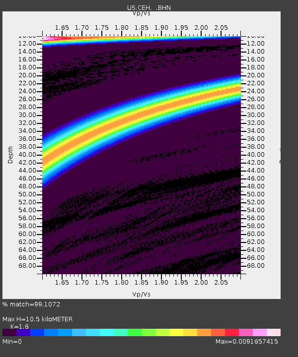
| Estimated Moho Depth: |
10.5 km |
| Estimated Crust Vp/Vs: |
1.60 |
| Assumed Crust Vp: |
6.565 km/s |
| Estimated Crust Vs: |
4.103 km/s |
| Estimated Crust Poisson's Ratio: |
0.18 |
|
| Radial Match: |
99.1072 % |
| Radial Bump: |
48 |
| Transverse Match: |
87.69088 % |
| Transverse Bump: |
150 |
| SOD ConfigId: |
110165 |
| Insert Time: |
2010-03-05 07:09:41.489 +0000 |
| GWidth: |
2.5 |
| Max Bumps: |
400 |
| Tol: |
0.001 |
|
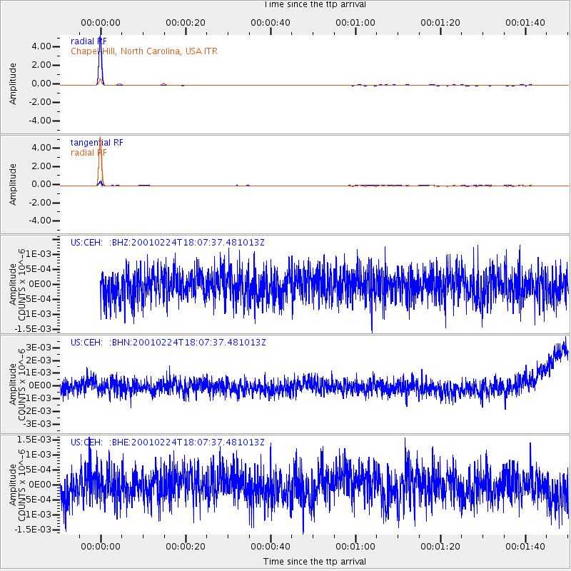
Signal To Noise
| Channel | StoN | STA | LTA |
| US:CEH: :BHN:20010224T18:07:37.481013Z | 1.0754898 | 5.08038E-10 | 4.7237825E-10 |
| US:CEH: :BHE:20010224T18:07:37.481013Z | 1.0339652 | 4.831456E-10 | 4.6727455E-10 |
| US:CEH: :BHZ:20010224T18:07:37.481013Z | 1.1092712 | 4.766427E-10 | 4.2968998E-10 |
| Arrivals |
| Ps | 1.0 SECOND |
| PpPs | 3.9 SECOND |
| PsPs/PpSs | 4.9 SECOND |


