You are here: Home > Network List > US - United States National Seismic Network Stations List
> Station CEH Chapel Hill, North Carolina, USA > Earthquake Result Viewer
CEH Chapel Hill, North Carolina, USA - Earthquake Result Viewer
| Earthquake location: |
Central Peru |
| Earthquake latitude/longitude: |
-11.3/-74.5 |
| Earthquake time(UTC): |
2001/02/21 (052) 15:20:21 GMT |
| Earthquake Depth: |
33 km |
| Earthquake Magnitude: |
5.5 MB, 5.2 MS, 5.8 MW, 5.8 MW |
| Earthquake Catalog/Contributor: |
WHDF/NEIC |
|
| Network: |
US United States National Seismic Network |
| Station: |
CEH Chapel Hill, North Carolina, USA |
| Lat/Lon: |
35.89 N/79.09 W |
| Elevation: |
152 m |
|
| Distance: |
47.1 deg |
| Az: |
354.924 deg |
| Baz: |
173.864 deg |
| Ray Param: |
0.070141345 |
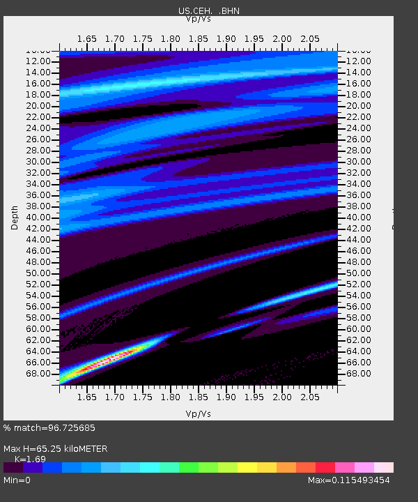
| Estimated Moho Depth: |
65.25 km |
| Estimated Crust Vp/Vs: |
1.69 |
| Assumed Crust Vp: |
6.565 km/s |
| Estimated Crust Vs: |
3.884 km/s |
| Estimated Crust Poisson's Ratio: |
0.23 |
|
| Radial Match: |
96.725685 % |
| Radial Bump: |
77 |
| Transverse Match: |
95.04197 % |
| Transverse Bump: |
120 |
| SOD ConfigId: |
110165 |
| Insert Time: |
2010-03-05 07:09:42.735 +0000 |
| GWidth: |
2.5 |
| Max Bumps: |
400 |
| Tol: |
0.001 |
|
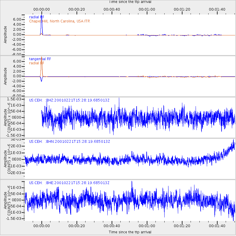
Signal To Noise
| Channel | StoN | STA | LTA |
| US:CEH: :BHN:20010221T15:28:19.685013Z | 1.0462894 | 4.082949E-10 | 3.902313E-10 |
| US:CEH: :BHE:20010221T15:28:19.685013Z | 0.84005994 | 3.468365E-10 | 4.1287113E-10 |
| US:CEH: :BHZ:20010221T15:28:19.685013Z | 0.9654654 | 4.0923434E-10 | 4.238726E-10 |
| Arrivals |
| Ps | 7.3 SECOND |
| PpPs | 25 SECOND |
| PsPs/PpSs | 32 SECOND |


