You are here: Home > Network List > US - United States National Seismic Network Stations List
> Station CEH Chapel Hill, North Carolina, USA > Earthquake Result Viewer
CEH Chapel Hill, North Carolina, USA - Earthquake Result Viewer
| Earthquake location: |
Off Coast Of Southern Chile |
| Earthquake latitude/longitude: |
-45.1/-79.3 |
| Earthquake time(UTC): |
2001/02/19 (050) 14:31:55 GMT |
| Earthquake Depth: |
10 km |
| Earthquake Magnitude: |
5.1 MB, 5.2 MS, 5.8 MW |
| Earthquake Catalog/Contributor: |
WHDF/NEIC |
|
| Network: |
US United States National Seismic Network |
| Station: |
CEH Chapel Hill, North Carolina, USA |
| Lat/Lon: |
35.89 N/79.09 W |
| Elevation: |
152 m |
|
| Distance: |
80.6 deg |
| Az: |
0.157 deg |
| Baz: |
180.137 deg |
| Ray Param: |
0.04815727 |
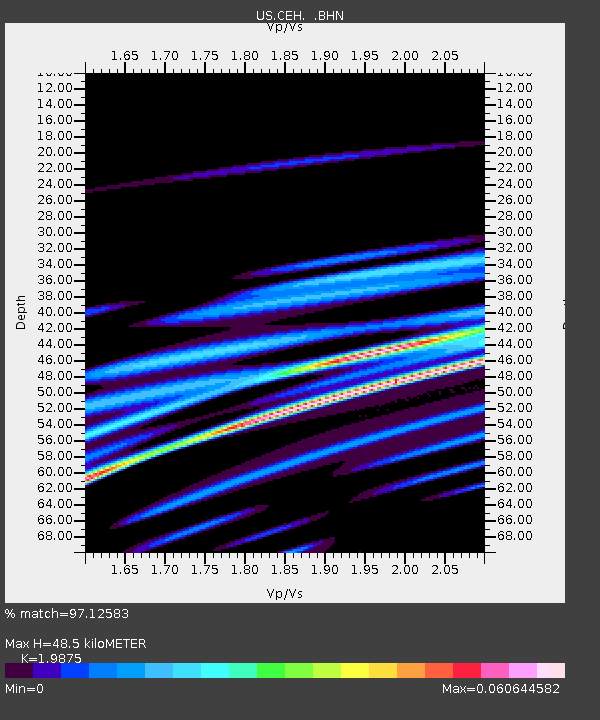
| Estimated Moho Depth: |
48.5 km |
| Estimated Crust Vp/Vs: |
1.99 |
| Assumed Crust Vp: |
6.565 km/s |
| Estimated Crust Vs: |
3.303 km/s |
| Estimated Crust Poisson's Ratio: |
0.33 |
|
| Radial Match: |
97.12583 % |
| Radial Bump: |
87 |
| Transverse Match: |
95.65403 % |
| Transverse Bump: |
111 |
| SOD ConfigId: |
110165 |
| Insert Time: |
2010-03-05 07:09:43.841 +0000 |
| GWidth: |
2.5 |
| Max Bumps: |
400 |
| Tol: |
0.001 |
|
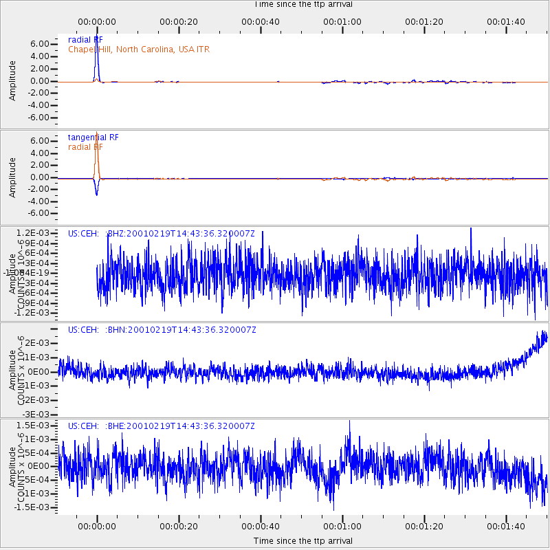
Signal To Noise
| Channel | StoN | STA | LTA |
| US:CEH: :BHN:20010219T14:43:36.320007Z | 0.6940584 | 3.186988E-10 | 4.591815E-10 |
| US:CEH: :BHE:20010219T14:43:36.320007Z | 1.0258077 | 4.7459875E-10 | 4.6265855E-10 |
| US:CEH: :BHZ:20010219T14:43:36.320007Z | 1.1538692 | 4.8439347E-10 | 4.197993E-10 |
| Arrivals |
| Ps | 7.5 SECOND |
| PpPs | 22 SECOND |
| PsPs/PpSs | 29 SECOND |


