You are here: Home > Network List > US - United States National Seismic Network Stations List
> Station CEH Chapel Hill, North Carolina, USA > Earthquake Result Viewer
CEH Chapel Hill, North Carolina, USA - Earthquake Result Viewer
| Earthquake location: |
Southern Peru |
| Earthquake latitude/longitude: |
-15.3/-70.5 |
| Earthquake time(UTC): |
2001/02/16 (047) 13:19:45 GMT |
| Earthquake Depth: |
210 km |
| Earthquake Magnitude: |
5.1 MB, 5.5 MW |
| Earthquake Catalog/Contributor: |
WHDF/NEIC |
|
| Network: |
US United States National Seismic Network |
| Station: |
CEH Chapel Hill, North Carolina, USA |
| Lat/Lon: |
35.89 N/79.09 W |
| Elevation: |
152 m |
|
| Distance: |
51.6 deg |
| Az: |
351.069 deg |
| Baz: |
169.37 deg |
| Ray Param: |
0.06654873 |
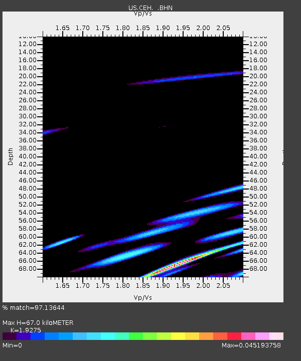
| Estimated Moho Depth: |
67.0 km |
| Estimated Crust Vp/Vs: |
1.93 |
| Assumed Crust Vp: |
6.565 km/s |
| Estimated Crust Vs: |
3.406 km/s |
| Estimated Crust Poisson's Ratio: |
0.32 |
|
| Radial Match: |
97.13644 % |
| Radial Bump: |
85 |
| Transverse Match: |
92.87539 % |
| Transverse Bump: |
140 |
| SOD ConfigId: |
110165 |
| Insert Time: |
2010-03-05 07:09:44.998 +0000 |
| GWidth: |
2.5 |
| Max Bumps: |
400 |
| Tol: |
0.001 |
|
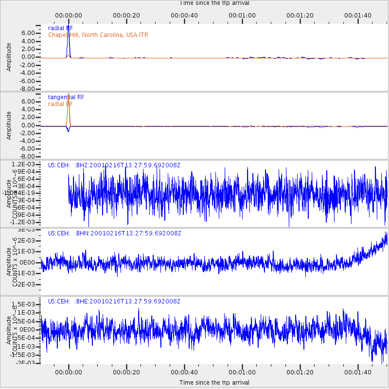
Signal To Noise
| Channel | StoN | STA | LTA |
| US:CEH: :BHN:20010216T13:27:59.692008Z | 0.9504622 | 3.5707756E-10 | 3.7568834E-10 |
| US:CEH: :BHE:20010216T13:27:59.692008Z | 0.9159005 | 3.9801917E-10 | 4.3456594E-10 |
| US:CEH: :BHZ:20010216T13:27:59.692008Z | 1.1344639 | 4.736203E-10 | 4.1748383E-10 |
| Arrivals |
| Ps | 10.0 SECOND |
| PpPs | 28 SECOND |
| PsPs/PpSs | 38 SECOND |


