You are here: Home > Network List > US - United States National Seismic Network Stations List
> Station CEH Chapel Hill, North Carolina, USA > Earthquake Result Viewer
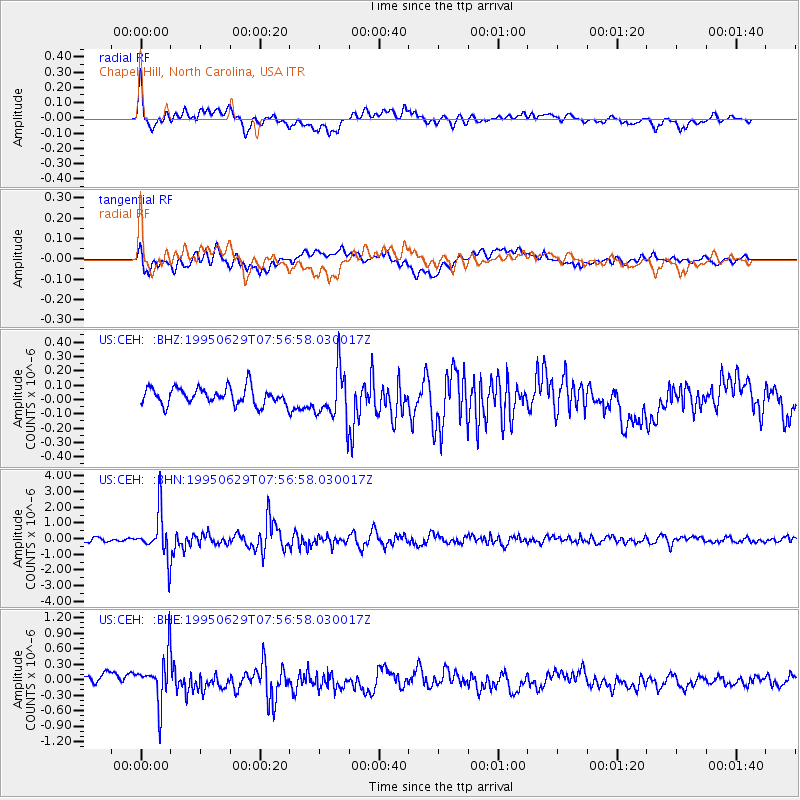
CEH Chapel Hill, North Carolina, USA - Earthquake Result Viewer
*The percent match for this event was below the threshold and hence no stack was calculated.
| Earthquake location: |
Kuril Islands |
| Earthquake latitude/longitude: |
48.8/154.5 |
| Earthquake time(UTC): |
1995/06/29 (180) 07:45:09 GMT |
| Earthquake Depth: |
62 km |
| Earthquake Magnitude: |
5.9 MB, 6.0 UNKNOWN, 6.0 MW |
| Earthquake Catalog/Contributor: |
WHDF/NEIC |
|
| Network: |
US United States National Seismic Network |
| Station: |
CEH Chapel Hill, North Carolina, USA |
| Lat/Lon: |
35.89 N/79.09 W |
| Elevation: |
152 m |
|
| Distance: |
83.2 deg |
| Az: |
41.134 deg |
| Baz: |
327.601 deg |
| Ray Param: |
$rayparam |
*The percent match for this event was below the threshold and hence was not used in the summary stack. |
|
| Radial Match: |
75.2043 % |
| Radial Bump: |
400 |
| Transverse Match: |
82.24114 % |
| Transverse Bump: |
400 |
| SOD ConfigId: |
4480 |
| Insert Time: |
2010-03-05 07:09:46.727 +0000 |
| GWidth: |
2.5 |
| Max Bumps: |
400 |
| Tol: |
0.001 |
|
Signal To Noise
| Channel | StoN | STA | LTA |
| US:CEH: :BHN:19950629T07:56:58.030017Z | 10.347215 | 1.4060436E-6 | 1.358862E-7 |
| US:CEH: :BHE:19950629T07:56:58.030017Z | 4.350817 | 4.6129327E-7 | 1.0602451E-7 |
| US:CEH: :BHZ:19950629T07:56:58.030017Z | 2.918452 | 1.7420804E-7 | 5.969193E-8 |
| Arrivals |
| Ps | |
| PpPs | |
| PsPs/PpSs | |


