You are here: Home > Network List > US - United States National Seismic Network Stations List
> Station CEH Chapel Hill, North Carolina, USA > Earthquake Result Viewer
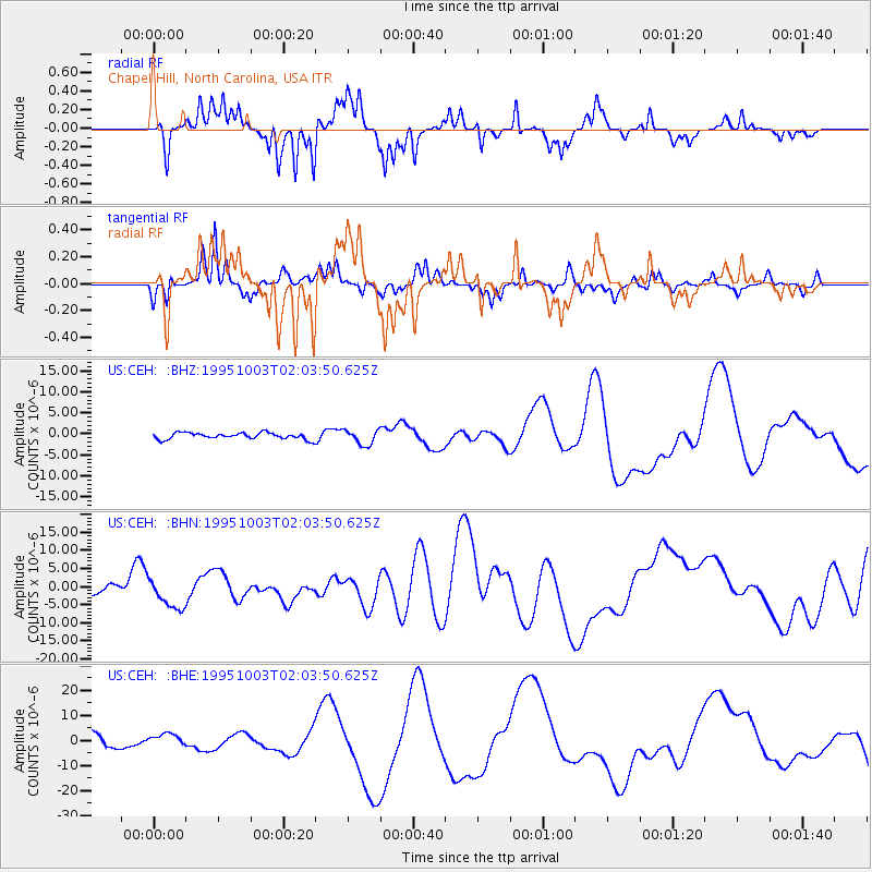
CEH Chapel Hill, North Carolina, USA - Earthquake Result Viewer
*The percent match for this event was below the threshold and hence no stack was calculated.
| Earthquake location: |
Peru-Ecuador Border Region |
| Earthquake latitude/longitude: |
-2.6/-77.8 |
| Earthquake time(UTC): |
1995/10/03 (276) 01:57:03 GMT |
| Earthquake Depth: |
33 km |
| Earthquake Magnitude: |
5.6 MB |
| Earthquake Catalog/Contributor: |
WHDF/NEIC |
|
| Network: |
US United States National Seismic Network |
| Station: |
CEH Chapel Hill, North Carolina, USA |
| Lat/Lon: |
35.89 N/79.09 W |
| Elevation: |
152 m |
|
| Distance: |
38.3 deg |
| Az: |
358.295 deg |
| Baz: |
177.902 deg |
| Ray Param: |
$rayparam |
*The percent match for this event was below the threshold and hence was not used in the summary stack. |
|
| Radial Match: |
69.37239 % |
| Radial Bump: |
301 |
| Transverse Match: |
47.91343 % |
| Transverse Bump: |
313 |
| SOD ConfigId: |
4480 |
| Insert Time: |
2010-03-05 07:09:48.388 +0000 |
| GWidth: |
2.5 |
| Max Bumps: |
400 |
| Tol: |
0.001 |
|
Signal To Noise
| Channel | StoN | STA | LTA |
| US:CEH: :BHN:19951003T02:03:50.625Z | 2.5296075 | 4.326847E-6 | 1.7104816E-6 |
| US:CEH: :BHE:19951003T02:03:50.625Z | 1.0761436 | 2.5843733E-6 | 2.4015135E-6 |
| US:CEH: :BHZ:19951003T02:03:50.625Z | 2.405602 | 1.7895313E-6 | 7.4390164E-7 |
| Arrivals |
| Ps | |
| PpPs | |
| PsPs/PpSs | |


