You are here: Home > Network List > TA - USArray Transportable Network (new EarthScope stations) Stations List
> Station L02F Cave Junction, OR, USA > Earthquake Result Viewer
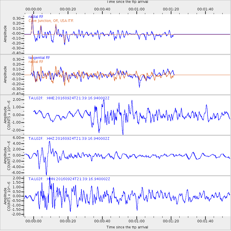
L02F Cave Junction, OR, USA - Earthquake Result Viewer
*The percent match for this event was below the threshold and hence no stack was calculated.
| Earthquake location: |
Fiji Islands Region |
| Earthquake latitude/longitude: |
-19.8/-178.3 |
| Earthquake time(UTC): |
2016/09/24 (268) 21:28:42 GMT |
| Earthquake Depth: |
594 km |
| Earthquake Magnitude: |
6.8 MO |
| Earthquake Catalog/Contributor: |
NEIC PDE/NEIC ALERT |
|
| Network: |
TA USArray Transportable Network (new EarthScope stations) |
| Station: |
L02F Cave Junction, OR, USA |
| Lat/Lon: |
42.12 N/123.57 W |
| Elevation: |
440 m |
|
| Distance: |
79.7 deg |
| Az: |
38.11 deg |
| Baz: |
231.347 deg |
| Ray Param: |
$rayparam |
*The percent match for this event was below the threshold and hence was not used in the summary stack. |
|
| Radial Match: |
74.89523 % |
| Radial Bump: |
400 |
| Transverse Match: |
59.921165 % |
| Transverse Bump: |
400 |
| SOD ConfigId: |
11737051 |
| Insert Time: |
2019-04-25 15:23:58.340 +0000 |
| GWidth: |
2.5 |
| Max Bumps: |
400 |
| Tol: |
0.001 |
|
Signal To Noise
| Channel | StoN | STA | LTA |
| TA:L02F: :HHZ:20160924T21:39:16.940002Z | 5.112409 | 1.6502534E-6 | 3.2279368E-7 |
| TA:L02F: :HHN:20160924T21:39:16.940002Z | 1.4311976 | 5.656932E-7 | 3.952586E-7 |
| TA:L02F: :HHE:20160924T21:39:16.940002Z | 1.9368944 | 7.1742664E-7 | 3.7040047E-7 |
| Arrivals |
| Ps | |
| PpPs | |
| PsPs/PpSs | |


