You are here: Home > Network List > BK - Berkeley Digital Seismograph Network Stations List
> Station GASB Alder Springs, CA, USA > Earthquake Result Viewer
GASB Alder Springs, CA, USA - Earthquake Result Viewer
| Earthquake location: |
South Of Fiji Islands |
| Earthquake latitude/longitude: |
-25.8/179.5 |
| Earthquake time(UTC): |
2007/10/16 (289) 21:05:43 GMT |
| Earthquake Depth: |
509 km |
| Earthquake Magnitude: |
6.2 MB, 6.6 MW, 6.5 MW |
| Earthquake Catalog/Contributor: |
WHDF/NEIC |
|
| Network: |
BK Berkeley Digital Seismograph Network |
| Station: |
GASB Alder Springs, CA, USA |
| Lat/Lon: |
39.65 N/122.72 W |
| Elevation: |
1355 m |
|
| Distance: |
84.5 deg |
| Az: |
40.995 deg |
| Baz: |
230.01 deg |
| Ray Param: |
0.044028763 |
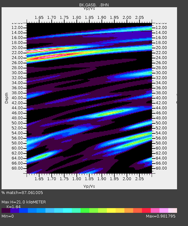
| Estimated Moho Depth: |
21.0 km |
| Estimated Crust Vp/Vs: |
1.64 |
| Assumed Crust Vp: |
6.472 km/s |
| Estimated Crust Vs: |
3.946 km/s |
| Estimated Crust Poisson's Ratio: |
0.20 |
|
| Radial Match: |
87.061005 % |
| Radial Bump: |
400 |
| Transverse Match: |
86.26258 % |
| Transverse Bump: |
400 |
| SOD ConfigId: |
2564 |
| Insert Time: |
2010-03-05 19:17:44.650 +0000 |
| GWidth: |
2.5 |
| Max Bumps: |
400 |
| Tol: |
0.001 |
|

Signal To Noise
| Channel | StoN | STA | LTA |
| BK:GASB: :BHN:20071016T21:16:50.650005Z | 3.5027971 | 1.3004637E-6 | 3.7126435E-7 |
| BK:GASB: :BHE:20071016T21:16:50.650005Z | 3.8350222 | 1.5688726E-6 | 4.0909086E-7 |
| BK:GASB: :BHZ:20071016T21:16:50.650005Z | 29.516708 | 6.727495E-6 | 2.2792159E-7 |
| Arrivals |
| Ps | 2.1 SECOND |
| PpPs | 8.4 SECOND |
| PsPs/PpSs | 10 SECOND |


