
Station BK GASB - Alder Springs, CA, USA
Network: BK - Berkeley Digital Seismograph Network
Nearby stations (2 deg radius)
| Station | Name | (Lat, Lon) | Start / End | Elevation |
| GASB | Alder Springs, CA, USA | (39.65, -122.72) | 2005-09-22 / 2499-01-01 | 1355 m |
| Crust2 Type: | T6,Margin /shield transition, 1 km seds. |
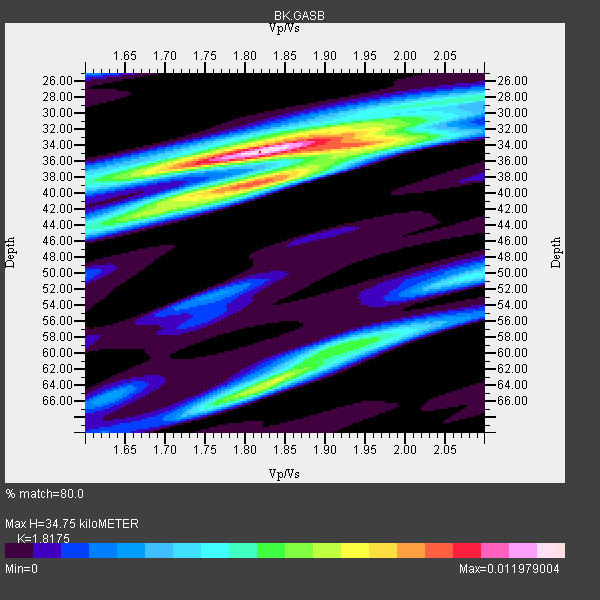
| Thickness Estimate: | 35 km |
| Thickness StdDev: | 5.5 km |
| Vp/Vs Estimate: | 1.82 |
| Vp/Vs StdDev: | 0.06 |
| Vs Estimate: | 3.561 km/s |
| Poisson's Ratio: | 0.28 |
| Peak Value: | 0.01 |
| Assumed Vp: | 6.472 km/s |
| Ps Weight: | 0.33333334 |
| PpPs Weight: | 0.33333334 |
| PsPs Weight: | 0.33333328 |
| Residual Complexity: | 0.691 |
| Nearby stations H: | +- |
| (2.0 deg) Vp/Vs: | +- |
22 with match > 90% ( 48.88889 %) and 45 with match > 80% ( 100.0 %) out of 45.
Download stack as xyz text file.
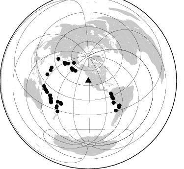
Azimuth Distribution of Events:
Prior Results for this Station
| Study | Thickness | Vp/Vs | Vp | Vs | Poissons Ratio | Extra |
| EARS | 35 km | 1.82 | 6.472 km/s | 3.561 km/s | 0.28 | |
| Crust2.0 | 32 km | 1.79 | 6.472 km/s | 3.622 km/s | 0.27 | T6,Margin /shield transition, 1 km seds. |
| Global Maxima | 35 km | 1.82 | 6.472 km/s | 3.561 km/s | 0.28 | amp=0.011979004 |
| Local Maxima 1 | 38 km | 1.83 | 6.472 km/s | 3.546 km/s | 0.29 | amp=0.008567488 |
| Local Maxima 2 | 63 km | 1.84 | 6.472 km/s | 3.517 km/s | 0.29 | amp=0.007413648 |
| Local Maxima 3 | 34 km | 1.97 | 6.472 km/s | 3.289 km/s | 0.33 | amp=0.00572108 |
| Local Maxima 4 | 58 km | 1.95 | 6.472 km/s | 3.327 km/s | 0.32 | amp=0.005367959 |
| Predicted Arrivals for vertical incidence (zero ray parameter) | |
| Ps | 4.39 SECOND |
| PpPs | 15.13 SECOND |
| PsPs/PpSs | 19.52 SECOND |
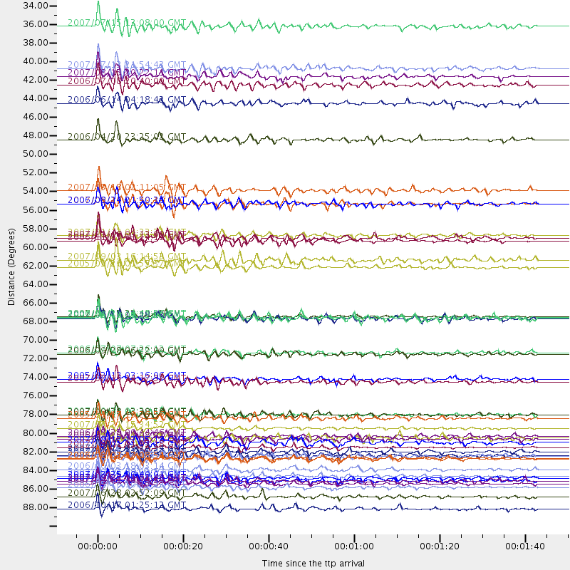
Events Processed for this Station
Download zip of receiver functions as SAC
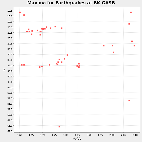
Plot maxima for each earthquake.
Events Used in the Stack
(45 events)| Radial Match | Distance | Baz | FERegion | Time | Lat/Lon | Depth | Magnitude |
| 97.534 | 59.0 deg | 306.815 deg | Kuril Islands | 2006/11/15 11:14:13 GMT | (46.6, 153.3) | 10 km | 6.5 MB, 7.8 MS, 8.3 MW, 7.9 MW |
| 96.69096 | 83.5 deg | 249.268 deg | Santa Cruz Islands | 2007/09/02 01:05:18 GMT | (-11.6, 165.8) | 35 km | 5.9 MB, 7.3 MS, 7.2 MW, 6.9 ME |
| 95.934906 | 68.0 deg | 130.847 deg | Near Coast Of Peru | 2007/08/15 23:40:57 GMT | (-13.4, -76.6) | 39 km | 6.7 MB, 7.9 MS, 8.0 MW, 7.5 ME |
| 95.27015 | 62.1 deg | 125.468 deg | Northern Peru | 2005/09/26 01:55:37 GMT | (-5.7, -76.4) | 115 km | 6.7 MB, 7.5 MW, 7.5 MW |
| 95.033966 | 84.1 deg | 244.618 deg | Vanuatu Islands | 2007/07/15 09:27:34 GMT | (-15.4, 168.6) | 8.0 km | 6.0 MB, 5.8 MS, 6.1 MW, 6.0 MW |
| 93.82916 | 80.1 deg | 129.794 deg | Chile-Bolivia Border Region | 2005/11/17 19:26:56 GMT | (-22.3, -67.9) | 163 km | 6.0 MB, 6.9 MW, 6.8 MW |
| 93.80067 | 58.3 deg | 306.0 deg | East Of Kuril Islands | 2007/01/13 04:23:21 GMT | (46.2, 154.5) | 10 km | 7.3 MB, 8.2 MS, 8.1 MW, 7.9 MW |
| 93.27892 | 54.5 deg | 120.305 deg | Near West Coast Of Colombia | 2007/09/10 01:49:14 GMT | (3.0, -78.0) | 31 km | 6.1 MB, 6.7 MS, 6.8 MW |
| 93.19332 | 47.0 deg | 321.079 deg | Eastern Siberia, Russia | 2006/04/20 23:25:02 GMT | (60.9, 167.1) | 22 km | 6.8 MB, 7.6 MS, 7.6 MW, 7.3 MW |
| 93.01612 | 88.3 deg | 225.339 deg | Kermadec Islands Region | 2006/05/16 10:39:23 GMT | (-31.8, -179.3) | 152 km | 6.8 MB, 7.4 MW, 7.4 MW |
| 92.816605 | 75.4 deg | 235.63 deg | Fiji Islands Region | 2005/12/13 03:16:06 GMT | (-15.3, -178.6) | 10 km | 6.1 MB, 6.8 MS, 6.7 MW, 6.7 MW |
| 92.78627 | 87.9 deg | 257.316 deg | Solomon Islands | 2007/04/01 20:39:56 GMT | (-8.5, 157.0) | 10 km | 6.8 MB, 7.9 MS, 8.1 MW, 7.7 ME |
| 92.03167 | 72.4 deg | 229.712 deg | Samoa Islands Region | 2006/09/28 06:22:09 GMT | (-16.6, -172.0) | 28 km | 6.5 MB, 6.6 MS, 6.9 MW, 6.7 MW |
| 91.994514 | 87.0 deg | 254.722 deg | Solomon Islands | 2007/08/16 08:39:27 GMT | (-9.8, 159.5) | 10 km | 6.1 MB, 6.7 MS, 6.4 MW |
| 91.47892 | 84.9 deg | 245.077 deg | Vanuatu Islands | 2007/08/01 17:08:51 GMT | (-15.6, 167.7) | 120 km | 6.2 MB, 7.2 MW, 7.2 MW |
| 91.17227 | 86.2 deg | 241.84 deg | Vanuatu Islands | 2006/10/03 18:03:14 GMT | (-18.9, 169.0) | 171 km | 5.9 MB, 6.3 MW, 6.3 MW |
| 91.16898 | 84.9 deg | 244.866 deg | Vanuatu Islands | 2006/08/07 22:18:54 GMT | (-15.8, 167.8) | 141 km | 6.0 MB, 6.8 MW, 6.8 MW |
| 90.94094 | 79.7 deg | 289.921 deg | Volcano Islands, Japan Region | 2007/09/28 13:38:59 GMT | (22.0, 142.7) | 276 km | 6.7 MB, 7.4 MW, 7.4 MW |
| 90.89093 | 33.4 deg | 307.806 deg | Fox Islands, Aleutian Islands | 2007/07/15 13:08:00 GMT | (52.5, -168.0) | 10 km | 5.8 MB, 5.9 MS, 6.1 MW, 6.0 MW |
| 90.833595 | 87.6 deg | 240.059 deg | Southeast Of Loyalty Islands | 2007/09/27 19:57:44 GMT | (-21.1, 169.3) | 9.0 km | 6.2 MB, 6.3 MS, 6.1 MW, 6.1 MW |
| 90.609764 | 82.5 deg | 231.102 deg | South Of Fiji Islands | 2006/02/26 03:08:27 GMT | (-23.6, -180.0) | 535 km | 5.9 MB, 6.4 MW, 6.4 MW |
| 90.56504 | 84.6 deg | 279.03 deg | South Of Mariana Islands | 2007/09/30 02:08:30 GMT | (10.5, 145.7) | 14 km | 6.4 MB, 7.1 MS, 6.9 MW, 6.9 MW |
| 89.8559 | 75.8 deg | 306.046 deg | Sea Of Japan | 2007/07/16 14:17:37 GMT | (36.8, 134.9) | 350 km | 6.2 MB, 6.8 MW, 6.8 MW |
| 89.4108 | 38.5 deg | 306.637 deg | Andreanof Islands, Aleutian Is. | 2007/07/13 21:54:43 GMT | (51.8, -176.3) | 35 km | 5.7 MB, 5.6 MS, 6.0 MW, 5.9 MW |
| 89.26051 | 68.0 deg | 130.954 deg | Near Coast Of Peru | 2006/10/20 10:48:56 GMT | (-13.5, -76.7) | 23 km | 5.9 MB, 6.6 MS, 6.7 MW, 6.6 MW |
| 89.23223 | 53.0 deg | 119.471 deg | South Of Panama | 2007/03/18 02:11:05 GMT | (4.6, -78.5) | 8.0 km | 6.4 MB, 5.7 MS, 6.2 MW, 6.1 MW |
| 88.11972 | 87.2 deg | 240.358 deg | Vanuatu Islands | 2007/03/25 00:40:01 GMT | (-20.6, 169.4) | 34 km | 6.5 MB, 7.0 MS, 7.1 MW, 7.1 MW |
| 87.2989 | 89.4 deg | 259.232 deg | Solomon Islands | 2007/06/28 02:52:09 GMT | (-8.0, 154.6) | 10 km | 6.3 MB, 6.7 MS, 6.7 MW, 6.7 MW |
| 87.061005 | 84.5 deg | 230.01 deg | South Of Fiji Islands | 2007/10/16 21:05:43 GMT | (-25.8, 179.5) | 509 km | 6.2 MB, 6.6 MW, 6.5 MW |
| 86.9508 | 61.3 deg | 307.222 deg | Kuril Islands | 2007/09/03 16:14:53 GMT | (45.8, 150.1) | 94 km | 6.3 MB, 6.2 MW, 6.2 ME |
| 86.94765 | 40.4 deg | 305.9 deg | Andreanof Islands, Aleutian Is. | 2006/07/08 20:40:00 GMT | (51.2, -179.3) | 22 km | 6.2 MB, 6.4 MS, 6.6 MW, 6.6 MW |
| 86.64621 | 68.2 deg | 131.012 deg | Near Coast Of Peru | 2007/08/19 01:22:40 GMT | (-13.6, -76.6) | 26 km | 5.9 MB, 5.4 MS, 5.8 MW, 5.5 ML |
| 85.85351 | 39.4 deg | 304.331 deg | Andreanof Islands, Aleutian Is. | 2007/08/15 20:22:11 GMT | (50.3, -177.5) | 9.0 km | 6.3 MB, 6.2 MS, 6.4 MW, 5.9 ML |
| 85.7944 | 54.5 deg | 310.45 deg | Near East Coast Of Kamchatka | 2006/08/24 21:50:36 GMT | (51.1, 157.5) | 43 km | 5.9 MB, 6.2 MS, 6.5 MW, 6.5 MW |
| 85.639824 | 90.9 deg | 263.144 deg | New Britain Region, P.N.G. | 2006/10/17 01:25:12 GMT | (-5.9, 151.0) | 32 km | 6.4 MB, 6.9 MS, 6.7 MW, 6.6 MW |
| 85.30057 | 87.6 deg | 239.935 deg | Southeast Of Loyalty Islands | 2007/09/28 01:01:48 GMT | (-21.2, 169.4) | 10 km | 5.8 MB, 6.4 MS, 6.3 MW, 6.2 MW |
| 83.096954 | 82.5 deg | 137.126 deg | Off Coast Of Central Chile | 2006/07/16 11:42:41 GMT | (-28.7, -72.5) | 10 km | 5.9 MB, 5.7 MS, 6.2 MW, 6.2 MW |
| 82.9016 | 81.2 deg | 128.175 deg | Jujuy Province, Argentina | 2007/07/21 15:34:52 GMT | (-22.2, -65.8) | 290 km | 5.8 MB, 6.4 MW, 6.3 MW |
| 82.85954 | 83.0 deg | 249.097 deg | Santa Cruz Islands | 2007/08/12 12:05:19 GMT | (-11.4, 166.3) | 42 km | 5.8 MB, 5.7 MS, 6.0 MW, 6.0 MW |
| 82.317894 | 79.6 deg | 285.852 deg | Mariana Islands | 2007/10/31 03:30:17 GMT | (18.9, 145.4) | 223 km | 6.2 MB, 7.2 MW, 7.2 MW |
| 82.12408 | 82.2 deg | 130.531 deg | Chile-Argentina Border Region | 2006/08/25 00:44:46 GMT | (-24.4, -67.0) | 184 km | 5.9 MB, 6.6 MW, 6.6 MW |
| 82.0516 | 58.6 deg | 124.302 deg | Peru-Ecuador Border Region | 2007/11/16 03:13:00 GMT | (-2.3, -77.8) | 123 km | 6.3 MB, 6.8 MW, 6.7 MW |
| 81.21449 | 42.6 deg | 307.127 deg | Rat Islands, Aleutian Islands | 2006/06/14 04:18:42 GMT | (51.8, 177.1) | 14 km | 5.9 MB, 6.4 MS, 6.4 MW, 6.4 MW |
| 80.70023 | 68.2 deg | 130.985 deg | Near Coast Of Peru | 2007/08/17 13:18:13 GMT | (-13.6, -76.6) | 48 km | 5.6 MB, 5.6 MS, 5.9 MW |
| 80.56849 | 72.3 deg | 231.834 deg | Tonga Islands | 2006/07/07 07:26:12 GMT | (-15.2, -173.6) | 35 km | 5.7 MB, 5.9 MS, 6.0 MW, 6.0 MW |
Losers
(0 events)| Radial Match | Distance | Baz | FERegion | Time | Lat/Lon | Depth | Magnitude | Reason |
