You are here: Home > Network List > BK - Berkeley Digital Seismograph Network Stations List
> Station GASB Alder Springs, CA, USA > Earthquake Result Viewer
GASB Alder Springs, CA, USA - Earthquake Result Viewer
| Earthquake location: |
Kuril Islands |
| Earthquake latitude/longitude: |
45.8/150.1 |
| Earthquake time(UTC): |
2007/09/03 (246) 16:14:53 GMT |
| Earthquake Depth: |
94 km |
| Earthquake Magnitude: |
6.3 MB, 6.2 MW, 6.2 ME |
| Earthquake Catalog/Contributor: |
WHDF/NEIC |
|
| Network: |
BK Berkeley Digital Seismograph Network |
| Station: |
GASB Alder Springs, CA, USA |
| Lat/Lon: |
39.65 N/122.72 W |
| Elevation: |
1355 m |
|
| Distance: |
61.3 deg |
| Az: |
61.559 deg |
| Baz: |
307.222 deg |
| Ray Param: |
0.060725182 |
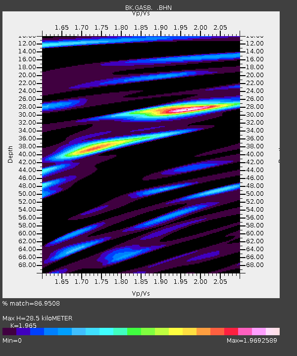
| Estimated Moho Depth: |
28.5 km |
| Estimated Crust Vp/Vs: |
1.97 |
| Assumed Crust Vp: |
6.472 km/s |
| Estimated Crust Vs: |
3.294 km/s |
| Estimated Crust Poisson's Ratio: |
0.33 |
|
| Radial Match: |
86.9508 % |
| Radial Bump: |
390 |
| Transverse Match: |
77.335396 % |
| Transverse Bump: |
400 |
| SOD ConfigId: |
2564 |
| Insert Time: |
2010-03-05 19:17:56.486 +0000 |
| GWidth: |
2.5 |
| Max Bumps: |
400 |
| Tol: |
0.001 |
|
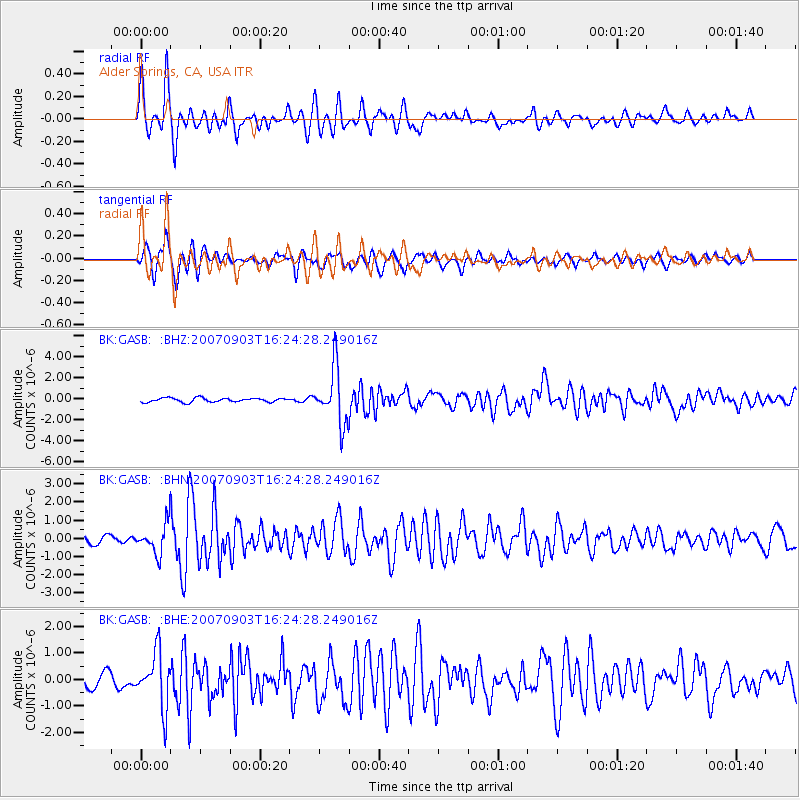
Signal To Noise
| Channel | StoN | STA | LTA |
| BK:GASB: :BHN:20070903T16:24:28.249016Z | 4.3782206 | 8.1872923E-7 | 1.8700045E-7 |
| BK:GASB: :BHE:20070903T16:24:28.249016Z | 3.8334327 | 1.0329207E-6 | 2.694506E-7 |
| BK:GASB: :BHZ:20070903T16:24:28.249016Z | 13.797166 | 2.6418447E-6 | 1.9147735E-7 |
| Arrivals |
| Ps | 4.4 SECOND |
| PpPs | 13 SECOND |
| PsPs/PpSs | 17 SECOND |


