You are here: Home > Network List > BK - Berkeley Digital Seismograph Network Stations List
> Station GASB Alder Springs, CA, USA > Earthquake Result Viewer
GASB Alder Springs, CA, USA - Earthquake Result Viewer
| Earthquake location: |
Vanuatu Islands |
| Earthquake latitude/longitude: |
-15.4/168.6 |
| Earthquake time(UTC): |
2007/07/15 (196) 09:27:34 GMT |
| Earthquake Depth: |
8.0 km |
| Earthquake Magnitude: |
6.0 MB, 5.8 MS, 6.1 MW, 6.0 MW |
| Earthquake Catalog/Contributor: |
WHDF/NEIC |
|
| Network: |
BK Berkeley Digital Seismograph Network |
| Station: |
GASB Alder Springs, CA, USA |
| Lat/Lon: |
39.65 N/122.72 W |
| Elevation: |
1355 m |
|
| Distance: |
84.1 deg |
| Az: |
46.308 deg |
| Baz: |
244.618 deg |
| Ray Param: |
0.045735147 |
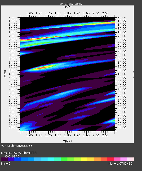
| Estimated Moho Depth: |
20.75 km |
| Estimated Crust Vp/Vs: |
1.70 |
| Assumed Crust Vp: |
6.472 km/s |
| Estimated Crust Vs: |
3.813 km/s |
| Estimated Crust Poisson's Ratio: |
0.23 |
|
| Radial Match: |
95.033966 % |
| Radial Bump: |
295 |
| Transverse Match: |
92.81078 % |
| Transverse Bump: |
385 |
| SOD ConfigId: |
2564 |
| Insert Time: |
2010-03-05 19:18:25.063 +0000 |
| GWidth: |
2.5 |
| Max Bumps: |
400 |
| Tol: |
0.001 |
|
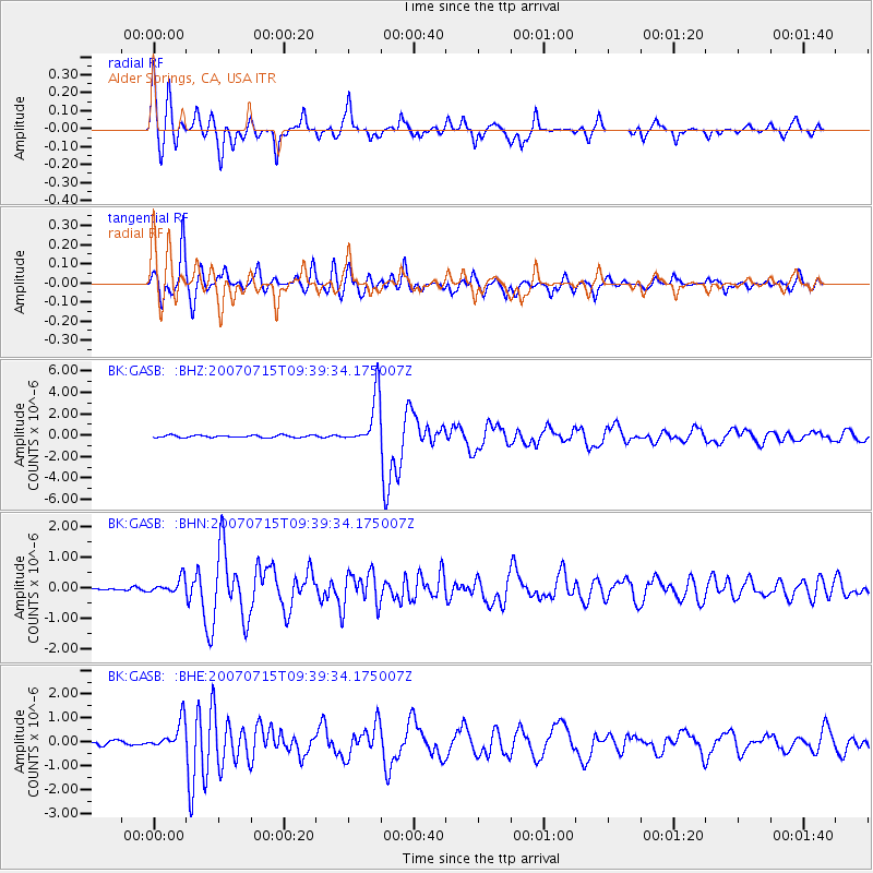
Signal To Noise
| Channel | StoN | STA | LTA |
| BK:GASB: :BHN:20070715T09:39:34.175007Z | 4.1214924 | 2.4200708E-7 | 5.8718307E-8 |
| BK:GASB: :BHE:20070715T09:39:34.175007Z | 4.2392445 | 5.973771E-7 | 1.4091594E-7 |
| BK:GASB: :BHZ:20070715T09:39:34.175007Z | 22.364462 | 2.341758E-6 | 1.0470889E-7 |
| Arrivals |
| Ps | 2.3 SECOND |
| PpPs | 8.4 SECOND |
| PsPs/PpSs | 11 SECOND |


