You are here: Home > Network List > BK - Berkeley Digital Seismograph Network Stations List
> Station GASB Alder Springs, CA, USA > Earthquake Result Viewer
GASB Alder Springs, CA, USA - Earthquake Result Viewer
| Earthquake location: |
Solomon Islands |
| Earthquake latitude/longitude: |
-8.0/154.6 |
| Earthquake time(UTC): |
2007/06/28 (179) 02:52:09 GMT |
| Earthquake Depth: |
10 km |
| Earthquake Magnitude: |
6.3 MB, 6.7 MS, 6.7 MW, 6.7 MW |
| Earthquake Catalog/Contributor: |
WHDF/NEIC |
|
| Network: |
BK Berkeley Digital Seismograph Network |
| Station: |
GASB Alder Springs, CA, USA |
| Lat/Lon: |
39.65 N/122.72 W |
| Elevation: |
1355 m |
|
| Distance: |
89.4 deg |
| Az: |
49.97 deg |
| Baz: |
259.232 deg |
| Ray Param: |
0.04186754 |
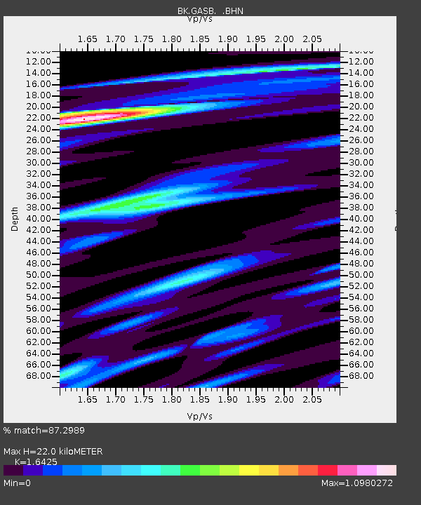
| Estimated Moho Depth: |
22.0 km |
| Estimated Crust Vp/Vs: |
1.64 |
| Assumed Crust Vp: |
6.472 km/s |
| Estimated Crust Vs: |
3.94 km/s |
| Estimated Crust Poisson's Ratio: |
0.21 |
|
| Radial Match: |
87.2989 % |
| Radial Bump: |
400 |
| Transverse Match: |
91.492134 % |
| Transverse Bump: |
400 |
| SOD ConfigId: |
2564 |
| Insert Time: |
2010-03-05 19:18:29.689 +0000 |
| GWidth: |
2.5 |
| Max Bumps: |
400 |
| Tol: |
0.001 |
|

Signal To Noise
| Channel | StoN | STA | LTA |
| BK:GASB: :BHN:20070628T03:04:34.949011Z | 0.9790359 | 1.0462502E-7 | 1.0686536E-7 |
| BK:GASB: :BHE:20070628T03:04:34.949011Z | 4.254376 | 4.309118E-7 | 1.0128673E-7 |
| BK:GASB: :BHZ:20070628T03:04:34.949011Z | 14.970211 | 1.5318278E-6 | 1.0232506E-7 |
| Arrivals |
| Ps | 2.2 SECOND |
| PpPs | 8.8 SECOND |
| PsPs/PpSs | 11 SECOND |


