You are here: Home > Network List > BK - Berkeley Digital Seismograph Network Stations List
> Station GASB Alder Springs, CA, USA > Earthquake Result Viewer
GASB Alder Springs, CA, USA - Earthquake Result Viewer
| Earthquake location: |
Solomon Islands |
| Earthquake latitude/longitude: |
-8.5/157.0 |
| Earthquake time(UTC): |
2007/04/01 (091) 20:39:56 GMT |
| Earthquake Depth: |
10 km |
| Earthquake Magnitude: |
6.8 MB, 7.9 MS, 8.1 MW, 7.7 ME |
| Earthquake Catalog/Contributor: |
WHDF/NEIC |
|
| Network: |
BK Berkeley Digital Seismograph Network |
| Station: |
GASB Alder Springs, CA, USA |
| Lat/Lon: |
39.65 N/122.72 W |
| Elevation: |
1355 m |
|
| Distance: |
87.9 deg |
| Az: |
49.583 deg |
| Baz: |
257.316 deg |
| Ray Param: |
0.04298326 |
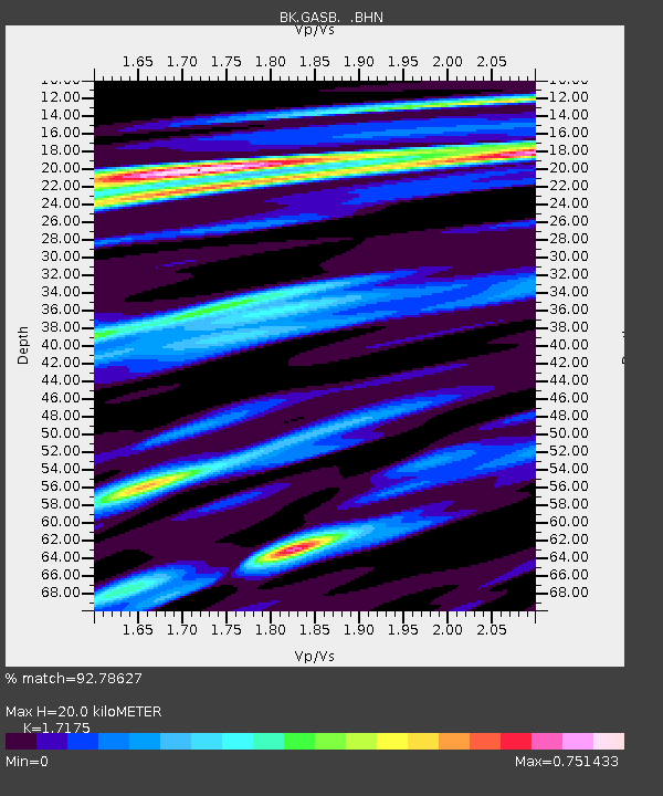
| Estimated Moho Depth: |
20.0 km |
| Estimated Crust Vp/Vs: |
1.72 |
| Assumed Crust Vp: |
6.472 km/s |
| Estimated Crust Vs: |
3.768 km/s |
| Estimated Crust Poisson's Ratio: |
0.24 |
|
| Radial Match: |
92.78627 % |
| Radial Bump: |
400 |
| Transverse Match: |
95.68322 % |
| Transverse Bump: |
335 |
| SOD ConfigId: |
2564 |
| Insert Time: |
2010-03-05 19:18:31.723 +0000 |
| GWidth: |
2.5 |
| Max Bumps: |
400 |
| Tol: |
0.001 |
|

Signal To Noise
| Channel | StoN | STA | LTA |
| BK:GASB: :BHN:20070401T20:52:14.575007Z | 1.3836489 | 3.8506522E-7 | 2.782969E-7 |
| BK:GASB: :BHE:20070401T20:52:14.575007Z | 1.6398399 | 4.217841E-7 | 2.5721056E-7 |
| BK:GASB: :BHZ:20070401T20:52:14.575007Z | 6.685741 | 2.0056948E-6 | 2.999959E-7 |
| Arrivals |
| Ps | 2.3 SECOND |
| PpPs | 8.2 SECOND |
| PsPs/PpSs | 10 SECOND |


