You are here: Home > Network List > BK - Berkeley Digital Seismograph Network Stations List
> Station GASB Alder Springs, CA, USA > Earthquake Result Viewer
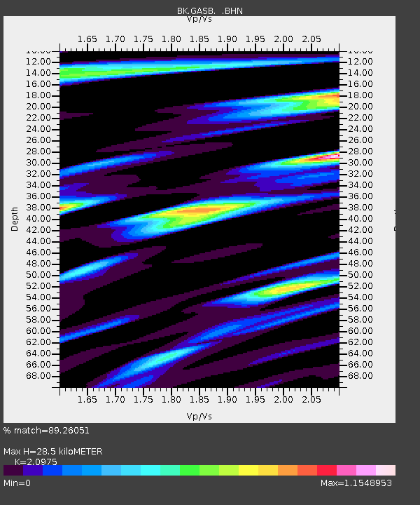
GASB Alder Springs, CA, USA - Earthquake Result Viewer
| Earthquake location: |
Near Coast Of Peru |
| Earthquake latitude/longitude: |
-13.5/-76.7 |
| Earthquake time(UTC): |
2006/10/20 (293) 10:48:56 GMT |
| Earthquake Depth: |
23 km |
| Earthquake Magnitude: |
5.9 MB, 6.6 MS, 6.7 MW, 6.6 MW |
| Earthquake Catalog/Contributor: |
WHDF/NEIC |
|
| Network: |
BK Berkeley Digital Seismograph Network |
| Station: |
GASB Alder Springs, CA, USA |
| Lat/Lon: |
39.65 N/122.72 W |
| Elevation: |
1355 m |
|
| Distance: |
68.0 deg |
| Az: |
323.181 deg |
| Baz: |
130.954 deg |
| Ray Param: |
0.05655417 |
| Estimated Moho Depth: |
28.5 km |
| Estimated Crust Vp/Vs: |
2.10 |
| Assumed Crust Vp: |
6.472 km/s |
| Estimated Crust Vs: |
3.086 km/s |
| Estimated Crust Poisson's Ratio: |
0.35 |
|
| Radial Match: |
89.26051 % |
| Radial Bump: |
400 |
| Transverse Match: |
87.49623 % |
| Transverse Bump: |
400 |
| SOD ConfigId: |
2665 |
| Insert Time: |
2010-03-05 19:18:40.485 +0000 |
| GWidth: |
2.5 |
| Max Bumps: |
400 |
| Tol: |
0.001 |
|

Signal To Noise
| Channel | StoN | STA | LTA |
| BK:GASB: :BHN:20061020T10:59:22.226003Z | 0.73358816 | 5.161733E-7 | 7.0362825E-7 |
| BK:GASB: :BHE:20061020T10:59:22.226003Z | 2.75423 | 6.530638E-7 | 2.3711303E-7 |
| BK:GASB: :BHZ:20061020T10:59:22.226003Z | 2.9463785 | 9.05741E-7 | 3.0740821E-7 |
| Arrivals |
| Ps | 5.0 SECOND |
| PpPs | 13 SECOND |
| PsPs/PpSs | 18 SECOND |


