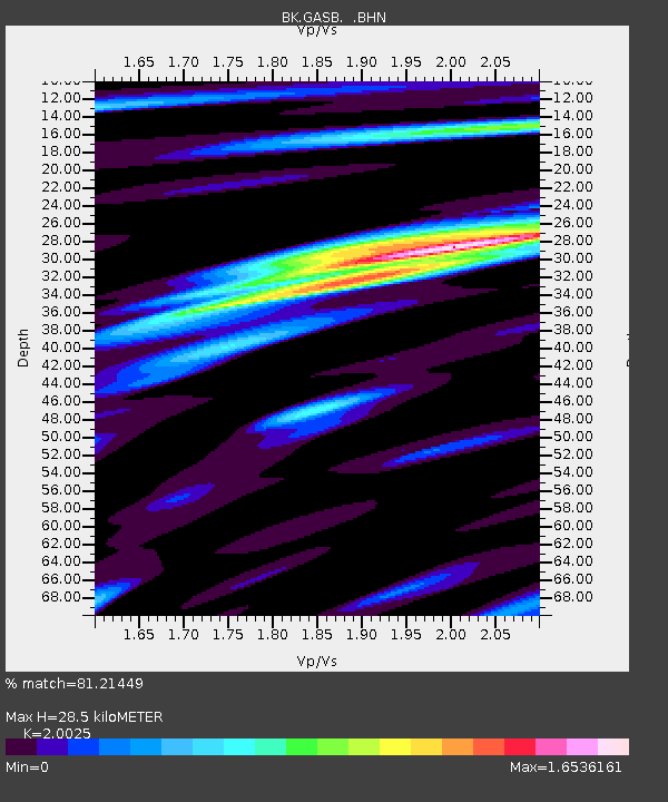
GASB Alder Springs, CA, USA - Earthquake Result Viewer

Earthquake location: Rat Islands, Aleutian Islands
Earthquake latitude/longitude: 51.8/177.1
Earthquake time(UTC): 2006/06/14 (165) 04:18:42 GMT
Earthquake Depth: 14 km
Earthquake Magnitude: 5.9 MB, 6.4 MS, 6.4 MW, 6.4 MW
Earthquake Catalog/Contributor: WHDF/NEIC
Network: BK Berkeley Digital Seismograph Network
Station: GASB Alder Springs, CA, USA
Lat/Lon: 39.65 N/122.72 W
Elevation: 1355 m
Distance: 42.6 deg
Az: 81.962 deg
Baz: 307.127 deg
Ray Param: 0.07308512
Estimated Moho Depth: 28.5 km
Estimated Crust Vp/Vs: 2.00
Assumed Crust Vp: 6.472 km/s
Estimated Crust Vs: 3.232 km/s
Estimated Crust Poisson's Ratio: 0.33
Radial Match: 81.21449 %
Radial Bump: 400
Transverse Match: 72.994316 %
Transverse Bump: 400
SOD ConfigId: 5745
Insert Time: 2010-03-05 19:19:01.990 +0000
GWidth: 2.5
Max Bumps: 400
Tol: 0.001

Signal To Noise

ChannelStoNSTALTA
BK:GASB: :BHN:20060614T04:26:06.999014Z1.32393834.4947018E-73.3949485E-7
BK:GASB: :BHE:20060614T04:26:06.999014Z1.32328774.5034528E-73.4032303E-7
BK:GASB: :BHZ:20060614T04:26:06.999014Z2.18281416.2087526E-72.84438E-7
Arrivals
Ps4.7 SECOND
PpPs12 SECOND
PsPs/PpSs17 SECOND