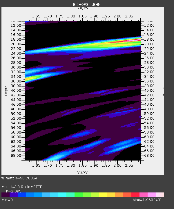
HOPS Hopland Field Station, Hopland, CA - Earthquake Result Viewer
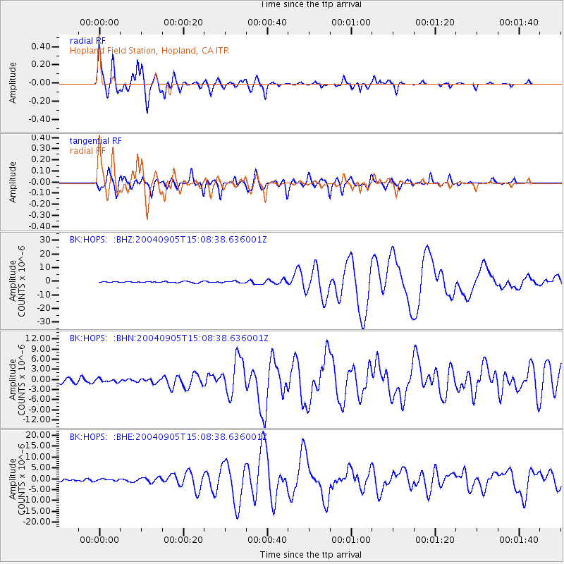
Earthquake location: Near S. Coast Of Honshu, Japan
Earthquake latitude/longitude: 33.2/137.1
Earthquake time(UTC): 2004/09/05 (249) 14:57:18 GMT
Earthquake Depth: 10 km
Earthquake Magnitude: 6.2 MB, 7.1 MS, 7.4 MW, 7.4 MW
Earthquake Catalog/Contributor: WHDF/NEIC
Network: BK Berkeley Digital Seismograph Network
Station: HOPS Hopland Field Station, Hopland, CA
Lat/Lon: 38.99 N/123.07 W
Elevation: 299 m
Distance: 76.7 deg
Az: 52.077 deg
Baz: 301.91 deg
Ray Param: 0.050797198
Estimated Moho Depth: 18.0 km
Estimated Crust Vp/Vs: 2.10
Assumed Crust Vp: 6.472 km/s
Estimated Crust Vs: 3.089 km/s
Estimated Crust Poisson's Ratio: 0.35
Radial Match: 96.78864 %
Radial Bump: 400
Transverse Match: 88.38746 %
Transverse Bump: 400
SOD ConfigId: 124340
Insert Time: 2010-03-05 19:19:11.889 +0000
GWidth: 2.5
Max Bumps: 400
Tol: 0.001

Signal To Noise

ChannelStoNSTALTA
BK:HOPS: :BHN:20040905T15:08:38.636001Z0.76398254.782448E-76.2598923E-7
BK:HOPS: :BHE:20040905T15:08:38.636001Z0.989810473.8447115E-73.8842907E-7
BK:HOPS: :BHZ:20040905T15:08:38.636001Z1.59836916.4327327E-74.02456E-7
Arrivals
Ps3.1 SECOND
PpPs8.4 SECOND
PsPs/PpSs12 SECOND