
Station BK HOPS - Hopland Field Station, Hopland, CA
Network: BK - Berkeley Digital Seismograph Network
Nearby stations (2 deg radius)
| Station | Name | (Lat, Lon) | Start / End | Elevation |
| HOPS | Hopland Field Station, Hopland, CA | (38.99, -123.07) | 1998-03-24 / 2499-01-01 | 299 m |
| Crust2 Type: | T6,Margin /shield transition, 1 km seds. |
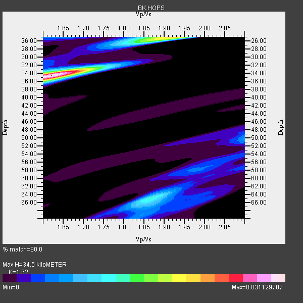
| Thickness Estimate: | 34 km |
| Thickness StdDev: | 5.2 km |
| Vp/Vs Estimate: | 1.62 |
| Vp/Vs StdDev: | 0.09 |
| Vs Estimate: | 3.995 km/s |
| Poisson's Ratio: | 0.19 |
| Peak Value: | 0.03 |
| Assumed Vp: | 6.472 km/s |
| Ps Weight: | 0.33333334 |
| PpPs Weight: | 0.33333334 |
| PsPs Weight: | 0.33333328 |
| Residual Complexity: | 0.632 |
| Nearby stations H: | +- |
| (2.0 deg) Vp/Vs: | +- |
19 with match > 90% ( 51.351353 %) and 35 with match > 80% ( 94.5946 %) out of 37.
Download stack as xyz text file.
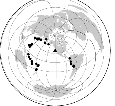
Azimuth Distribution of Events:
Prior Results for this Station
| Study | Thickness | Vp/Vs | Vp | Vs | Poissons Ratio | Extra |
| EARS | 34 km | 1.62 | 6.472 km/s | 3.995 km/s | 0.19 | |
| Crust2.0 | 32 km | 1.79 | 6.472 km/s | 3.622 km/s | 0.27 | T6,Margin /shield transition, 1 km seds. |
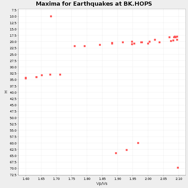
| Global Maxima | 34 km | 1.62 | 6.472 km/s | 3.995 km/s | 0.19 | amp=0.031129707 |
| Local Maxima 1 | 25 km | 1.92 | 6.472 km/s | 3.371 km/s | 0.31 | amp=0.02050196 |
| Local Maxima 2 | 65 km | 1.87 | 6.472 km/s | 3.461 km/s | 0.30 | amp=0.013127842 |
| Local Maxima 3 | 50 km | 2.10 | 6.472 km/s | 3.086 km/s | 0.35 | amp=0.006214912 |
| Local Maxima 4 | 66 km | 1.88 | 6.472 km/s | 3.442 km/s | 0.30 | amp=0.005590813 |
| Predicted Arrivals for vertical incidence (zero ray parameter) | |
| Ps | 3.31 SECOND |
| PpPs | 13.97 SECOND |
| PsPs/PpSs | 17.27 SECOND |
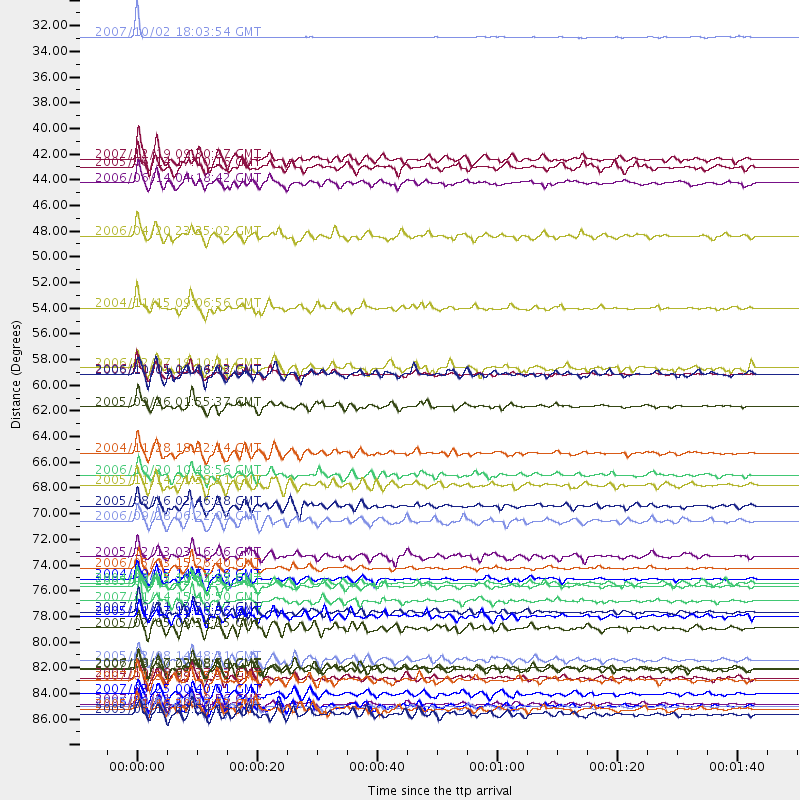
Events Processed for this Station
Download zip of receiver functions as SAC
Plot maxima for each earthquake.
Events Used in the Stack
(35 events)| Radial Match | Distance | Baz | FERegion | Time | Lat/Lon | Depth | Magnitude |
| 97.35293 | 59.1 deg | 307.007 deg | Kuril Islands | 2006/11/15 11:14:13 GMT | (46.6, 153.3) | 10 km | 6.5 MB, 7.8 MS, 8.3 MW, 7.9 MW |
| 96.78864 | 76.7 deg | 301.91 deg | Near S. Coast Of Honshu, Japan | 2004/09/05 14:57:18 GMT | (33.2, 137.1) | 10 km | 6.2 MB, 7.1 MS, 7.4 MW, 7.4 MW |
| 96.31713 | 78.7 deg | 130.848 deg | Northern Chile | 2007/11/14 15:40:50 GMT | (-22.2, -69.9) | 40 km | 6.7 MB, 7.4 MS, 7.7 MW, 7.4 ME |
| 96.094154 | 30.2 deg | 313.495 deg | Alaska Peninsula | 2007/10/02 18:03:54 GMT | (54.4, -161.7) | 47 km | 5.6 MB, 5.2 ML |
| 95.8053 | 87.5 deg | 257.115 deg | Solomon Islands | 2007/04/01 20:39:56 GMT | (-8.5, 157.0) | 10 km | 6.8 MB, 7.9 MS, 8.1 MW, 7.7 ME |
| 95.37697 | 77.3 deg | 128.867 deg | Northern Chile | 2005/06/13 22:44:33 GMT | (-20.0, -69.2) | 116 km | 6.8 MB, 7.8 MW, 7.8 MW |
| 94.99173 | 87.7 deg | 225.124 deg | Kermadec Islands Region | 2006/05/16 10:39:23 GMT | (-31.8, -179.3) | 152 km | 6.8 MB, 7.4 MW, 7.4 MW |
| 94.89866 | 75.8 deg | 228.895 deg | Tonga Islands | 2006/05/03 15:26:40 GMT | (-20.2, -174.1) | 55 km | 7.2 MB, 7.8 MS, 7.9 MW, 7.9 MW |
| 94.88064 | 77.1 deg | 302.059 deg | Near S. Coast Of Western Honshu | 2004/09/05 10:07:07 GMT | (33.1, 136.6) | 14 km | 6.7 MB, 7.0 MS, 7.2 MW, 7.0 MW |
| 94.22085 | 71.8 deg | 229.592 deg | Samoa Islands Region | 2006/09/28 06:22:09 GMT | (-16.6, -172.0) | 28 km | 6.5 MB, 6.6 MS, 6.9 MW, 6.7 MW |
| 93.22064 | 68.7 deg | 302.199 deg | Off East Coast Of Honshu, Japan | 2005/11/14 21:38:51 GMT | (38.1, 144.9) | 11 km | 6.7 MB, 6.8 MS, 7.0 MW, 6.9 MW |
| 93.003296 | 87.7 deg | 262.381 deg | New Ireland Region, P.N.G. | 2005/09/09 07:26:43 GMT | (-4.5, 153.5) | 90 km | 6.3 MB, 7.7 MW, 7.5 MW |
| 92.77813 | 79.9 deg | 129.449 deg | Chile-Bolivia Border Region | 2005/11/17 19:26:56 GMT | (-22.3, -67.9) | 163 km | 6.0 MB, 6.9 MW, 6.8 MW |
| 92.70459 | 61.9 deg | 124.872 deg | Northern Peru | 2005/09/26 01:55:37 GMT | (-5.7, -76.4) | 115 km | 6.7 MB, 7.5 MW, 7.5 MW |
| 91.09763 | 88.3 deg | 224.626 deg | South Of Kermadec Islands | 2005/05/16 03:54:14 GMT | (-32.6, -179.4) | 34 km | 6.2 MB, 6.4 MS, 6.6 MW, 6.6 MW |
| 90.96971 | 53.5 deg | 117.718 deg | Near West Coast Of Colombia | 2004/11/15 09:06:56 GMT | (4.7, -77.5) | 15 km | 6.6 MB, 7.1 MS, 7.2 MW, 7.1 MW |
| 90.61284 | 65.9 deg | 306.58 deg | Hokkaido, Japan Region | 2004/11/28 18:32:14 GMT | (43.0, 145.1) | 39 km | 6.4 MB, 6.7 MS, 7.0 MW, 7.0 MW |
| 90.152115 | 47.3 deg | 321.438 deg | Eastern Siberia, Russia | 2006/04/20 23:25:02 GMT | (60.9, 167.1) | 22 km | 6.8 MB, 7.6 MS, 7.6 MW, 7.3 MW |
| 90.08825 | 74.8 deg | 235.508 deg | Fiji Islands Region | 2005/12/13 03:16:06 GMT | (-15.3, -178.6) | 10 km | 6.1 MB, 6.8 MS, 6.7 MW, 6.7 MW |
| 89.489876 | 59.2 deg | 306.888 deg | Kuril Islands | 2006/10/01 09:06:02 GMT | (46.5, 153.2) | 19 km | 6.1 MB, 6.4 MS, 6.6 MW, 6.5 MW |
| 89.37813 | 70.5 deg | 303.688 deg | Near East Coast Of Honshu, Japan | 2005/08/16 02:46:28 GMT | (38.3, 142.0) | 36 km | 6.5 MB, 6.8 MS, 7.2 MW, 7.1 MW |
| 88.98346 | 84.4 deg | 278.871 deg | South Of Mariana Islands | 2007/09/30 02:08:30 GMT | (10.5, 145.7) | 14 km | 6.4 MB, 7.1 MS, 6.9 MW, 6.9 MW |
| 88.2915 | 84.4 deg | 244.686 deg | Vanuatu Islands | 2006/08/07 22:18:54 GMT | (-15.8, 167.8) | 141 km | 6.0 MB, 6.8 MW, 6.8 MW |
| 88.091125 | 86.6 deg | 240.156 deg | Vanuatu Islands | 2007/03/25 00:40:01 GMT | (-20.6, 169.4) | 34 km | 6.5 MB, 7.0 MS, 7.1 MW, 7.1 MW |
| 87.50152 | 85.4 deg | 225.547 deg | Kermadec Islands, New Zealand | 2007/01/31 03:15:52 GMT | (-29.8, -178.0) | 34 km | 6.1 MB, 6.3 MS, 6.5 MW, 6.4 MW |
| 86.970184 | 42.8 deg | 307.653 deg | Rat Islands, Aleutian Islands | 2006/06/14 04:18:42 GMT | (51.8, 177.1) | 14 km | 5.9 MB, 6.4 MS, 6.4 MW, 6.4 MW |
| 86.27069 | 80.9 deg | 283.157 deg | Mariana Islands | 2005/02/05 03:34:25 GMT | (16.0, 145.9) | 143 km | 6.3 MB, 6.6 MW, 6.5 MW |
| 86.26782 | 79.5 deg | 285.758 deg | Mariana Islands | 2007/10/31 03:30:17 GMT | (18.9, 145.4) | 223 km | 6.2 MB, 7.2 MW, 7.2 MW |
| 86.10098 | 41.4 deg | 306.636 deg | Rat Islands, Aleutian Islands | 2005/06/14 17:10:16 GMT | (51.2, 179.4) | 51 km | 6.0 MB, 6.8 MW, 6.6 MW |
| 85.78303 | 83.7 deg | 246.16 deg | Vanuatu Islands | 2005/02/08 14:48:21 GMT | (-14.3, 167.3) | 206 km | 6.1 MB, 6.8 MW, 6.7 MW |
| 84.07167 | 87.9 deg | 282.254 deg | W. Caroline Islands, Micronesia | 2005/01/16 20:17:52 GMT | (10.9, 140.8) | 25 km | 6.3 MB, 6.7 MS, 6.6 MW, 6.6 MW |
| 82.19744 | 67.8 deg | 130.453 deg | Near Coast Of Peru | 2006/10/20 10:48:56 GMT | (-13.5, -76.7) | 23 km | 5.9 MB, 6.6 MS, 6.7 MW, 6.6 MW |
| 82.16344 | 85.3 deg | 251.95 deg | Solomon Islands | 2004/10/08 08:27:53 GMT | (-11.0, 162.2) | 36 km | 6.1 MB, 6.9 MS, 6.8 MW, 6.8 MW |
| 82.0282 | 40.7 deg | 306.736 deg | Andreanof Islands, Aleutian Is. | 2007/12/19 09:30:27 GMT | (51.4, -179.5) | 29 km | 6.4 MB, 7.1 MS, 7.1 MW, 7.0 MW |
| 80.534065 | 58.6 deg | 306.155 deg | East Of Kuril Islands | 2006/12/07 19:10:21 GMT | (46.2, 154.4) | 16 km | 6.3 MB, 6.1 MS, 6.3 MW, 6.3 MW |
Losers
(2 events)| Radial Match | Distance | Baz | FERegion | Time | Lat/Lon | Depth | Magnitude | Reason |
| 95.017685 | 76.6 deg | 233.929 deg | Fiji Islands Region | 2004/07/15 04:27:12 GMT | (-17.6, -178.6) | 560 km | 5.5 MB | |
| 66.41356 | 42.9 deg | 120.042 deg | Near Coast Of Nicaragua | 2005/07/02 02:16:43 GMT | (11.2, -86.2) | 27 km | 5.6 MB, 6.4 MS, 6.6 MW, 6.6 MW |
