You are here: Home > Network List > BK - Berkeley Digital Seismograph Network Stations List
> Station HOPS Hopland Field Station, Hopland, CA > Earthquake Result Viewer
HOPS Hopland Field Station, Hopland, CA - Earthquake Result Viewer
| Earthquake location: |
Vanuatu Islands |
| Earthquake latitude/longitude: |
-14.3/167.3 |
| Earthquake time(UTC): |
2005/02/08 (039) 14:48:21 GMT |
| Earthquake Depth: |
206 km |
| Earthquake Magnitude: |
6.1 MB, 6.8 MW, 6.7 MW |
| Earthquake Catalog/Contributor: |
WHDF/NEIC |
|
| Network: |
BK Berkeley Digital Seismograph Network |
| Station: |
HOPS Hopland Field Station, Hopland, CA |
| Lat/Lon: |
38.99 N/123.07 W |
| Elevation: |
299 m |
|
| Distance: |
83.7 deg |
| Az: |
47.318 deg |
| Baz: |
246.16 deg |
| Ray Param: |
0.045486324 |
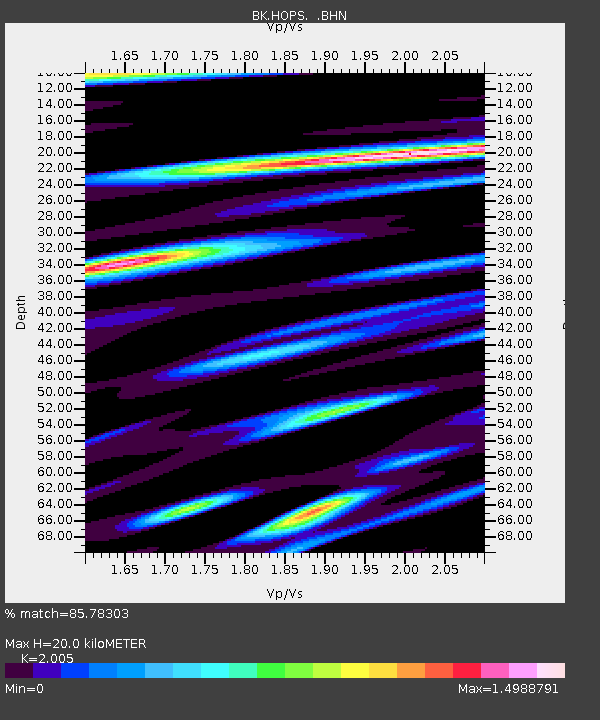
| Estimated Moho Depth: |
20.0 km |
| Estimated Crust Vp/Vs: |
2.01 |
| Assumed Crust Vp: |
6.472 km/s |
| Estimated Crust Vs: |
3.228 km/s |
| Estimated Crust Poisson's Ratio: |
0.33 |
|
| Radial Match: |
85.78303 % |
| Radial Bump: |
400 |
| Transverse Match: |
80.57253 % |
| Transverse Bump: |
400 |
| SOD ConfigId: |
5233 |
| Insert Time: |
2010-03-05 19:19:23.778 +0000 |
| GWidth: |
2.5 |
| Max Bumps: |
400 |
| Tol: |
0.001 |
|
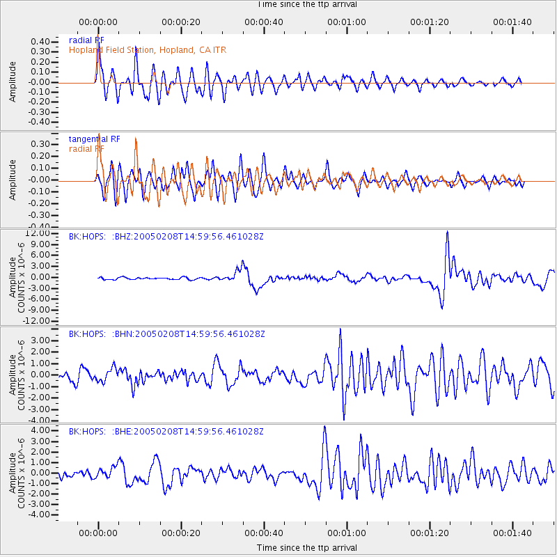
Signal To Noise
| Channel | StoN | STA | LTA |
| BK:HOPS: :BHN:20050208T14:59:56.461028Z | 1.2384466 | 5.781569E-7 | 4.6684045E-7 |
| BK:HOPS: :BHE:20050208T14:59:56.461028Z | 1.9693373 | 5.542865E-7 | 2.8145837E-7 |
| BK:HOPS: :BHZ:20050208T14:59:56.461028Z | 5.8520513 | 1.669491E-6 | 2.8528305E-7 |
| Arrivals |
| Ps | 3.2 SECOND |
| PpPs | 9.1 SECOND |
| PsPs/PpSs | 12 SECOND |


