You are here: Home > Network List > BK - Berkeley Digital Seismograph Network Stations List
> Station HOPS Hopland Field Station, Hopland, CA > Earthquake Result Viewer
HOPS Hopland Field Station, Hopland, CA - Earthquake Result Viewer
| Earthquake location: |
Fiji Islands Region |
| Earthquake latitude/longitude: |
-15.3/-178.6 |
| Earthquake time(UTC): |
2005/12/13 (347) 03:16:06 GMT |
| Earthquake Depth: |
10 km |
| Earthquake Magnitude: |
6.1 MB, 6.8 MS, 6.7 MW, 6.7 MW |
| Earthquake Catalog/Contributor: |
WHDF/NEIC |
|
| Network: |
BK Berkeley Digital Seismograph Network |
| Station: |
HOPS Hopland Field Station, Hopland, CA |
| Lat/Lon: |
38.99 N/123.07 W |
| Elevation: |
299 m |
|
| Distance: |
74.8 deg |
| Az: |
41.718 deg |
| Baz: |
235.508 deg |
| Ray Param: |
0.05208504 |
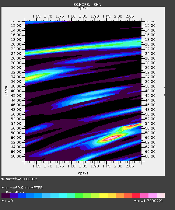
| Estimated Moho Depth: |
60.0 km |
| Estimated Crust Vp/Vs: |
1.97 |
| Assumed Crust Vp: |
6.472 km/s |
| Estimated Crust Vs: |
3.289 km/s |
| Estimated Crust Poisson's Ratio: |
0.33 |
|
| Radial Match: |
90.08825 % |
| Radial Bump: |
400 |
| Transverse Match: |
79.40744 % |
| Transverse Bump: |
400 |
| SOD ConfigId: |
2422 |
| Insert Time: |
2010-03-05 19:19:27.220 +0000 |
| GWidth: |
2.5 |
| Max Bumps: |
400 |
| Tol: |
0.001 |
|
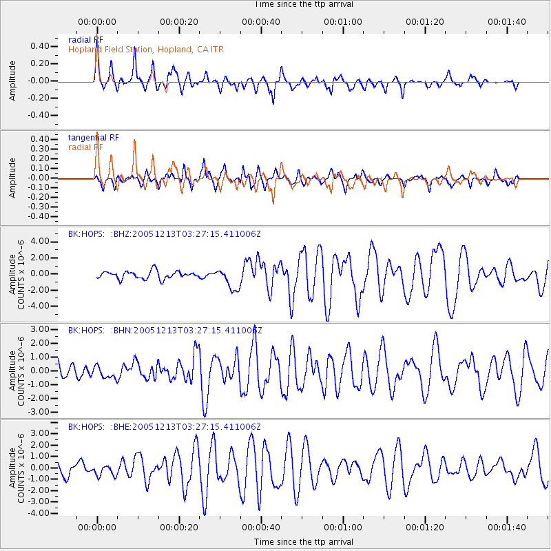
Signal To Noise
| Channel | StoN | STA | LTA |
| BK:HOPS: :BHN:20051213T03:27:15.411006Z | 0.806464 | 4.4126332E-7 | 5.471581E-7 |
| BK:HOPS: :BHE:20051213T03:27:15.411006Z | 0.9148572 | 4.797152E-7 | 5.243607E-7 |
| BK:HOPS: :BHZ:20051213T03:27:15.411006Z | 2.9073763 | 1.3626523E-6 | 4.6868797E-7 |
| Arrivals |
| Ps | 9.2 SECOND |
| PpPs | 27 SECOND |
| PsPs/PpSs | 36 SECOND |


