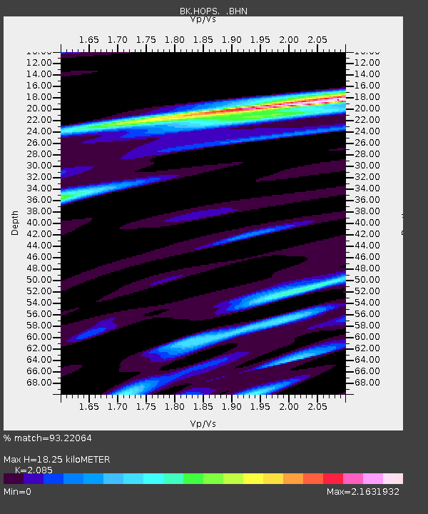
HOPS Hopland Field Station, Hopland, CA - Earthquake Result Viewer
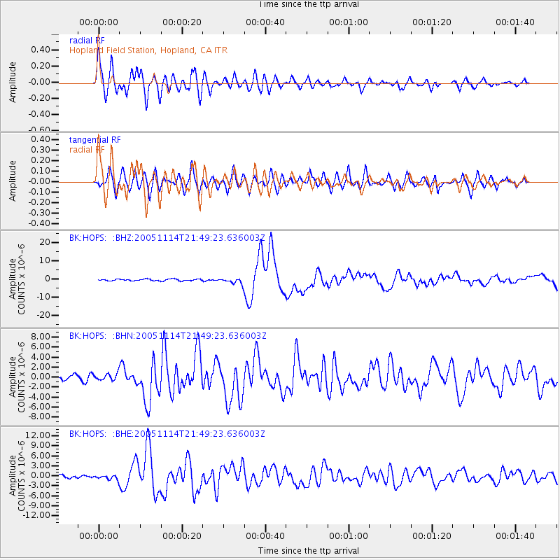
Earthquake location: Off East Coast Of Honshu, Japan
Earthquake latitude/longitude: 38.1/144.9
Earthquake time(UTC): 2005/11/14 (318) 21:38:51 GMT
Earthquake Depth: 11 km
Earthquake Magnitude: 6.7 MB, 6.8 MS, 7.0 MW, 6.9 MW
Earthquake Catalog/Contributor: WHDF/NEIC
Network: BK Berkeley Digital Seismograph Network
Station: HOPS Hopland Field Station, Hopland, CA
Lat/Lon: 38.99 N/123.07 W
Elevation: 299 m
Distance: 68.7 deg
Az: 56.712 deg
Baz: 302.199 deg
Ray Param: 0.05613395
Estimated Moho Depth: 18.25 km
Estimated Crust Vp/Vs: 2.09
Assumed Crust Vp: 6.472 km/s
Estimated Crust Vs: 3.104 km/s
Estimated Crust Poisson's Ratio: 0.35
Radial Match: 93.22064 %
Radial Bump: 400
Transverse Match: 79.36961 %
Transverse Bump: 400
SOD ConfigId: 2448
Insert Time: 2010-03-05 19:19:32.633 +0000
GWidth: 2.5
Max Bumps: 400
Tol: 0.001

Signal To Noise

ChannelStoNSTALTA
BK:HOPS: :BHN:20051114T21:49:23.636003Z1.25161456.627894E-75.2954755E-7
BK:HOPS: :BHE:20051114T21:49:23.636003Z1.0846146.8230963E-76.290806E-7
BK:HOPS: :BHZ:20051114T21:49:23.636003Z3.73205471.752376E-64.6954725E-7
Arrivals
Ps3.2 SECOND
PpPs8.4 SECOND
PsPs/PpSs12 SECOND