You are here: Home > Network List > BK - Berkeley Digital Seismograph Network Stations List
> Station HOPS Hopland Field Station, Hopland, CA > Earthquake Result Viewer
HOPS Hopland Field Station, Hopland, CA - Earthquake Result Viewer
| Earthquake location: |
Northern Chile |
| Earthquake latitude/longitude: |
-20.0/-69.2 |
| Earthquake time(UTC): |
2005/06/13 (164) 22:44:33 GMT |
| Earthquake Depth: |
116 km |
| Earthquake Magnitude: |
6.8 MB, 7.8 MW, 7.8 MW |
| Earthquake Catalog/Contributor: |
WHDF/NEIC |
|
| Network: |
BK Berkeley Digital Seismograph Network |
| Station: |
HOPS Hopland Field Station, Hopland, CA |
| Lat/Lon: |
38.99 N/123.07 W |
| Elevation: |
299 m |
|
| Distance: |
77.3 deg |
| Az: |
319.824 deg |
| Baz: |
128.867 deg |
| Ray Param: |
0.050114904 |
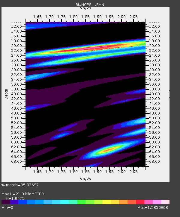
| Estimated Moho Depth: |
21.0 km |
| Estimated Crust Vp/Vs: |
1.95 |
| Assumed Crust Vp: |
6.472 km/s |
| Estimated Crust Vs: |
3.323 km/s |
| Estimated Crust Poisson's Ratio: |
0.32 |
|
| Radial Match: |
95.37697 % |
| Radial Bump: |
400 |
| Transverse Match: |
92.45456 % |
| Transverse Bump: |
400 |
| SOD ConfigId: |
124340 |
| Insert Time: |
2010-03-05 19:19:37.352 +0000 |
| GWidth: |
2.5 |
| Max Bumps: |
400 |
| Tol: |
0.001 |
|
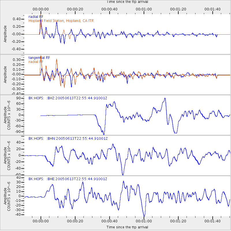
Signal To Noise
| Channel | StoN | STA | LTA |
| BK:HOPS: :BHN:20050613T22:55:44.91001Z | 13.024608 | 8.268638E-6 | 6.348474E-7 |
| BK:HOPS: :BHE:20050613T22:55:44.91001Z | 9.667802 | 6.708857E-6 | 6.939382E-7 |
| BK:HOPS: :BHZ:20050613T22:55:44.91001Z | 25.464897 | 3.1237294E-5 | 1.2266804E-6 |
| Arrivals |
| Ps | 3.2 SECOND |
| PpPs | 9.3 SECOND |
| PsPs/PpSs | 12 SECOND |


