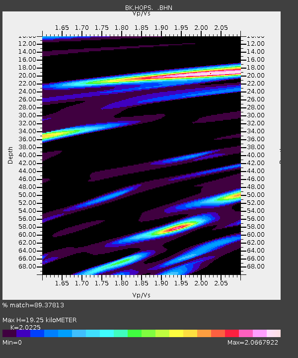
HOPS Hopland Field Station, Hopland, CA - Earthquake Result Viewer
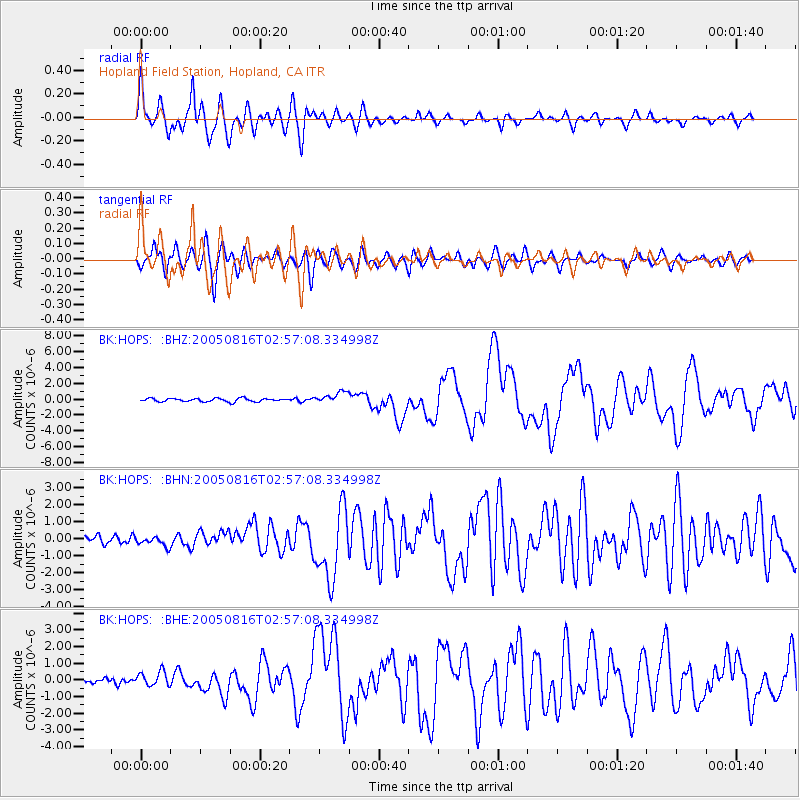
Earthquake location: Near East Coast Of Honshu, Japan
Earthquake latitude/longitude: 38.3/142.0
Earthquake time(UTC): 2005/08/16 (228) 02:46:28 GMT
Earthquake Depth: 36 km
Earthquake Magnitude: 6.5 MB, 6.8 MS, 7.2 MW, 7.1 MW
Earthquake Catalog/Contributor: WHDF/NEIC
Network: BK Berkeley Digital Seismograph Network
Station: HOPS Hopland Field Station, Hopland, CA
Lat/Lon: 38.99 N/123.07 W
Elevation: 299 m
Distance: 70.5 deg
Az: 55.472 deg
Baz: 303.688 deg
Ray Param: 0.054904956
Estimated Moho Depth: 19.25 km
Estimated Crust Vp/Vs: 2.02
Assumed Crust Vp: 6.472 km/s
Estimated Crust Vs: 3.2 km/s
Estimated Crust Poisson's Ratio: 0.34
Radial Match: 89.37813 %
Radial Bump: 400
Transverse Match: 77.52242 %
Transverse Bump: 400
SOD ConfigId: 2475
Insert Time: 2010-03-05 19:19:39.552 +0000
GWidth: 2.5
Max Bumps: 400
Tol: 0.001

Signal To Noise

ChannelStoNSTALTA
BK:HOPS: :BHN:20050816T02:57:08.334998Z0.67587792.8452172E-74.209661E-7
BK:HOPS: :BHE:20050816T02:57:08.334998Z1.0462274.397165E-74.2028785E-7
BK:HOPS: :BHZ:20050816T02:57:08.334998Z3.3684887.08139E-72.1022458E-7
Arrivals
Ps3.1 SECOND
PpPs8.7 SECOND
PsPs/PpSs12 SECOND