You are here: Home > Network List > BK - Berkeley Digital Seismograph Network Stations List
> Station HOPS Hopland Field Station, Hopland, CA > Earthquake Result Viewer
HOPS Hopland Field Station, Hopland, CA - Earthquake Result Viewer
| Earthquake location: |
New Ireland Region, P.N.G. |
| Earthquake latitude/longitude: |
-4.5/153.5 |
| Earthquake time(UTC): |
2005/09/09 (252) 07:26:43 GMT |
| Earthquake Depth: |
90 km |
| Earthquake Magnitude: |
6.3 MB, 7.7 MW, 7.5 MW |
| Earthquake Catalog/Contributor: |
WHDF/NEIC |
|
| Network: |
BK Berkeley Digital Seismograph Network |
| Station: |
HOPS Hopland Field Station, Hopland, CA |
| Lat/Lon: |
38.99 N/123.07 W |
| Elevation: |
299 m |
|
| Distance: |
87.7 deg |
| Az: |
50.787 deg |
| Baz: |
262.381 deg |
| Ray Param: |
0.04291516 |
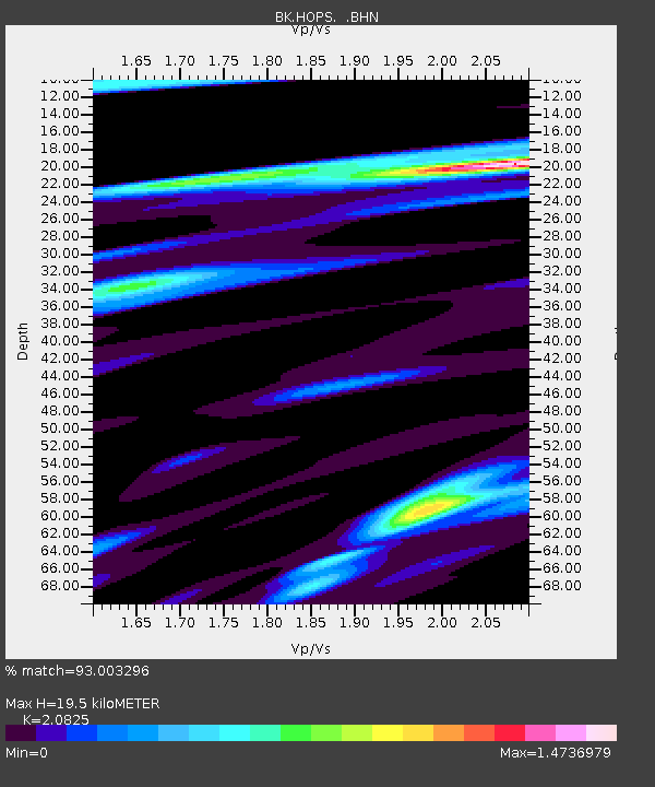
| Estimated Moho Depth: |
19.5 km |
| Estimated Crust Vp/Vs: |
2.08 |
| Assumed Crust Vp: |
6.472 km/s |
| Estimated Crust Vs: |
3.108 km/s |
| Estimated Crust Poisson's Ratio: |
0.35 |
|
| Radial Match: |
93.003296 % |
| Radial Bump: |
400 |
| Transverse Match: |
75.14819 % |
| Transverse Bump: |
400 |
| SOD ConfigId: |
2475 |
| Insert Time: |
2010-03-05 19:19:41.399 +0000 |
| GWidth: |
2.5 |
| Max Bumps: |
400 |
| Tol: |
0.001 |
|
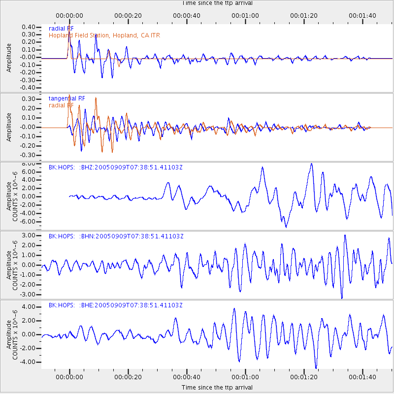
Signal To Noise
| Channel | StoN | STA | LTA |
| BK:HOPS: :BHN:20050909T07:38:51.41103Z | 0.75838447 | 3.3936843E-7 | 4.4748865E-7 |
| BK:HOPS: :BHE:20050909T07:38:51.41103Z | 2.5204291 | 6.5431044E-7 | 2.5960279E-7 |
| BK:HOPS: :BHZ:20050909T07:38:51.41103Z | 5.785341 | 1.7643927E-6 | 3.0497642E-7 |
| Arrivals |
| Ps | 3.3 SECOND |
| PpPs | 9.1 SECOND |
| PsPs/PpSs | 12 SECOND |


