You are here: Home > Network List > BK - Berkeley Digital Seismograph Network Stations List
> Station HOPS Hopland Field Station, Hopland, CA > Earthquake Result Viewer
HOPS Hopland Field Station, Hopland, CA - Earthquake Result Viewer
| Earthquake location: |
Northern Peru |
| Earthquake latitude/longitude: |
-5.7/-76.4 |
| Earthquake time(UTC): |
2005/09/26 (269) 01:55:37 GMT |
| Earthquake Depth: |
115 km |
| Earthquake Magnitude: |
6.7 MB, 7.5 MW, 7.5 MW |
| Earthquake Catalog/Contributor: |
WHDF/NEIC |
|
| Network: |
BK Berkeley Digital Seismograph Network |
| Station: |
HOPS Hopland Field Station, Hopland, CA |
| Lat/Lon: |
38.99 N/123.07 W |
| Elevation: |
299 m |
|
| Distance: |
61.9 deg |
| Az: |
320.025 deg |
| Baz: |
124.872 deg |
| Ray Param: |
0.060229305 |
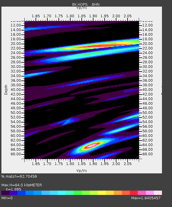
| Estimated Moho Depth: |
64.0 km |
| Estimated Crust Vp/Vs: |
1.89 |
| Assumed Crust Vp: |
6.472 km/s |
| Estimated Crust Vs: |
3.415 km/s |
| Estimated Crust Poisson's Ratio: |
0.31 |
|
| Radial Match: |
92.70459 % |
| Radial Bump: |
400 |
| Transverse Match: |
84.36662 % |
| Transverse Bump: |
400 |
| SOD ConfigId: |
2475 |
| Insert Time: |
2010-03-05 19:19:43.111 +0000 |
| GWidth: |
2.5 |
| Max Bumps: |
400 |
| Tol: |
0.001 |
|
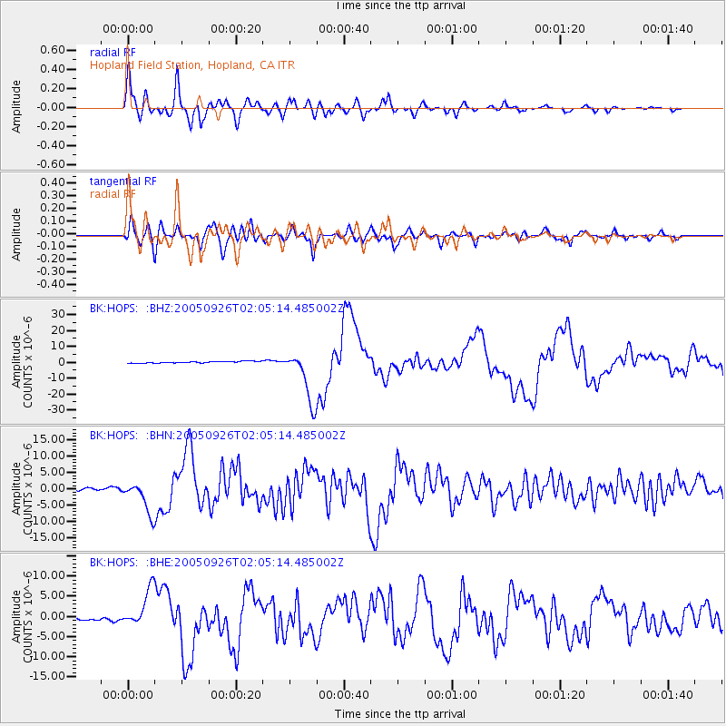
Signal To Noise
| Channel | StoN | STA | LTA |
| BK:HOPS: :BHN:20050926T02:05:14.485002Z | 10.033769 | 4.8814113E-6 | 4.8649827E-7 |
| BK:HOPS: :BHE:20050926T02:05:14.485002Z | 13.120809 | 4.7890876E-6 | 3.6499944E-7 |
| BK:HOPS: :BHZ:20050926T02:05:14.485002Z | 32.90758 | 1.6723423E-5 | 5.081936E-7 |
| Arrivals |
| Ps | 9.2 SECOND |
| PpPs | 27 SECOND |
| PsPs/PpSs | 37 SECOND |


