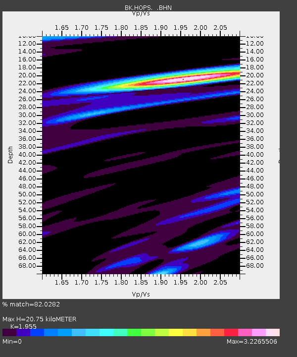
HOPS Hopland Field Station, Hopland, CA - Earthquake Result Viewer
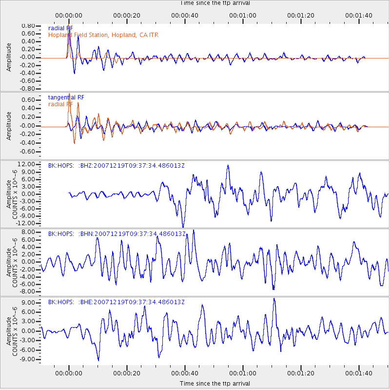
Earthquake location: Andreanof Islands, Aleutian Is.
Earthquake latitude/longitude: 51.4/-179.5
Earthquake time(UTC): 2007/12/19 (353) 09:30:27 GMT
Earthquake Depth: 29 km
Earthquake Magnitude: 6.4 MB, 7.1 MS, 7.1 MW, 7.0 MW
Earthquake Catalog/Contributor: WHDF/NEIC
Network: BK Berkeley Digital Seismograph Network
Station: HOPS Hopland Field Station, Hopland, CA
Lat/Lon: 38.99 N/123.07 W
Elevation: 299 m
Distance: 40.7 deg
Az: 84.953 deg
Baz: 306.736 deg
Ray Param: 0.07419851
Estimated Moho Depth: 20.75 km
Estimated Crust Vp/Vs: 1.96
Assumed Crust Vp: 6.472 km/s
Estimated Crust Vs: 3.31 km/s
Estimated Crust Poisson's Ratio: 0.32
Radial Match: 82.0282 %
Radial Bump: 400
Transverse Match: 69.17342 %
Transverse Bump: 400
SOD ConfigId: 2564
Insert Time: 2010-03-05 19:19:44.923 +0000
GWidth: 2.5
Max Bumps: 400
Tol: 0.001

Signal To Noise

ChannelStoNSTALTA
BK:HOPS: :BHN:20071219T09:37:34.486013Z1.33674091.4599483E-61.09217E-6
BK:HOPS: :BHE:20071219T09:37:34.486013Z1.12428431.5369596E-61.3670561E-6
BK:HOPS: :BHZ:20071219T09:37:34.486013Z3.58037542.8556424E-67.9758183E-7
Arrivals
Ps3.3 SECOND
PpPs8.9 SECOND
PsPs/PpSs12 SECOND