You are here: Home > Network List > BK - Berkeley Digital Seismograph Network Stations List
> Station HOPS Hopland Field Station, Hopland, CA > Earthquake Result Viewer
HOPS Hopland Field Station, Hopland, CA - Earthquake Result Viewer
| Earthquake location: |
Alaska Peninsula |
| Earthquake latitude/longitude: |
54.4/-161.7 |
| Earthquake time(UTC): |
2007/10/02 (275) 18:03:54 GMT |
| Earthquake Depth: |
47 km |
| Earthquake Magnitude: |
5.6 MB, 5.2 ML |
| Earthquake Catalog/Contributor: |
WHDF/NEIC |
|
| Network: |
BK Berkeley Digital Seismograph Network |
| Station: |
HOPS Hopland Field Station, Hopland, CA |
| Lat/Lon: |
38.99 N/123.07 W |
| Elevation: |
299 m |
|
| Distance: |
30.2 deg |
| Az: |
104.706 deg |
| Baz: |
313.495 deg |
| Ray Param: |
0.07933694 |
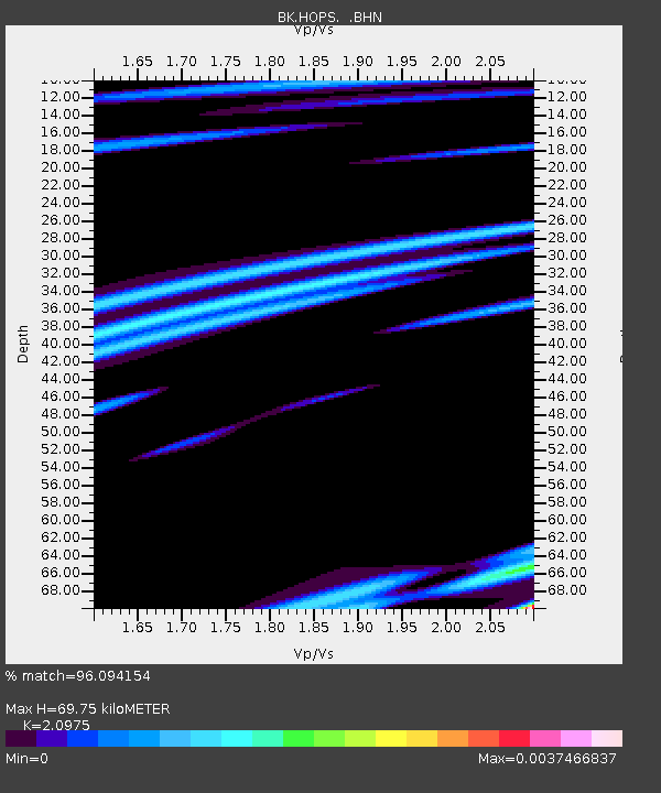
| Estimated Moho Depth: |
69.75 km |
| Estimated Crust Vp/Vs: |
2.10 |
| Assumed Crust Vp: |
6.472 km/s |
| Estimated Crust Vs: |
3.086 km/s |
| Estimated Crust Poisson's Ratio: |
0.35 |
|
| Radial Match: |
96.094154 % |
| Radial Bump: |
75 |
| Transverse Match: |
97.81955 % |
| Transverse Bump: |
60 |
| SOD ConfigId: |
2564 |
| Insert Time: |
2010-03-05 19:19:53.014 +0000 |
| GWidth: |
2.5 |
| Max Bumps: |
400 |
| Tol: |
0.001 |
|
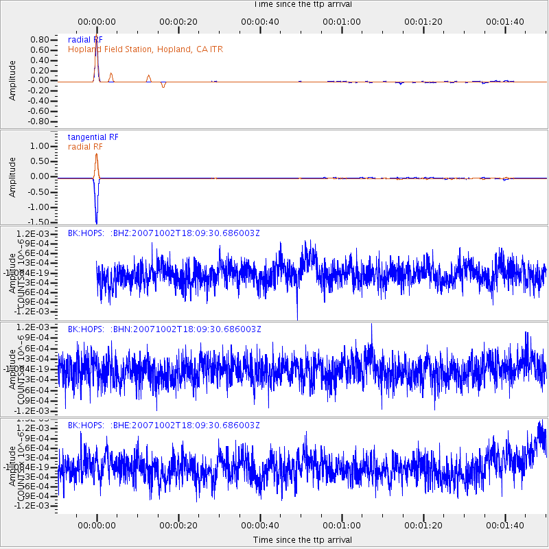
Signal To Noise
| Channel | StoN | STA | LTA |
| BK:HOPS: :BHN:20071002T18:09:30.686003Z | 1.1536871 | 3.493542E-10 | 3.0281538E-10 |
| BK:HOPS: :BHE:20071002T18:09:30.686003Z | 1.1845539 | 3.9162926E-10 | 3.306133E-10 |
| BK:HOPS: :BHZ:20071002T18:09:30.686003Z | 1.0442754 | 3.1884356E-10 | 3.0532515E-10 |
| Arrivals |
| Ps | 13 SECOND |
| PpPs | 31 SECOND |
| PsPs/PpSs | 44 SECOND |


