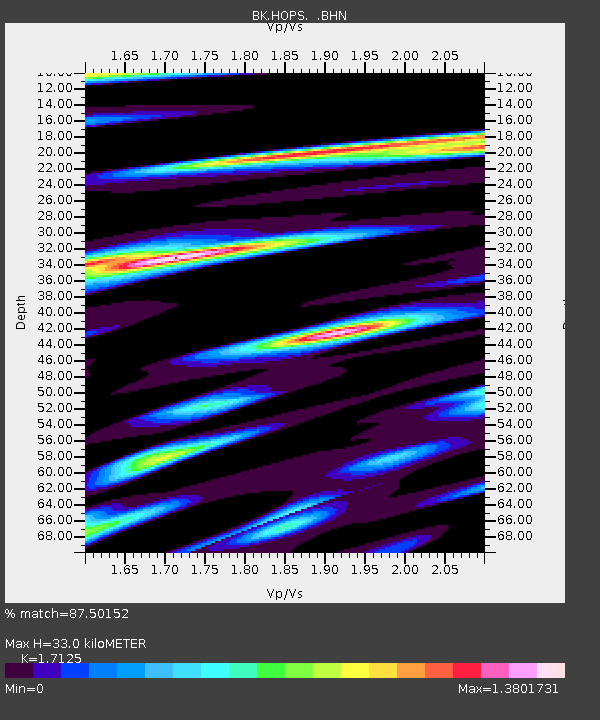
HOPS Hopland Field Station, Hopland, CA - Earthquake Result Viewer
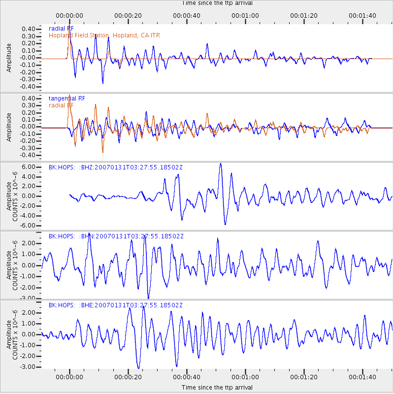
Earthquake location: Kermadec Islands, New Zealand
Earthquake latitude/longitude: -29.8/-178.0
Earthquake time(UTC): 2007/01/31 (031) 03:15:52 GMT
Earthquake Depth: 34 km
Earthquake Magnitude: 6.1 MB, 6.3 MS, 6.5 MW, 6.4 MW
Earthquake Catalog/Contributor: WHDF/NEIC
Network: BK Berkeley Digital Seismograph Network
Station: HOPS Hopland Field Station, Hopland, CA
Lat/Lon: 38.99 N/123.07 W
Elevation: 299 m
Distance: 85.4 deg
Az: 39.779 deg
Baz: 225.547 deg
Ray Param: 0.04472355
Estimated Moho Depth: 33.0 km
Estimated Crust Vp/Vs: 1.71
Assumed Crust Vp: 6.472 km/s
Estimated Crust Vs: 3.779 km/s
Estimated Crust Poisson's Ratio: 0.24
Radial Match: 87.50152 %
Radial Bump: 378
Transverse Match: 72.251724 %
Transverse Bump: 400
SOD ConfigId: 2564
Insert Time: 2010-03-05 19:20:01.252 +0000
GWidth: 2.5
Max Bumps: 400
Tol: 0.001

Signal To Noise

ChannelStoNSTALTA
BK:HOPS: :BHN:20070131T03:27:55.18502Z1.7698429.3680126E-75.2931347E-7
BK:HOPS: :BHE:20070131T03:27:55.18502Z1.99307556.865431E-73.4446415E-7
BK:HOPS: :BHZ:20070131T03:27:55.18502Z4.0940611.5599793E-63.810347E-7
Arrivals
Ps3.7 SECOND
PpPs13 SECOND
PsPs/PpSs17 SECOND