You are here: Home > Network List > BK - Berkeley Digital Seismograph Network Stations List
> Station HOPS Hopland Field Station, Hopland, CA > Earthquake Result Viewer
HOPS Hopland Field Station, Hopland, CA - Earthquake Result Viewer
| Earthquake location: |
East Of Kuril Islands |
| Earthquake latitude/longitude: |
46.2/154.4 |
| Earthquake time(UTC): |
2006/12/07 (341) 19:10:21 GMT |
| Earthquake Depth: |
16 km |
| Earthquake Magnitude: |
6.3 MB, 6.1 MS, 6.3 MW, 6.3 MW |
| Earthquake Catalog/Contributor: |
WHDF/NEIC |
|
| Network: |
BK Berkeley Digital Seismograph Network |
| Station: |
HOPS Hopland Field Station, Hopland, CA |
| Lat/Lon: |
38.99 N/123.07 W |
| Elevation: |
299 m |
|
| Distance: |
58.6 deg |
| Az: |
64.841 deg |
| Baz: |
306.155 deg |
| Ray Param: |
0.06271644 |
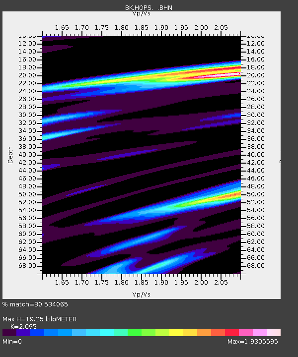
| Estimated Moho Depth: |
19.25 km |
| Estimated Crust Vp/Vs: |
2.10 |
| Assumed Crust Vp: |
6.472 km/s |
| Estimated Crust Vs: |
3.089 km/s |
| Estimated Crust Poisson's Ratio: |
0.35 |
|
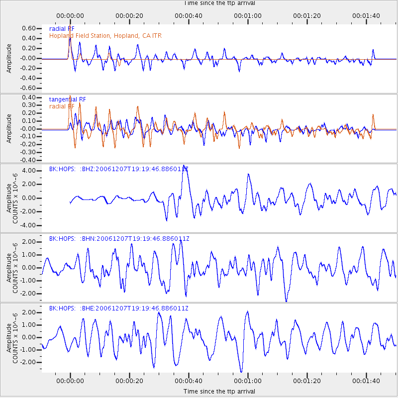
| Radial Match: |
80.534065 % |
| Radial Bump: |
400 |
| Transverse Match: |
69.35452 % |
| Transverse Bump: |
400 |
| SOD ConfigId: |
2564 |
| Insert Time: |
2010-03-05 19:20:02.805 +0000 |
| GWidth: |
2.5 |
| Max Bumps: |
400 |
| Tol: |
0.001 |
|
Signal To Noise
| Channel | StoN | STA | LTA |
| BK:HOPS: :BHN:20061207T19:19:46.886011Z | 1.8422066 | 6.16249E-7 | 3.3451676E-7 |
| BK:HOPS: :BHE:20061207T19:19:46.886011Z | 2.675849 | 8.0370154E-7 | 3.0035386E-7 |
| BK:HOPS: :BHZ:20061207T19:19:46.886011Z | 4.4006286 | 1.1908226E-6 | 2.7060284E-7 |
| Arrivals |
| Ps | 3.4 SECOND |
| PpPs | 8.8 SECOND |
| PsPs/PpSs | 12 SECOND |


