You are here: Home > Network List > BK - Berkeley Digital Seismograph Network Stations List
> Station HOPS Hopland Field Station, Hopland, CA > Earthquake Result Viewer
HOPS Hopland Field Station, Hopland, CA - Earthquake Result Viewer
| Earthquake location: |
Kuril Islands |
| Earthquake latitude/longitude: |
46.6/153.3 |
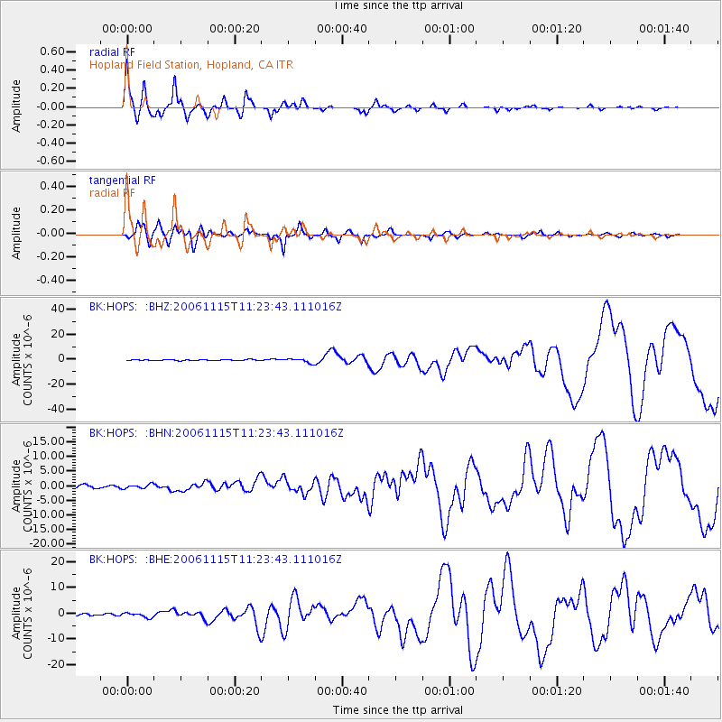
| Earthquake time(UTC): |
2006/11/15 (319) 11:14:13 GMT |
| Earthquake Depth: |
10 km |
| Earthquake Magnitude: |
6.5 MB, 7.8 MS, 8.3 MW, 7.9 MW |
| Earthquake Catalog/Contributor: |
WHDF/NEIC |
|
| Network: |
BK Berkeley Digital Seismograph Network |
| Station: |
HOPS Hopland Field Station, Hopland, CA |
| Lat/Lon: |
38.99 N/123.07 W |
| Elevation: |
299 m |
|
| Distance: |
59.1 deg |
| Az: |
64.473 deg |
| Baz: |
307.007 deg |
| Ray Param: |
0.06239483 |
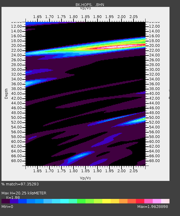
| Estimated Moho Depth: |
20.25 km |
| Estimated Crust Vp/Vs: |
1.98 |
| Assumed Crust Vp: |
6.472 km/s |
| Estimated Crust Vs: |
3.269 km/s |
| Estimated Crust Poisson's Ratio: |
0.33 |
|
| Radial Match: |
97.35293 % |
| Radial Bump: |
400 |
| Transverse Match: |
90.79991 % |
| Transverse Bump: |
400 |
| SOD ConfigId: |
2564 |
| Insert Time: |
2010-03-05 19:20:04.188 +0000 |
| GWidth: |
2.5 |
| Max Bumps: |
400 |
| Tol: |
0.001 |
|
Signal To Noise
| Channel | StoN | STA | LTA |
| BK:HOPS: :BHN:20061115T11:23:43.111016Z | 1.0347933 | 6.9671887E-7 | 6.7329285E-7 |
| BK:HOPS: :BHE:20061115T11:23:43.111016Z | 1.7080263 | 8.7773265E-7 | 5.138871E-7 |
| BK:HOPS: :BHZ:20061115T11:23:43.111016Z | 4.3025327 | 1.7080891E-6 | 3.9699617E-7 |
| Arrivals |
| Ps | 3.2 SECOND |
| PpPs | 8.9 SECOND |
| PsPs/PpSs | 12 SECOND |


