You are here: Home > Network List > BK - Berkeley Digital Seismograph Network Stations List
> Station HOPS Hopland Field Station, Hopland, CA > Earthquake Result Viewer
HOPS Hopland Field Station, Hopland, CA - Earthquake Result Viewer
| Earthquake location: |
Tonga Islands |
| Earthquake latitude/longitude: |
-20.2/-174.1 |
| Earthquake time(UTC): |
2006/05/03 (123) 15:26:40 GMT |
| Earthquake Depth: |
55 km |
| Earthquake Magnitude: |
7.2 MB, 7.8 MS, 7.9 MW, 7.9 MW |
| Earthquake Catalog/Contributor: |
WHDF/NEIC |
|
| Network: |
BK Berkeley Digital Seismograph Network |
| Station: |
HOPS Hopland Field Station, Hopland, CA |
| Lat/Lon: |
38.99 N/123.07 W |
| Elevation: |
299 m |
|
| Distance: |
75.8 deg |
| Az: |
38.691 deg |
| Baz: |
228.895 deg |
| Ray Param: |
0.051311567 |
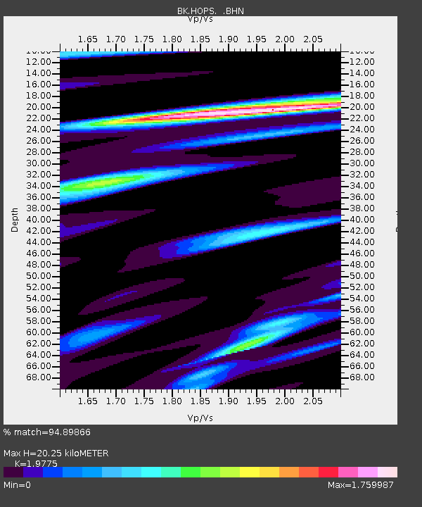
| Estimated Moho Depth: |
20.25 km |
| Estimated Crust Vp/Vs: |
1.98 |
| Assumed Crust Vp: |
6.472 km/s |
| Estimated Crust Vs: |
3.273 km/s |
| Estimated Crust Poisson's Ratio: |
0.33 |
|
| Radial Match: |
94.89866 % |
| Radial Bump: |
400 |
| Transverse Match: |
91.61281 % |
| Transverse Bump: |
400 |
| SOD ConfigId: |
2669 |
| Insert Time: |
2010-03-05 19:20:20.395 +0000 |
| GWidth: |
2.5 |
| Max Bumps: |
400 |
| Tol: |
0.001 |
|
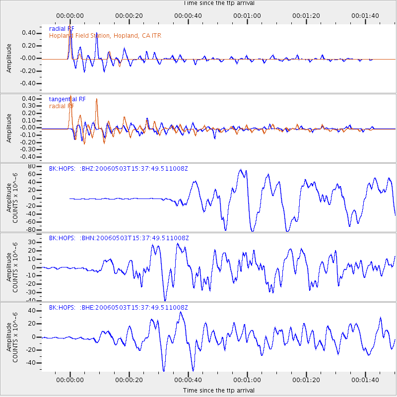
Signal To Noise
| Channel | StoN | STA | LTA |
| BK:HOPS: :BHN:20060503T15:37:49.511008Z | 0.7261482 | 4.6351036E-7 | 6.3831374E-7 |
| BK:HOPS: :BHE:20060503T15:37:49.511008Z | 2.5033767 | 1.1089671E-6 | 4.4298852E-7 |
| BK:HOPS: :BHZ:20060503T15:37:49.511008Z | 2.939213 | 2.0563132E-6 | 6.9961357E-7 |
| Arrivals |
| Ps | 3.1 SECOND |
| PpPs | 9.1 SECOND |
| PsPs/PpSs | 12 SECOND |


