You are here: Home > Network List > 8G - 2016 Pedernales Earthquake Aftershock Deployment Ecuador Stations List
> Station EC01 EC01 > Earthquake Result Viewer
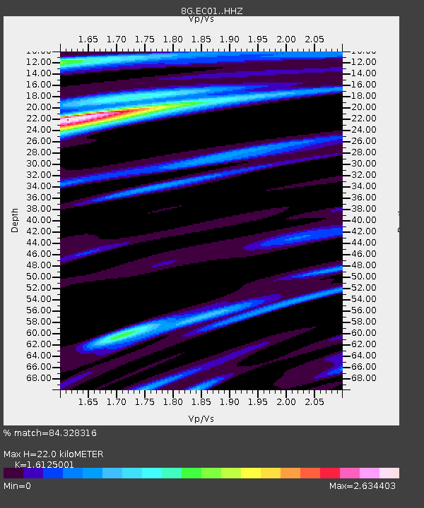
EC01 EC01 - Earthquake Result Viewer
| Earthquake location: |
Chile-Argentina Border Region |
| Earthquake latitude/longitude: |
-35.1/-71.0 |
| Earthquake time(UTC): |
2016/11/04 (309) 16:20:43 GMT |
| Earthquake Depth: |
91 km |
| Earthquake Magnitude: |
6.4 MWP, 6.4 MWW |
| Earthquake Catalog/Contributor: |
NEIC PDE/NEIC COMCAT |
|
| Network: |
8G 2016 Pedernales Earthquake Aftershock Deployment Ecuador |
| Station: |
EC01 EC01 |
| Lat/Lon: |
0.94 N/79.66 W |
| Elevation: |
65 m |
|
| Distance: |
36.8 deg |
| Az: |
345.415 deg |
| Baz: |
168.083 deg |
| Ray Param: |
0.07622206 |
| Estimated Moho Depth: |
22.0 km |
| Estimated Crust Vp/Vs: |
1.61 |
| Assumed Crust Vp: |
6.472 km/s |
| Estimated Crust Vs: |
4.014 km/s |
| Estimated Crust Poisson's Ratio: |
0.19 |
|
| Radial Match: |
84.328316 % |
| Radial Bump: |
400 |
| Transverse Match: |
77.19967 % |
| Transverse Bump: |
400 |
| SOD ConfigId: |
11737051 |
| Insert Time: |
2019-04-26 00:13:34.433 +0000 |
| GWidth: |
2.5 |
| Max Bumps: |
400 |
| Tol: |
0.001 |
|

Signal To Noise
| Channel | StoN | STA | LTA |
| 8G:EC01: :HHZ:20161104T16:27:12.290006Z | 2.8535597 | 5.2047353E-6 | 1.8239447E-6 |
| 8G:EC01: :HHN:20161104T16:27:12.290006Z | 0.7075281 | 2.4200597E-6 | 3.4204431E-6 |
| 8G:EC01: :HHE:20161104T16:27:12.290006Z | 0.9824015 | 2.7653348E-6 | 2.8148725E-6 |
| Arrivals |
| Ps | 2.3 SECOND |
| PpPs | 8.2 SECOND |
| PsPs/PpSs | 10 SECOND |


