
Station 8G EC01 - EC01
Network: 8G - 2016 Pedernales Earthquake Aftershock Deployment Ecuador
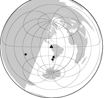
Nearby stations (2 deg radius)
| Station | Name | (Lat, Lon) | Start / End | Elevation |
| EC01 | EC01 | (0.94, -79.66) | 2016-05-01 / 2017-05-10 | 65 m |
| Crust2 Type: | T6,Margin /shield transition, 1 km seds. |
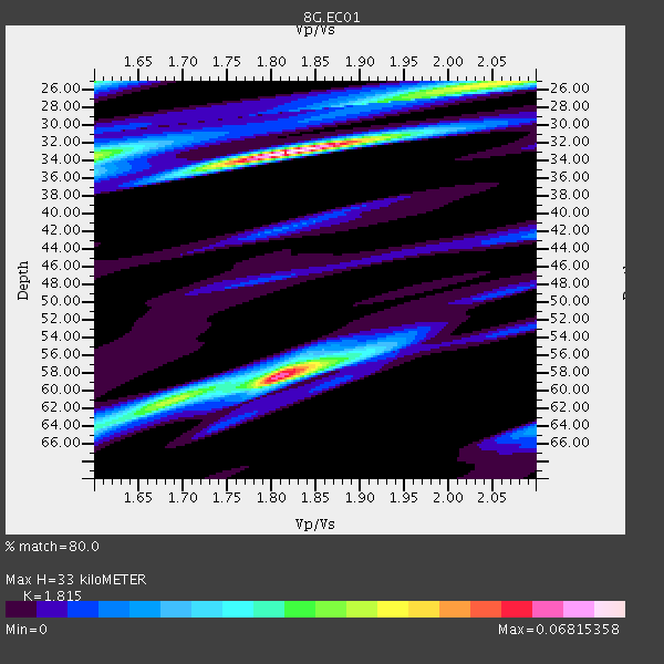
| Thickness Estimate: | 33 km |
| Thickness StdDev: | 15 km |
| Vp/Vs Estimate: | 1.82 |
| Vp/Vs StdDev: | 0.08 |
| Vs Estimate: | 3.566 km/s |
| Poisson's Ratio: | 0.28 |
| Peak Value: | 0.07 |
| Assumed Vp: | 6.472 km/s |
| Ps Weight: | 0.33333334 |
| PpPs Weight: | 0.33333334 |
| PsPs Weight: | 0.33333328 |
| Residual Complexity: | 0.782 |
| Nearby stations H: | +- |
| (2.0 deg) Vp/Vs: | +- |
0 with match > 90% ( 0.0 %) and 3 with match > 80% ( 33.333332 %) out of 9.
Download stack as xyz text file.
Azimuth Distribution of Events:
Prior Results for this Station
| Study | Thickness | Vp/Vs | Vp | Vs | Poissons Ratio | Extra |
| EARS | 33 km | 1.82 | 6.472 km/s | 3.566 km/s | 0.28 | |
| Crust2.0 | 32 km | 1.79 | 6.472 km/s | 3.622 km/s | 0.27 | T6,Margin /shield transition, 1 km seds. |
| Global Maxima | 33 km | 1.82 | 6.472 km/s | 3.566 km/s | 0.28 | amp=0.06815358 |
| Local Maxima 1 | 58 km | 1.81 | 6.472 km/s | 3.581 km/s | 0.28 | amp=0.06016561 |
| Local Maxima 2 | 25 km | 2.05 | 6.472 km/s | 3.161 km/s | 0.34 | amp=0.041249443 |
| Local Maxima 3 | 34 km | 1.60 | 6.472 km/s | 4.045 km/s | 0.18 | amp=0.039039016 |
| Local Maxima 4 | 25 km | 1.60 | 6.472 km/s | 4.045 km/s | 0.18 | amp=0.03106489 |
| Predicted Arrivals for vertical incidence (zero ray parameter) | |
| Ps | 4.16 SECOND |
| PpPs | 14.35 SECOND |
| PsPs/PpSs | 18.51 SECOND |
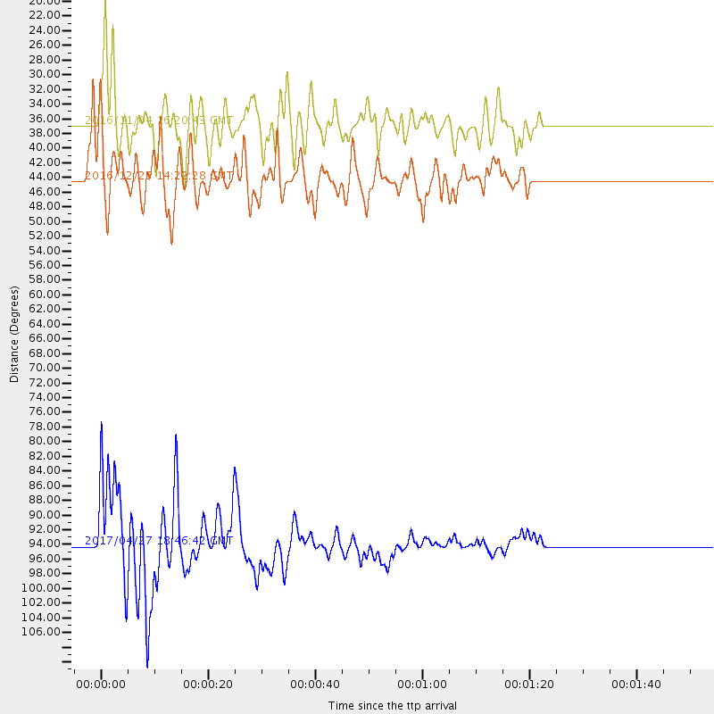
Events Processed for this Station
Download zip of receiver functions as SAC
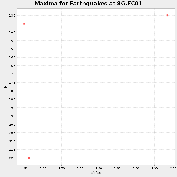
Plot maxima for each earthquake.
Events Used in the Stack
(3 events)| Radial Match | Distance | Baz | FERegion | Time | Lat/Lon | Depth | Magnitude |
| 84.328316 | 36.8 deg | 168.083 deg | Chile-Argentina Border Region | 2016/11/04 16:20:43 GMT | (-35.1, -71.0) | 91 km | 6.4 MWP, 6.4 MWW |
| 83.395 | 44.3 deg | 174.598 deg | Southern Chile | 2016/12/25 14:22:28 GMT | (-43.3, -74.5) | 15 km | 7.7 Mi |
| 80.44027 | 94.1 deg | 253.619 deg | Tonga Islands | 2017/04/27 18:46:42 GMT | (-16.5, -173.7) | 33 km | 5.5 mb |
Losers
(6 events)| Radial Match | Distance | Baz | FERegion | Time | Lat/Lon | Depth | Magnitude | Reason |
| 80.69445 | 71.1 deg | 151.938 deg | South Sandwich Islands Region | 2016/05/28 09:46:59 GMT | (-56.2, -26.9) | 73 km | 7.2 MWW, 7.3 MI | |
| 78.06324 | 30.5 deg | 306.255 deg | Off Coast Of Jalisco, Mexico | 2016/06/07 10:51:38 GMT | (18.4, -105.2) | 10 km | 6.2 MWP | |
| 76.4347 | 73.2 deg | 333.796 deg | Southeastern Alaska | 2017/05/01 12:31:53 GMT | (59.9, -136.6) | 0.1 km | 6.5 Ml | |
| 73.7672 | 34.0 deg | 163.241 deg | San Juan Province, Argentina | 2016/11/20 20:57:43 GMT | (-31.6, -68.8) | 116 km | 6.4 MWP, 6.5 MWB | |
| 42.633705 | 91.3 deg | 47.284 deg | Central Italy | 2016/10/26 17:10:37 GMT | (42.9, 13.0) | 10 km | 5.5 MWW | |
| 35.061092 | 97.5 deg | 239.993 deg | Kermadec Islands, New Zealand | 2016/06/06 02:35:32 GMT | (-30.0, -177.8) | 44 km | 6.1 MWW, 6.0 MWC, 6.1 MWC |

