You are here: Home > Network List > 8G - 2016 Pedernales Earthquake Aftershock Deployment Ecuador Stations List
> Station EC16 EC16 > Earthquake Result Viewer
EC16 EC16 - Earthquake Result Viewer
| Earthquake location: |
Chile-Argentina Border Region |
| Earthquake latitude/longitude: |
-35.1/-71.0 |
| Earthquake time(UTC): |
2016/11/04 (309) 16:20:43 GMT |
| Earthquake Depth: |
91 km |
| Earthquake Magnitude: |
6.4 MWP, 6.4 MWW |
| Earthquake Catalog/Contributor: |
NEIC PDE/NEIC COMCAT |
|
| Network: |
8G 2016 Pedernales Earthquake Aftershock Deployment Ecuador |
| Station: |
EC16 EC16 |
| Lat/Lon: |
0.11 S/80.19 W |
| Elevation: |
94 m |
|
| Distance: |
35.9 deg |
| Az: |
344.164 deg |
| Baz: |
167.071 deg |
| Ray Param: |
0.076708816 |
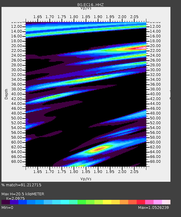
| Estimated Moho Depth: |
20.5 km |
| Estimated Crust Vp/Vs: |
2.10 |
| Assumed Crust Vp: |
6.183 km/s |
| Estimated Crust Vs: |
2.948 km/s |
| Estimated Crust Poisson's Ratio: |
0.35 |
|
| Radial Match: |
91.212715 % |
| Radial Bump: |
330 |
| Transverse Match: |
80.11483 % |
| Transverse Bump: |
400 |
| SOD ConfigId: |
11737051 |
| Insert Time: |
2019-04-26 00:13:41.195 +0000 |
| GWidth: |
2.5 |
| Max Bumps: |
400 |
| Tol: |
0.001 |
|

Signal To Noise
| Channel | StoN | STA | LTA |
| 8G:EC16: :HHZ:20161104T16:27:04.660001Z | 19.977446 | 3.6709382E-6 | 1.8375414E-7 |
| 8G:EC16: :HHN:20161104T16:27:04.660001Z | 8.8859825 | 2.0858022E-6 | 2.3472948E-7 |
| 8G:EC16: :HHE:20161104T16:27:04.660001Z | 3.7243547 | 9.982239E-7 | 2.6802599E-7 |
| Arrivals |
| Ps | 3.9 SECOND |
| PpPs | 9.7 SECOND |
| PsPs/PpSs | 14 SECOND |


