
Station 8G EC16 - EC16
Network: 8G - 2016 Pedernales Earthquake Aftershock Deployment Ecuador
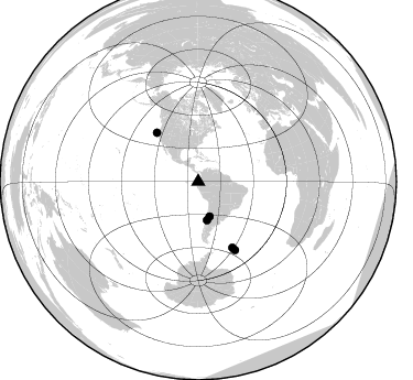
Nearby stations (2 deg radius)
| Station | Name | (Lat, Lon) | Start / End | Elevation |
| EC16 | EC16 | (-0.11, -80.19) | 2016-05-01 / 2017-05-10 | 94 m |
| Crust2 Type: | S1,continental slope, margin, transition 1 km seds. |
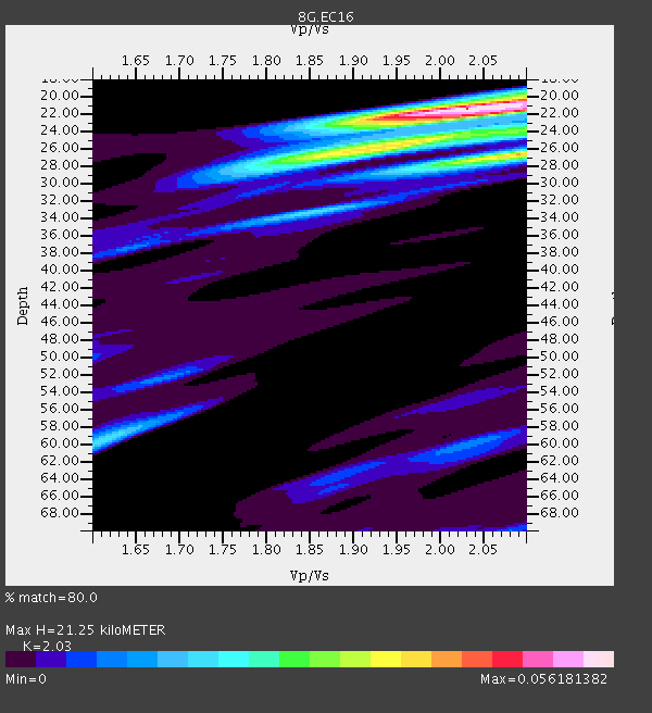
| Thickness Estimate: | 21 km |
| Thickness StdDev: | 7.8 km |
| Vp/Vs Estimate: | 2.03 |
| Vp/Vs StdDev: | 0.09 |
| Vs Estimate: | 3.046 km/s |
| Poisson's Ratio: | 0.34 |
| Peak Value: | 0.06 |
| Assumed Vp: | 6.183 km/s |
| Ps Weight: | 0.33333334 |
| PpPs Weight: | 0.33333334 |
| PsPs Weight: | 0.33333328 |
| Residual Complexity: | 0.622 |
| Nearby stations H: | +- |
| (2.0 deg) Vp/Vs: | +- |
3 with match > 90% ( 14.285714 %) and 5 with match > 80% ( 23.809525 %) out of 21.
Download stack as xyz text file.
Azimuth Distribution of Events:
Prior Results for this Station
| Study | Thickness | Vp/Vs | Vp | Vs | Poissons Ratio | Extra |
| EARS | 21 km | 2.03 | 6.183 km/s | 3.046 km/s | 0.34 | |
| Crust2.0 | 23 km | 1.81 | 6.183 km/s | 3.422 km/s | 0.28 | S1,continental slope, margin, transition 1 km seds. |
| Global Maxima | 21 km | 2.03 | 6.183 km/s | 3.046 km/s | 0.34 | amp=0.056181382 |
| Local Maxima 1 | 26 km | 2.09 | 6.183 km/s | 2.958 km/s | 0.35 | amp=0.039504163 |
| Local Maxima 2 | 26 km | 1.93 | 6.183 km/s | 3.208 km/s | 0.32 | amp=0.03358855 |
| Local Maxima 3 | 59 km | 1.62 | 6.183 km/s | 3.828 km/s | 0.19 | amp=0.018608 |
| Local Maxima 4 | 24 km | 2.10 | 6.183 km/s | 2.948 km/s | 0.35 | amp=0.016519941 |
| Predicted Arrivals for vertical incidence (zero ray parameter) | |
| Ps | 3.54 SECOND |
| PpPs | 10.41 SECOND |
| PsPs/PpSs | 13.95 SECOND |
Events Processed for this Station
Download zip of receiver functions as SAC
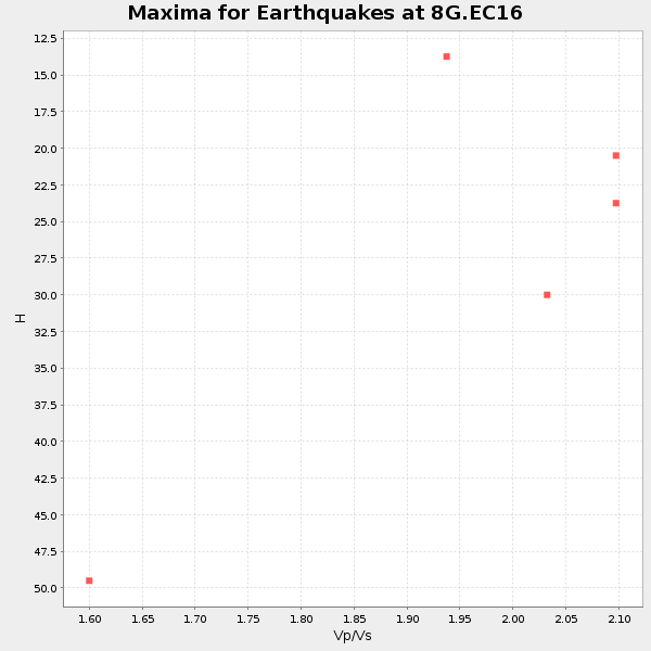
Plot maxima for each earthquake.
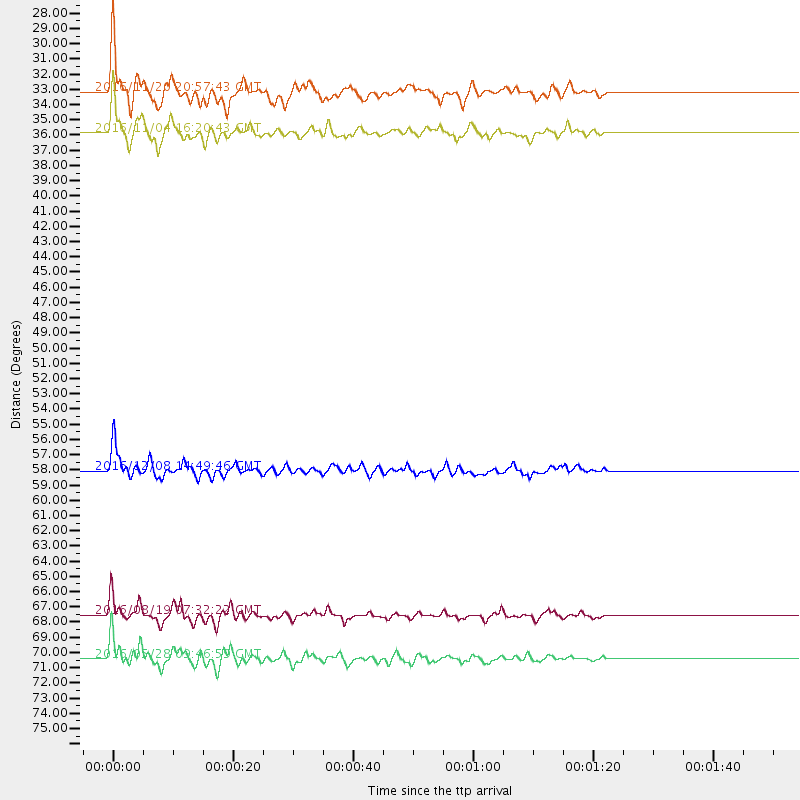
Events Used in the Stack
(5 events)| Radial Match | Distance | Baz | FERegion | Time | Lat/Lon | Depth | Magnitude |
| 96.27114 | 70.4 deg | 151.599 deg | South Sandwich Islands Region | 2016/05/28 09:46:59 GMT | (-56.2, -26.9) | 73 km | 7.2 MWW, 7.3 MI |
| 94.030624 | 33.2 deg | 162.009 deg | San Juan Province, Argentina | 2016/11/20 20:57:43 GMT | (-31.6, -68.8) | 116 km | 6.4 MWP, 6.5 MWB |
| 91.212715 | 35.9 deg | 167.071 deg | Chile-Argentina Border Region | 2016/11/04 16:20:43 GMT | (-35.1, -71.0) | 91 km | 6.4 MWP, 6.4 MWW |
| 88.343796 | 67.5 deg | 152.534 deg | South Georgia Island Region | 2016/08/19 07:32:22 GMT | (-55.3, -31.9) | 10 km | 7.4 MO |
| 86.777016 | 58.1 deg | 319.744 deg | Off Coast Of Northern California | 2016/12/08 14:49:46 GMT | (40.5, -126.2) | 12 km | 6.5 Mwb |
Losers
(16 events)| Radial Match | Distance | Baz | FERegion | Time | Lat/Lon | Depth | Magnitude | Reason |
| 95.355606 | 43.3 deg | 173.936 deg | Southern Chile | 2016/12/25 14:22:28 GMT | (-43.3, -74.5) | 15 km | 7.7 Mi | |
| 77.89053 | 40.9 deg | 54.073 deg | Northern Mid-Atlantic Ridge | 2016/06/21 16:26:34 GMT | (22.7, -45.1) | 10 km | 6.1 MWB | |
| 75.84439 | 30.7 deg | 308.191 deg | Off Coast Of Jalisco, Mexico | 2016/06/07 10:51:38 GMT | (18.4, -105.2) | 10 km | 6.2 MWP | |
| 73.689095 | 70.1 deg | 151.852 deg | South Sandwich Islands Region | 2016/07/31 11:33:20 GMT | (-56.3, -27.5) | 98 km | 5.9 MWW, 5.9 MWC, 5.9 MWB | |
| 67.69123 | 92.5 deg | 47.294 deg | Central Italy | 2016/10/30 06:40:19 GMT | (42.9, 13.1) | 10 km | 6.6 MWW, 6.6 MWR | |
| 65.09125 | 31.1 deg | 158.022 deg | La Rioja Province, Argentina | 2016/11/13 14:01:01 GMT | (-28.9, -67.5) | 110 km | 6.2 MB, 5.7 MWR | |
| 63.205128 | 95.4 deg | 241.979 deg | Kermadec Islands Region | 2016/07/13 12:11:13 GMT | (-28.0, -176.4) | 12 km | 6.3 MWB | |
| 56.860638 | 41.9 deg | 224.365 deg | Easter Island Region | 2016/09/12 06:51:53 GMT | (-28.8, -112.3) | 10 km | 5.8 mww | |
| 55.914413 | 30.9 deg | 165.264 deg | Near Coast Of Central Chile | 2016/06/06 13:21:59 GMT | (-30.1, -71.5) | 30 km | 5.4 Mww | |
| 54.79538 | 30.4 deg | 157.149 deg | La Rioja Province, Argentina | 2016/11/13 01:01:51 GMT | (-28.1, -67.3) | 121 km | 5.7 MB | |
| 53.759758 | 67.4 deg | 152.469 deg | South Georgia Island Region | 2016/08/19 17:33:40 GMT | (-55.2, -32.1) | 4.3 km | 5.8 MWW, 5.7 MWB, 5.8 MWC | |
| 47.113033 | 94.4 deg | 254.655 deg | Tonga Islands | 2016/10/25 16:10:01 GMT | (-15.4, -174.8) | 0.0 km | 5.8 | |
| 44.86203 | 51.2 deg | 88.748 deg | Central Mid-Atlantic Ridge | 2016/07/24 14:10:51 GMT | (0.9, -29.0) | 10 km | 5.7 mwb | |
| 36.295868 | 92.4 deg | 47.293 deg | Central Italy | 2016/10/26 17:10:37 GMT | (42.9, 13.0) | 10 km | 5.5 MWW | |
| 31.886873 | 66.8 deg | 98.017 deg | Ascension Island Region | 2016/06/10 09:26:53 GMT | (-7.5, -13.6) | 10 km | 5.5 MWP | |
| 31.670412 | 30.9 deg | 165.153 deg | Near Coast Of Central Chile | 2016/06/06 13:16:02 GMT | (-30.1, -71.5) | 30 km | 5.5 MWW, 5.4 MWB |

